Bottom pressure recorders (BPR) have long provided scientists with critical data about the ocean. But until now, their ability to gather data has been time-limited and hampered the ability to look at large and long-scale trends. Our Fetch AZA is now set to change the game by providing the capability to measure bottom pressure more accurately and for longer.
It’s often said that the ocean is the earth’s climate engine, and many would agree. That’s why understanding our planet’s major ocean currents is a critical element of ocean and climate science. The ocean is a big place, however. Deploying and retrieving sensors into it costs, especially when they have a limited lifespan due to calibration requirements.
That’s now about to change. Scientists researching how major ocean currents influence the Earth’s climate now have a game-changing tool to observe basin-wide oceanic systems, using our long-endurance ocean bottom pressure recorders.
The researchers, at the Scottish Association of Marine Science (SAMS), based in Oban, Scotland, are studying the Atlantic Meridional Overturning Circulation (AMOC). The AMOC is a large system of ocean currents in the Atlantic Ocean. It is driven by differences in temperature and salt content (i.e. density) that act like a vast “conveyor belt”, redistributing oceanic heat and influencing global temperature distribution, sea levels and carbon absorption.

It is thought to transport roughly 1.25 Peta (10^15) Watts of energy from the tropics towards the subpolar and Arctic regions – more than 60 times the present rate of world energy consumption. However, relating climate variability to the AMOC is dependent on a vast array of sensors spread across the Atlantic. Continuous measurements using these instruments, deployed on the seabed and on moorings in the water column, have only been recorded since 2004, and understanding of this relationship is still evolving.
Bottom pressure recorders – limited, until now
The instruments deployed across the Atlantic include ocean bottom pressure recorders. “By looking at the difference in pressure across the Atlantic, researchers can calculate the velocity of water, and therefore volume, flowing across this massive area,” explains Geraint West, head of science at Sonardyne.
“But all pressure sensors are subject to drift, which means they have to be regularly recalibrated, taking up valuable vessel time and cost, as well as interrupting valuable time series datasets.
“Now two of our instruments, placed either side of the Atlantic, near Scotland and Newfoundland, will give scientists a longer-term and more sustainable way to measure the massive meridional (i.e. south-north and vice versa) flow of water across this vast expanse – or any other large body of water for that matter.”
Long endurance, high accuracy: Fetch AZA
The two instruments are our Fetch AZA (ambient-zero-ambient) instruments. These incorporate long-endurance pressure sensors that are able to produce centimetric-scale pressure (depth) measurements down to 7,000 m deep. They’re able to do this, without sensor drift, for up to 10 years at a time, thanks to the AZA self-calibration mechanism.
This is a unique control system that periodically cycles the pressure sensor from ambient seabed pressure to near-zero, enabling comparison to a highly accurate low-pressure reference sensor for calibration. The reference sensor is never subjected to ambient pressure and is accurate to changes of less than a millibar, or about 1cm of head of water.
Fetch AZA also contain an acoustic modem, so data they gather, which can include third-party sensors, can be wirelessly transmitted to a ship up on the surface. Uncrewed vessels can be used to do this, again reducing reliance on crewed vessel support.
Focusing on the geostrophic balance

Dr Kristin Burmeister, co-chief scientist on the SAMS project explains how the two instruments will be used to gather the meridional velocity data they need for studying the AMOC: “Think about the daily weather report: Here, in the UK, when there is a low pressure system in the west and a high pressure system in the east, we will experience a wind along the isobars blowing from the south towards the north between the two pressure systems.
The larger the difference between the two pressure systems is, the stronger the winds are. This is what we call a geostrophic balance and it works exactly the same for ocean currents.”
To explain further, geostrophic balance is when the pressure gradient force and the Coriolis effect of the earth’s rotating motion balance out, forcing the air or water to flow parallel to the pressure isobars (the direction of flow will depend on which hemisphere it’s on).

“The bottom pressure observations gathered by the Fetch AZA instrument allows us to calculate the strength of the current flowing along the isobars between the two bottom pressure recorders. And as they are drift-free, we can now measure the very small but important climate relevant long-term variability of the current which was not able with previous bottom pressure sensors as they experience a large drift.”
An ocean physics first for Fetch AZA
It’s an exciting new application for Fetch AZA. “This is the first time that this instrument will be deployed (in ocean physics),” adds Dr Burmeister. “It will stay in the water for 10 years and data will be harvested remotely via an acoustic modem, without the need to recover the instrument. This opens a whole new way of sustainable, basin-wide volume transport observations.
“This is unprecedented for bottom pressure measurements. Because the sensors are drift free, the smallest changes over a long time period, like a continuous trend, will be identifiable within this new data. Before we could only study changes on time scales shorter than the deployment period.”
Sonardyne’s involvement in BPR technology covers a range of important applications. These include Tsunami detection, following the tragic events of the 2004 Boxing Day tsunami. The oil and gas industry also use them as an effective, low-cost way to undertake seabed deformation monitoring at offshore hydrocarbon reservoirs. Similarly, ocean scientists are using them to monitor geological plate tectonic activity and risk.
In order to support these diverse uses, Sonardyne has continuously invested in developing the accuracy of these sensor, the heart of which has been a pressure sensor characterisation capability. Sonardyne’s AZA capability is the next step in this process, unlocking further applications and new potential for science.
A whole lot more than bottom pressure recording
“While it has only been out in the field for a relatively short period of time, Fetch AZA has been applied to an increasingly wide range of applications,” adds Geraint. “Over the past year, we’ve seen one of our AZAs deployed on a cabled array off Vancouver Island to monitor plate tectonic activity in the Cascadia Subduction Zone.
“Similarly, the University of Washington will be deploying one on their cabled observatory in the Pacific Ocean, offshore Oregon to monitor an active underwater volcano – the Axial Seamount. The same instrument will be part of a wider array that will also measure lateral seabed movement, as well as acting as a navigation and communication network for underwater vehicles.
“This demonstrates the capability and flexibility of Fetch AZA. It’s such an exciting capability and we’re forever intrigued to see the applications that scientists around the world find for it, to help unlock their research and further our understanding of ocean and climate science.”
The bigger picture – OSNAP
But back to SAMS’s work in the Atlantic. Dr Burmeister’s work on the AMOC at SAMS is feeding into the UK element of a larger project, called the Overturning in the Subpolar North Atlantic Program (OSNAP).
The UK-OSNAP, led by the UK’s National Oceanography Centre, is aimed at improving understanding of the circulation and fluxes of the North Atlantic Subpolar Gyre; a large system of rotating currents driven by winds, in a region between roughly 45°N and 65°N.
The gyre is a key component of the climate system because it is a region where the ocean warms the atmosphere (keeping North Europe relatively mild) and because it draws atmospheric carbon dioxide into the deep ocean.
Knowledge and understanding of the functioning of the Subpolar Gyre have increased, but ocean measurements have been patchy in time and space. OSNAP began in 2014 and is now looking to new sustainable methods for monitoring the basin wide circulation.
Sonardyne’s Fetch AZA will be a key component of transitioning to cost-effective observing technologies so these vital climate processes can be monitored in a changing climate.

A schematic of the Overturning in the Subpolar North Atlantic Program Array. Warm currents in the upper one kilometer which flow north from the Gulf Stream and North Atlantic Current are shown in red. The warm water is made colder as it flows round the subpolar gyre and in the Nordic and Labrador Seas east and west of Greenland. The cold waters in blue return southward to the global ocean at depths of one to four kilometers. This is the overturning circulation.
To continuously monitor the strength and structure of all these currents an array of moorings is continuously deployed between Newfoundland and West Greenland and East Greenland and Scotland. A mooring is a wire (black) from the seabed to just below the surface and is held taught and vertical by syntactic foam and glass buoyancy (yellow blob). Instruments such as current meters, and temperature and salinity sensors are fixed to the wires (red blobs).
Every two years, over a period of three summer months all the moorings are recovered during research expeditions. The data from the instruments can be downloaded for analysis We then deploy new moorings and instruments for another two years.
In the Eastern Boundary Array autonomous gliders, patrol regions where it is difficult to install moorings safely (mainly due to fishing). Gliders have an endurance of six to eight months and are deployed and piloted by SAMS. The Sonardyne Fetch AZAs will be deployed at around ~1,800m deep on the 53°N array off Newfoundland and in the Eastern Boundary off Scotland.
Get in touch if you think Fetch AZA could support your scientific research.
TL;DR
Sonardyne’s long-endurance bottom pressure recorders could help scientists measure the AMOC more accurately over much longer periods, without the frequent recalibration that has limited older sensors. The big idea is that drift-free, remotely read pressure data may give climate researchers a better way to track Atlantic circulation, heat transport, and long-term change.
Subsea Technology and Rentals (STR), a multi-disciplinary technology expert specialising in the design, production, rental and sale of innovative marine survey equipment, has committed to a multi-million pound investment in seafloor, vehicle and vessel-based positioning hardware from marine technology company Sonardyne.
STR’s purchase includes Sonardyne’s Long BaseLine (LBL), Ultra-Short BaseLine (USBL) and inertial navigation systems, equipment which will support survey and construction projects across the offshore energy markets.
STR, a Baird Capital portfolio company, continues to significantly invest in new technology. The size and spread of equipment ordered is considered a clear sign of STR’s confidence in the offshore energy market, as activity levels rebound sharply through this year and beyond, and in the commercial and operational value Sonardyne’s innovative subsea technology brings to STR customers.
“We’re witnessing increasing demand for our technology and services across the Offshore Energy markets,” says Scott Johnstone, chief operating officer, at STR. “Timely access to the latest generation of hybrid subsea technology to get these shallow and deep water projects executed on time is critical to us and our customers, which is why we’re making this investment now”.
“The value that Sonardyne’s latest 6+ LBL hardware and INS systems bring to offshore operations is clear. Used with Sonardyne’s Fusion 2 combined LBL and INS topside software, surveyors can do more with less kit deployed. Using a single combined operating system makes set up time and complexity is reduced, compared with other systems. So subsea construction operations, from millimetre accurate metrology through to real-time SLAM calibration of sparse LBL arrays, are just simpler and faster.
“This is even more critical today than ever, as operators look to reduce, as practicably as possible, the carbon emissions associated with their projects, delivering the energy the world still needs, but with as low an impact as possible.”
STR’s order includes a large pool of Compatt 6+ LBL transponders, structure-mounted Gyro Compatt 6+s and ROV-mounted ROVNav 6+ ROV LBL transceivers. Sonardyne’s 6+ hardware uses the company’s exclusive Wideband 3 signal architecture, providing fast position updates of mobile targets as well as enabling sensor data, for example inclination and depth, to be embedded with acoustic ranging data – helping further de-risk operations at critical moments, such as structure touchdown.
STR has also invested in Sonardyne’s SPRINT-Nav hybrid underwater vehicle navigation technology. Combining Doppler-inertial navigation and depth sensing in a single pre-calibrated instrument, SPRINT-Nav offers high performance platform navigation without the challenges of separate sensors, size, weight, integration and alignment.
In addition, STR has invested in multiple Sonardyne Mini-Ranger 2 USBL systems and a large pool of Wideband Sub-Mini 6+ transponders (WSM 6+). In combination, Mini-Ranger 2 and WSM 6+ have fast become the go-to positioning system for offshore renewable energy site survey and characterisation operations, tracking and positioning a wide array of sensor systems. Quick to mobilise, easy to operate and then move to the next assignment, it’s a versatile and valuable rental pool asset.
“STR is very much a forward-looking company, both in terms of anticipating customer demand as activity increases, but also in terms of adopting the latest, most advanced technologies that provide the most value,” says Alan MacDonald, sales manager at Sonardyne.
“STR was the first company to invest our Syrinx DVL in 2016, followed up two years later by being the first to purchase Fusion 2, and our 6 plus hardware variants. We look forward to continuing to work with STR, supporting the company and its clients across the Offshore Energy market.”
Few would disagree that we need to learn more about our ocean. It’s one of the goals of the UN Ocean Decade. Whether it’s to understand more about how it impacts the earth’s climate, how we’re impacting marine ecosystems, as a resource for energy and food production or to inform maritime security, we have a lot to learn.
It’s all underpinned by ocean data collection, says Aidan Thorn, business development manager, Marine Robotics.
Throughout the last two decades, major in-roads into ocean observation have been made. Persistent autonomous underwater sensors and now corresponding autonomous surface systems are in regular use.
Used together, maritime autonomous systems (MAS), such as uncrewed surface vessels (USVs), and long-endurance seabed sensors are allowing us to collect ocean data with greater temporal and spatial coverage than has been possible before – without the need for large crewed ships. This is both making ocean data collection easier to access, safer and more sustainable.

Large-scale ocean data collection
We recently completed what we believe is one of the largest ocean data collection missions carried out in the commercial realm. With one XOCEAN USV, we collected data from 75 seabed sensors deployed in water depths between 800 m and 1,100 m over an area equivalent to the Isle of Wight – all in just over 3 days (including 12 hours, each way, transit to site).
There are a number of elements involved in making these missions a success. You can read our white paper on how to plan a successful data harvesting mission using a USV here.
Maximizing data collection and delivery
One critical element is the data. By understanding exactly what data is needed, we’re not logging unnecessary amounts of data. For example, our long-endurance Fetch AZA sensors will be logging temperature, pressure, pitch and roll and battery level data and the manifold status. These data points will be trimmed to the relevant decimal point onboard the Fetch. We’ll also constrain what’s logged to what’s relevant, for example battery power consumption.
The data is then compressed, which removes any duplication, and sent via an onboard modem using our Wideband 2 digital signal processing to a transceiver on the USV. This could be our Dunker 6 or a Mini-Ranger 2 USBL transceiver. The spread spectrum techniques and intelligent data packet stitching we use to do this mean we maximise data delivery, with speeds of up to 9,000 bps.

The transceiver then uncompresses the data, as well as checks it’s all arrived correctly. If there is any missing data, this exact data will be re-requested, rather than all of the data needing to be resent.
Efficient data upload
Thanks to that high rate and efficient data delivery rate, the USV doesn’t have to loiter at each sensor site; it can just continue to travel along its pre-planned route, without drawing attention to itself. Data collection is also uninterrupted by other acoustic activity in the area. In the most recent data collection operation, this was offshore drilling operations, which had no impact on the data harvesting operation.
Throughout, our engineers are on hand to perform real-time quality control as the data is uploaded. This is then repeated as soon as the data lands, via secure satellite (or 4G or RF when in range), onshore, ensuring a successful mission. This is now a regular type of activity for us.

Decades of autonomous sensors
Here at Sonardyne, we’ve been developing and deploying autonomous sensors for more than two decades. Our sensors are being used to measure and monitor everything from centimetric movement of the seabed to large-scale ocean currents.
In the past, hard decisions had to be made around when and how frequently to mobilise a crewed vessel to collect this data. Now, developments in MAS and our ability to integrate our acoustic communications payloads into them have caught up with sensor capability, unlocking lower cost, lower carbon and safer ways to collect ocean data.
Faster, safer, cleaner ocean data collection
Not a year goes by that an oceanographer or naval institute doesn’t come up with a novel new application for these instruments. This trend will only increase now that they have these new ways to access their data faster and safer with less environmental impact and cost. As we also build more edge processing into our instruments, we’ll see yet more opportunities for sustainable, long-term ocean data collection.
If you’d like to learn more about how you can use USVs to collect your ocean data, why not read our white paper, Planning considerations for USV data collection. From your choice of sensor and vehicle through to managing the data collection operation itself, it’s a great end-to-end guide to data harvesting.
We can also do it all for you, through our turn-key USV data harvesting service. Get in touch to find out more.
Recent years have seen a significant uptake in remote operations. We think this trend will continue. With our Remote Offshore Access Module (ROAM) and increasing access to communications when a sea, from low earth orbit satellite constellations to cellular networks, your opportunities are wide open. Senior surveyor Cieran Ryan explains.
Over the last two years, remote working has, by necessity, become something of an everyday occurrence. But while many are now heading back into the office, not everyone will go back to working offshore. Using today’s communications infrastructure – satellite communications and cellular networks – we can monitor and operate systems at remote sites. We think this is a trend that will only grow, for a number of reasons.
It’s not entirely new, for a start. Being able to conduct or support operations from “the beach” was something many working offshore, including those in science and defence, had been exploring for some time. Remote operations reduces risk to humans and logistics requirements. The result is lower costs and greenhouse gas emissions.
Satellite communications already provide offshore wind farm technicians with connectivity to the beach and subject matter experts. As offshore wind proliferates and moves further offshore, use of satellite communications and locally based wind farm wireless communications networks will also aid future use of robotics. That could be uncrewed vessels, aerial drones or robot crawlers that inspect blades. The emergence of low earth orbit (LEO) satellite networks providing high-speed satellite broadband with low latency data transfer will only further support this trend.
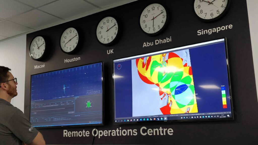
Remote operations support
Here at Sonardyne, we’ve embraced remote operations support. As I write, multiple operational vessels are requesting our Technology Services team’s support at locations all around the world, from the Black Sea to offshore Brazil and the North Sea. This for anything from overseeing the calibration of LBL arrays using the standard Least Squares techniques or the calibration of Sparse LBL arrays that combines the use of the SPRINT-Nav and Compatt ranges to SLAM (simultaneous localisation and mapping) calibrate the arrays. It could just be having our experts on hand to de-risk a particularly critical subsea construction project.
Remote Offshore Access Module – ROAM
Our remote services are provided through our Remote Offshore Access Module (ROAM) box. It’s a small box – similar to the size of a child’s lunch box – that contains everything needed to create secure connections from the Technology Service here team at Sonardyne to the vessels that need our support. That includes a secure VPN, giving the user piece of mind that their Sonardyne system is only being accessed by us and that it is a secure connection. The ROAM boxes are controlled from a cloud-based server that allows us to keep track of what is happening online and when support might be required.
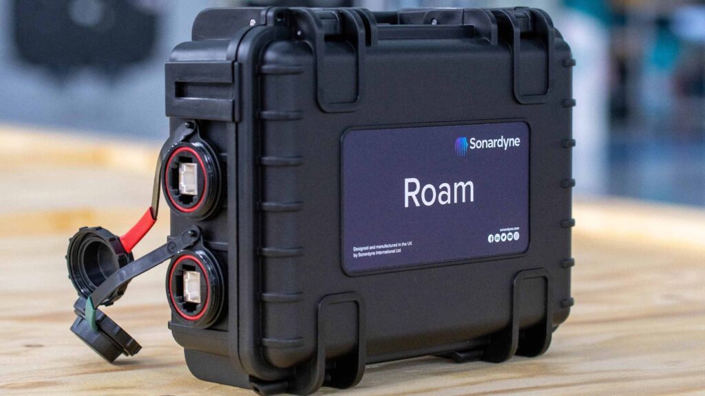
It’s a great way to reduce your persons on board numbers, cost and logistics, which also makes it an environmentally friendly solution. With a decent internet connection, surveyors onboard any vessel with a ROAM box connected have the peace of mind knowing that a Sonardyne specialist can dial in to their Fusion 2 system for support, should the need arise. We’ve found this to be particularly helpful to customers on either very complex projects, when they have new staff onboard or when they want to de-risk a project.

Getting connected for remote operations
But we all know what internet connections can be like. Not all vessels have good connection or even connection at all. Those that do can suffer from limited bandwidth and speed especially in rough conditions.
With the introduction of the likes of OneWeb, Starlink and other LEO satellite constellations, this technical restriction is set to become a thing of the past (with 100-125Mb/s speeds and 70ms latency). Unlike geostationary satellites, which sit around 35,000 km above the earth, LEO constellations contain a greater number of satellites that orbit much closer to the earth, at about 550 km in the case of Starlink. That means satellite broadband capability with lower latency than geostationary satellites.
Satellite or cellular
But while we wait for these systems to roll out, we don’t have to wait to continue to increase how much we do remotely today. As well as being able to use satellite services, ROAM also contains a SIM card. So, ROAM can also use cellular networks, which are easy to access inshore and are now available in large swathes of the North Sea and the Gulf of Mexico. We are also working on low bandwidth communications, which will improve speed and connection stability, even when we eventually get our data from LEO constellations.
A future augmented vision for remote operations
When LEO constellations become available, greater speeds and reliability will increase the access that we can be granted and level of support that we can offer. Looking a little further into the future, that could also take us into the augmented reality spectrum, as well as basic computer control.
LEO constellations offer other advantages, such as greater opportunities for near-real-time data processing and quality control on faster cloud-based systems. In turn, this could eventually help to reduce the total number of front-line operational staff required offshore. With ROAM, we can also keep developers in the loop as they can observe real time operations and fix any abnormalities should they occur.
So, the future is in fact now. Remote operations are now fully established and with new communications routes opening up like LEO constellations they will be even easier to access.
If you’d like to learn more or find out how we can support your operations, remotely, get in touch.
The University of Plymouth and marine technology company Sonardyne have agreed a strategic partnership to drive innovation within the UK’s growing marine robotics and autonomous systems sector.
The partnership will advance ocean data gathering technologies and platforms by leveraging the University’s academic resources and research facilities, Sonardyne’s leading acoustic and inertial navigation technologies, and the marine proving area Smart Sound Plymouth.
Under the new agreement, the partners will work together to evaluate and develop emerging technologies on the university’s fleet of crewed and uncrewed surface and underwater platforms, all underpinned by a suite of Sonardyne’s technologies.
This will include testing and evaluation onboard uncrewed systems loaned to the university by the Royal Navy, to support its research and development around maritime autonomous systems capabilities.
The partnership will help establish closer working relationships between the university and Sonardyne, including enabling undergraduate and postgraduate students to participate in the testing of cutting-edge equipment, as well as highlighting future career opportunities.
The initial three-year collaboration will also explore funding opportunities for joint research in areas of mutual interest, including ocean exploration, hydrography, ropeless fishing, offshore renewable energy and defence.
In addition, it will further the university’s global reputation for marine research and teaching, with Plymouth ranked 1st globally linked to United Nations’ Sustainable Development Goal number 14: life below water in the Times Higher Education Impact Rankings 2021.
While Sonardyne has worked closely with the university on a range of projects over many years, this new agreement aims to bring a more coordinated and targeted approach to fields of mutual interest.
[blockquote author=” Kevin Forshaw, Director of Industrial and Strategic Partnerships, Plymouth University’s Faculty of Science and Engineering”]”We are delighted to be deepening our collaboration with Sonardyne. The company has long-established connections with the city of Plymouth, and this new partnership will allow us both to push the boundaries of new technological development for remote and sustained ocean observation. It also ensures Plymouth remains at the forefront of driving innovation in high-growth market applications for the rapidly growing global ocean economy.”[/blockquote]
Geraint West, Head of Science at Sonardyne, added: “We have a long heritage in Plymouth and our roots in this historic naval city date back to 1982 – 40 years ago exactly. We have also based our trials and training centre in the city since 1993. Throughout those years, we’ve valued our role in supporting and collaborating with academia, so we’re delighted to be deepening our relationship with the University of Plymouth and in turn supporting the UK’s maritime autonomous cluster in this area.”
As the world’s smallest hybrid underwater vehicle navigator, SPRINT-Nav Mini is bringing a new level of performance to man-portable AUV/UUVs, ROVs and even hybrid surface and subsea vehicles.
Marine Robotics Business Development Manager Aidan Thorn explains how you can unlock more automation and ocean data with less when you add our ROV navigation capability – and then lets our robotics customers do the talking.
Access to our ocean is getting easier and simpler than ever. Small, portable remotely operated vehicles (ROVs) and autonomous or unmanned underwater vehicles (AUVs/UUVs) are now relatively low cost and easy to deploy, almost anywhere. They can be deployed from the beach, dockside and even from uncrewed surface vessels (USVs), allowing real-time control over the horizon. They’re even easy to control, through simple browser-based interfaces on your laptop.
But how effective are your results? How much more could you do with your ROV or AUV with an ROV navigation system onboard? How much easier would it be to control and automate? How much better could your data be, if only you could know precisely both when and where it’s gathering the data you need? How much more intelligence could you build into your marine robotic platform with more precise underwater navigation data?
Unlock your underwater robotics platforms
Many are finding out exactly these benefits and unlocking the capabilities of their smaller marine robotic platforms by adopting SPRINT-Nav Mini Navigator, the latest and smallest instrument in our SPRINT-Nav hybrid navigation family.
Launched late last year, SPRINT-Nav Mini Navigator is the world’s smallest hybrid acoustic-inertial navigation instrument and it’s already being used across multiple AUV and ROV platforms, from man-portable UUVs to inspection ROVs and even USVs.
By providing navigation capability, it’s allowing users to turn their vehicles into far more controllable and precise inspection, survey and manipulation platforms. It’s being used across the globe, from Asia to the Americas to Europe, and the energy, defence and science domains from mine countermeasures to offshore renewable energy survey and inspection.
A low-power, turn-key ROV navigation tool
Why? SPRINT-Nav Mini Navigator packs four of our instruments (INS, DVL, AHRS and depth) into one compact sensor. That means that’s it’s not only a third smaller than competing systems in the market, but it also benefits from our tight integration, so you get precision; an impressive 0.05% of distance travelled accuracy on a typical survey. It also makes it far easier to integrate than separates. You don’t need to worry about choosing and integrating a separate IMU, DVL and depth sensor.
Stats:
- 213 mm tall by 149 mm in diameter
- 700 g in air
- 200 m bottom lock altitude
It also comes pre-calibrated, so you can get running straight out of the box, and has a web user interface, so you don’t even need separate software to run it. And, to simplify your mounting configuration, it comes with connectors either on top of the unit or to the side, which can be particularly helpful for compact AUVs.
For shallower water operations (up to 300 m), it adds a mere 700 grams to your payload. If you want to go down to 4,000 m, it’s still only 4.2 kg with our titanium housed variant.
SPRINT-Nav Mini Navigator – what our users think
University of Southampton – AUV navigation

A team of marine researchers at the University of Southampton are integrating a SPRINT-Nav Mini and one of our AvTrak navigation and communications transponders into a SPARUS II AUV, built by Iqua Robotics in Spain. The vehicle also has a Voyis Recon LS laser and stills high-resolution 3D visual mapping system. The combined system will allow millimetre-resolution 3D visual reconstructions of underwater scenes to generated and accurately georeferenced.
Blair Thornton, Professor of Marine Autonomy at the University of Southampton says: “Combining precise self-localisation, high-resolution mapping and underwater communication capabilities has typically only been possible on platforms weighing several hundreds of kilograms. The large size of these platforms makes them reliant on large and expensive research vessels for deployment and recovery.
“Being able to pack this capability onto a compact AUV weighing <100kg is exciting because it makes advanced mapping significantly more accessible, not only for research, but also local conservation and educational initiatives that would not otherwise be possible.”
Funded by the Engineering and Physical Sciences Research Council and Higher Education Innovation Fund, the team at the University of Southampton will use the platform for both fundamental robotics research and applied research in offshore infrastructure inspection and marine conservation.
The platform’s capabilities will be a focal point for interdisciplinary and cross-sector collaboration, bringing researchers from the University of Southampton’s In Situ and Remote Intelligent Sensing Centre of Excellence, Southampton Marine & Maritime Institute and the Intelligent & Resilient Ocean Engineering Centre of Excellence, together will local industry, regional authorities and overseas research organisations.
Seatronics – ROV navigation

Acteon Group company Seatronics is integrating SPRINT-Nav Mini Navigator onto its VALOR ROV, a vehicle designed to be the smallest, most powerful and capable inspection class ROV in its category.
SPRINT-Nav Mini Navigator will provide VALOR with accurate, precise and robust ROV navigation and control, supporting Seatronics in its goals to further extend the boundaries of remote operations with tasks ranging from underwater inspection in lieu of dry-docking (UWILD) through to mine identification and destruction.
“Specifying payload sensors for a vehicle like VALOR often requires a trade-off between accuracy, performance, price and ownership. SPRINT-Nav Mini offers both the survey positional accuracy our clients are looking for, and a small form factor that we can fit and put straight to work.
“Another key reason for investing in SPRINT-Nav Mini is our ongoing relationship with Sonardyne. We knew that we would be fully supported in our concept to push the boundaries of remote operations from a small ROV solution by the Sonardyne team. This is critical when adopting new technology for a new platform,” Derek Donaldson, Seatronics’ Group Managing Director.
SEAMOR Marine – ROV navigation

SPRINT-Nav Mini Navigator
Canadian ROV company SEAMOR Marine is integrating a SPRINT-Nav Mini Navigator on to its newest ROV, the Mako. It’s a small yet flexible vehicle, with eight thrusters and up to 22.5 kg payload, including multi-beam imaging sonars, making SPRINT-Nav Mini Navigator an ideal complementary sensor.
Robin Gang Li, SEAMOR Marine President, said, “We’re really impressed with the capabilities of the SPRINT-Nav Mini Navigator. It’s ideal in terms of size, weight and power for our Mako system and we’re currently exploring with customers and the team at Sonardyne how we can create application specific turnkey solutions.”
Voyis
Covelya Group company Voyis will integrate SPRINT-Nav Mini Navigator into small ROVs to demonstrate windfarm inspection capability from USVs as part of the Autonomous Remote Offshore Wind Inspection, Navigation and Deployment (AROWIND) Project.
This Ontario-led project, supported with Canadian Ocean Super Cluster funding, will develop a USV-based subsea inspection solution for offshore windfarms. Deep Trekker, HydroSurv Unmanned Survey and ourselves and EIVA, also from the Covelya Group, are partners on the project.
“We chose SPRINT-Nav Mini for the AROWIND project for its compact size, which makes it really well suited for small ROV integration. Also, the fact that the INS, DVL and depth sensor functionalities all come pre-calibrated, in a single housing, drastically reduces integration complexity and risk,” says Chris Gilson, CEO at Voyis.
SPRINT-Nav Mini Navigator is also making waves in the US defence space. Defence technology companies there are using SPRINT-Nav Mini Navigator as their ROV navigation system on vehicles including an ROV and UUVs.
If you want to know how our SPRINT-Nav Mini Navigator could support your underwater robotics, drop us a line. We’ll be happy to help.
Moving offshore wind turbines into deeper waters will tap vast new areas of potential wind energy. But moving dynamic systems into an even more dynamic environment comes with its challenges, not least when it comes to dynamic cable monitoring, protection and management.
If there’s one thing we’ve learned from the past three decades of building offshore wind farms, it’s that the offshore environment is highly dynamic. There are a multitude of constantly shifting factors that we need to consider, above and beneath the waves, from leading edge erosion to the protection and management of power cables.
So what will happen when we evolve our wind turbines from fixed structures into floating structures in deep water? Put it another way, what happens when we introduce a dynamic system into an even more dynamic environment? One answer is that we get more yield and access to more capacity. Another answer is that we open up a new world of dynamic and environmental complexity.
There is a lot that the industry has already learned, the hard way. We’re talking better understanding of cable protection systems, cable depth of burial and free spans. I think it’s fair to say that the industry slightly underestimated the impact of the subsea environment in these areas. We have come a long way.
A new focus on dynamic cable monitoring
But, as we move turbines from static foundations onto dynamic platforms and into even more dynamic environments, there will be even more to learn, particularly around cable behaviour, protection and management. In these environments, cable behavioral patterns will differ, even within a localised area, due to small variations across the subsea environment, as well as variations in catenary designs. Export and cable arrays will now be exposed to potentially damaging factors such as:
- Hydrodynamic drag forces,
- Touch down point migration
- Cable compression
- Protection sleave movement
- Platform induced motion
- Vortex-induced vibrations
The challenge is to understand these forces so that we can resolve or counteract them, which becomes more important as our individual assets – reaching and going beyond 15 MW – represent an ever-greater proportion of our project. While we can build models, they only get us so far without having to build in large error margins due to the level of uncertainty involved in a design. So, we need real-world data.
Learning at the floating wind demonstration phase
At the demonstration stage, real-world dynamic cable monitoring data will allow us to enable, teach, and verify our models. But as we move into commercial-scale operations, it will help to reduce our error margins and increase safety, efficiency and yield – reducing project risks and long-term costs. Longer term, it will provide assurance of fatigue life and system performance and enable us to predict and remedy faults before they cause system outages, helping to rationalize maintenance regimes and be more confident when it comes to field life extension.
Five decades underwater positioning and monitoring
With our underwater acoustic and inertial systems, twinned with smart analytics, we’ve been helping operators understand how their underwater infrastructure is influenced by dynamic subsea environments for decades.
In fact, at Sonardyne, we have been positioning and monitoring underwater infrastructure since it was founded in 1971. We’ve been there, from the very first tension leg platform, Hutton, in 1983, through to complex deepwater floating production, storage and offloading vessel mooring and riser systems. We’ve learned how to integrate a combination of wireless subsea technologies to create a subsea integrated network that gives operators a full, real-time picture of dynamic behaviors. These range widely, from pipeline buckling and blow-out preventer inclination through to vortex-induced vibration of risers, including automated alerts and warnings when systems move out of set parameters.

Marine risers – a behavioral equivalent to power cables, delivering energy in its liquid or gaseous form to the surface – are often subject to significant forces through the water column. By monitoring them with an integrated suite of wireless subsea acoustic sensors, operators can better calculate the fatigue life of the subsea infrastructure and monitor for any events deemed outside their operating envelope. This could be points deemed most susceptible to cause catastrophic failure, such as the tether and anchor line and the touchdown point. Exactly the same can be done for floating offshore wind infrastructure.

SMART technology for subsea monitoring and analysis
Our SMART technologies have everything you need to measure cable and ancillary system, mooring lines and subsea environment behaviour, whether that’s using a SMART transponder to measure high-frequency vibration at the bend restrictor or seabed mounted inverted positioning system to measure the position of a slow oscillating dynamic cable. SMART stands for Subsea Monitoring, Analysis and Reporting Technology. That’s also because they’re easy to interface with third-party sensors, for example, a strain gauge to monitor load or tension on either the cable ancillary system or mooring lines.
The SMART transponders will report back to our seabed-mounted SMART technology hub that supports edge analytics, so you can manage the information you want, when you need it, not just a mass of data. Most of our instruments are capable of long-term deployment (i.e. up to at least 10 years, with our existing batteries) and support both on-demand data retrieval or send alerts when a threshold or pre-programmed metric is hit.
Building a bigger picture with current data
To build a wider, holistic picture, we would also recommend gathering underwater environmental data, using acoustic Doppler current profilers (ADCPs). These can also be integrated into our wireless network. Leaving ADCPs on the seabed and harvesting data throughout the entire wind farm lifecycle will lead to larger data sets that enable more accurate simulation and predictive modelling of the subsea environment.
Scalable dynamic cable monitoring systems to suit all sites
However, we see that not all floating offshore wind farm sites are born equal. Topography and metocean characteristics, such as water depth, current regimes and seabed characteristics, will differ between arrays. Where there’s a greater confidence in the characteristics at one site or more stable weather patterns, you might want to “spot” monitor one or two turbine locations early in your project life, to verify and build confidence your existing models for the entire farm. Where there’s a higher level of uncertainty or environmental risk, such as, northern North Sea, offshore Brazil or in the Gulf of Mexico, where there are complex current and eddy regimes, you may want a more comprehensive monitoring system or even to monitor throughout field life to better predict and manage cable behaviour. The options are easily scalable and tailored to individual sites.
If you want to learn more about the dynamic behaviour characteristics of the dynamic cables in your floating offshore wind farm by gathering real-world data, contact our team.
After more than 100 years lost more than 3,000 m underneath sea ice in the Antarctic’s Weddell Sea, the almost fully intact wreck of Ernest Shackleton’s Endurance has been found, supported with underwater navigation and positioning technology from Sonardyne.
The pioneering search, launched in February this year, saw the Endurance22 team deploy Saab Seaeye Sabertooth hybrid autonomous underwater vehicles (AUVs) from the icebreaking polar supply and research ship S.A. Agulhas II.
During their hunt of the seabed, close to where the 1914-1917 expedition came to its end, these underwater robots used Sonardyne’s SPRINT-Nav hybrid acoustic-inertial navigation system (INS) technology navigate their search routes. They also used Sonardyne’s AvTrak 6 tracking and telemetry transceiver, to send commands and position updates from a Ranger 2 Ultra-Short BaseLine (USBL) system, also from Sonardyne, onboard the S.A. Agulhas II.
[blockquote author=” Geraint West, Head of Science at Sonardyne”]”It is amazing what the team have achieved, given the extreme depths and under-ice conditions they were working in. The stunning condition of Shackleton’s Endurance as it rests on the seabed, like it’s been frozen in time, really is astounding and beyond our wildest hopes.”[/blockquote]
“We’re thrilled that it was our positioning and navigation technology and expertise that were chosen to support this what can only be called extreme science mission and we congratulate the Endurance22 team on their historic discovery. I’m sure this is also just the start of the story, as we begin to learn more about remains of this historic ship.”
For ease of deployment, the Ranger 2 was configured with a Gyro USBL transceiver. This comes with inbuilt attitude, heading and reference sensor (AHRS) and is pre-calibrated, making it easy to deploy on vessels of opportunity. A second Ranger 2 Gyro USBL system was also on hand, ready to be deployed from the surface of the ice, if the S.A. Agulhas was unable to get through the Weddell Sea’s sea-ice. Both were LMF systems, enabling tracking at ranges beyond 7,000 m, to meet the Endurance22 team’s potential under-ice tracking requirements.
Sonardyne’s sister company, Voyis, also had equipment on the project. Its Insight Pro and Observer stills camera were integrated into the Saab Sabertooth to generate 3D models and capture high-resolution true colour images of the wreck, all geolocated by Sonardyne navigation data. Another sister company of Sonardyne, EIVA, provided the data visualisation software.
The Endurance22 expedition was organised and funded by the Falklands Maritime Heritage Trust.
Submersible manufacturer MSubs and marine robotics technology company Sonardyne have signed a strategic partnership to advance the capabilities of long endurance, autonomous underwater platforms for the UK defence sector.
The Memorandum of Understanding (MOU) will see the two companies working to integrate and evaluate Sonardyne’s commercial-off-the-shelf navigation, communications and imaging payloads into MSubs 9 m-long extra-large uncrewed underwater vehicle (XLUUV) to provide naval forces with enhanced situational awareness across the underwater battlespace
From Plymouth, south-west England, where both companies have research, trials and manufacturing facilities, Sonardyne will supply and support a suite of its technologies to MSubs. These will include SPRINT-Nav X, a hybrid inertial-Doppler navigation sensor that’s suitable for GNSS-denied environments; AvTrak 6, a long-range tracking, command and control instrument; and Vigilant, a forward-looking obstacle avoidance sonar (FLS) jointly developed by Sonardyne and sister company Wavefront Systems.
MSubs’ XLUUV has been selected by the UK’s Royal Navy to help it understand the future roles for XLUUVs for surveillance, reconnaissance and anti-submarine warfare (ASW) missions, and deliver new capabilities to the organisation years earlier than otherwise be possible.
In 2021, MSubs and Sonardyne took part in the first phase of the UK’s Defence and Security Accelerator’s (DASA) Uncrewed Underwater Vehicle Testbed – Opportunity to Integrate competition, run jointly with the Royal Navy and the Defence Science and Technology Laboratory (Dstl). As part of the demonstration, MSubs’ XLUUV used bathymetric data gathered by its Vigilant FLS to navigate in open waters off Plymouth.
Today’s announcement builds on this success, with the two companies targeting further emerging opportunities from the UK’s Ministry of Defence, such as Project CETUS. This will see the design and build of an extra-large autonomous underwater vehicle (AUV) which may one day work alongside the Astute-class attack submarines.
[blockquote author=” Brett Phaneuf, Managing Director of MSubs”]”The integration of Sonardyne equipment on our extra-large AUV is a key factor for our continued success, helping us to move the state of the art forward swiftly. The operator-centric approach to engineering from Sonardyne and MSubs makes it easy to enhance our vehicle performance and reliability through applied research, bringing much needed capability to the underwater domain and greatly reduced timelines and budgets.”[/blockquote]
Ioseba Tena, Head of Defence at Sonardyne, added: “Our two companies are at the forefront of the development of unmanned platforms and payloads that are reshaping the underwater battlespace playbook; delivering tactical edge to navies and governments facing new, and increasingly capable underwater adversaries. We’re excited to be opening a new chapter of collaboration with the MSubs team, and where better for that collaboration to be centred on than Plymouth, the UK’s marine autonomy city.”
Marine technology company Sonardyne will use next week’s Oceanology International exhibition and conference in London to present the first of its new products and services for 2022 targeted at answering operational challenges across energy, defence and science.
On Sonardyne’s stand, F300, and as part of the daily in-water programme, visitors will be able to experience innovations for crewed and uncrewed vehicle platforms, seafloor and structure surveillance, and remotely connected, over-the-horizon missions.
Making its global tradeshow debut is Initiation Transponder 6 (IT 6), an entirely new way to remotely and securely activate mine neutralisers used in unexploded ordnance (UXO) and mine countermeasures (MCM) clearance operations. It can be placed by a remotely operated vehicle (ROV) or diver and is suitable for both high order detonation and low order deflagration methods.
IT 6s are controlled using Deck Topside, Sonardyne’s new portable control unit that can be used all day, in any weather, and from any size of boat. Sonardyne is using Oi2022 to show how Deck Topside is the future of its back-deck command, control and communications offering with the first look at a valuable functionality addition.
With Deck Topside, users can now acoustically test, load, interrogate and activate their Sonardyne RT 6 acoustic release transponders, as well as IT 6s, simplifying the topside choices on offer.
On start-up, users simply decide which mode they want Deck Topside to operate in; RT 6 or IT 6, with the 7-inch touchscreen displaying a bespoke user interface configured for that particular operation.
Oceanology also sees the arrival of the latest release of Fusion 2, Sonardyne’s LBL and INS software package. The latest release includes boosting Fusion 2 to 64-bit capability. The increased program performance this provides has resulted in faster processing and the most stable version of Fusion 2 ever.
GNSS signal loss when operating in built-up inland waterways and near large offshore structures, such as wind turbines, is a problem Sonardyne’s SPRINT-Nav family will address during its two daily in-water demonstrations at the show. SPRINT-Nav combines DVL, INS, AHRS and depth sensing in one easy to integrate instrument. Sonardyne will show how, with SPRINT-Nav fitted to any inshore, uncrewed or shallow-water DP vessel, independent, high-grade navigation can be continually available.
Staying with challenging operational environments, Sonardyne’s has brought a Mini-Ranger 2-enabled USV to the dockside to highlight the features that make this USBL system a great choice for high elevation underwater tracking, the ultimate test for any underwater positioning system.
Back inside, on stand F300, experts from the company’s Technology Services and Custom Projects groups will be on hand in a dedicated consultation zone, figuring out the subsea engineering challenges visitors are encouraged to present the team with.
[blockquote author=” Steve Martin, Sales Director at Sonardyne”]”Whilst the specific application challenges our clients face vary from renewables to underwater security, the need for marine technology which enables operations to be carried out responsibly, safely and efficiently is common. These needs are front and centre of our technology roadmap. Oceanology represents our first opportunity for what will be several product announcements that we have lined up over the course of this year. After two years of not being able to connect in person, we’re thrilled to welcome our industry back together again face-to-face to experience the latest innovation at Oi 2022.”[/blockquote]