It’s been brought to our attention that people think that Fusion 2 has taken away the need for a surveyor’s skills for long baseline (LBL) operations. Seeing it in action, maybe you could be forgiven for thinking that.
The screen tells you what you need to know, and you don’t need to read raw comms like the guy from the matrix to know what’s happening. You can still keep the comms window open to scare away the client rep if that’s your worry, but with Fusion 2’s advanced command scheduling you’d have to be a machine to read it all now anyway.
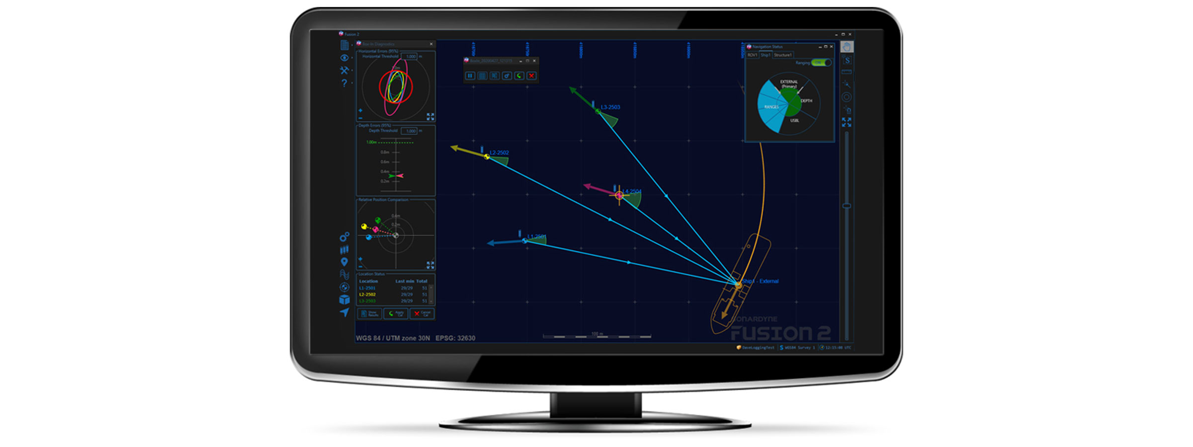
Real-time baseline calibration makes it much easier to see where and when things may be going wrong. An incorrect TAT, depth or position will be obvious in a few pings in the data collection, so no more having to deal with the ‘all or nothing’, ‘hit and hope’ feeling you had when postprocessing a data set for the first time, in days gone by. The hour or more playing with the errors in the calibration to get a nice fit, is now all done in minutes. This all allows you to grab a coffee and double check your numbers one more time, enabling you to focus on QC rather than firefighting bad data.

Adjustments can now be made in real time to the confidence values assigned to the position of each and every Compatt transponder, so one Compatt in a difficult location won’t reduce the overall quality of the array. Individual confidence values also mean you can use more types of position sources. For example, lower quality positions can be used to help orientate an array, alongside more accurate SLAM’d, acoustic box-in and published positions, if they are given a suitable error and meet your project specification. As each reference position has a different weighting in the least squares solution, performance isn’t lost in the way it was with the global scale error approach used in Fusion 1 to make difficult arrays fit the ranges.
Also true, is that interfacing to a USBL system for box-ins is now much simpler. Sonardyne and third-party USBLs can now use the same interface, negating the requirement to connect directly to USBL transceivers, and helping to standardise installations across vessels.

It’s true that the box-in itself is now also in real-time, giving the same benefits as already discussed for baselines. And to add to that, box-in collection also has new options for tidal compensation using GNSS height variation and tidal models, to control the corkscrewing of the vessel position as the tide changes as it sails the loop. This source of error could easily account for a 2m shift in typical oceanic conditions. But that just makes you look better, right?
I suppose as the GUI is nice to use, anyone could operate it once it is up and running, with a bit of training, but for those that have a deeper understanding and need to get the best performance from the system, the tools are there to do more than ever before, and faster. If you know how to use them.
Collecting and QC’ing data is often more than just meeting confidence levels, as these only test for random errors. Biased data is much harder to spot after the event. So, let’s not become complacent that this is easy. In customer support we still regularly deal with problems due to incorrect geodesy settings, poor sound speed control, incorrect depth datums and reductions, and pressure depth conversion confusion, so a good understanding and good practices are still as essential for success as ever.
Undersea weapon, sensors and integrated systems specialist Advanced Acoustic Concepts has chosen underwater positioning technology from maritime technology company Sonardyne to work for the US Department of Defense (DoD).
Advanced Acoustic Concepts chose Sonardyne’s portable Micro-Ranger 2 Ultra-Short Baseline (USBL) system following a market review of commercial-off-the-shelf (COTs) systems suitable for its needs, particularly around supporting its existing DoD programs and providing its operatives with increased situational awareness during open ocean missions
Micro-Ranger 2 is designed to provide everything needed to start tracking divers, remotely operated vehicles, autonomous or unmanned underwater vehicles or any other subsea targets, all from a single IP-67-rated ruggedised case small enough to operate anywhere, from anything.
It can track up to 10 targets to over 3,000 ft (995 m) and comes complete with a surface-deployed Micro-Ranger Transceiver, a GNSS antenna, and two of Sonardyne’s smallest transponders, the Nano. The one-box solution also houses a built-in battery to support more than 10 hours of continuous use, as well as ethernet and Wi-Fi connectivity to connect to a user’s laptop for fast and easy tracking.
[blockquote]Dan Zatezalo, Technical Sales Manager for Sonardyne in the US, says; We’re really excited to be supporting the work of such a technically strong company as Advanced Acoustic Concepts, which plays a critical part in supporting the US Navy. [/blockquote]
“COTS equipment is playing an increasing role in supporting wider military operations and systems like Micro-Ranger 2 are part of that eco-system; providing navies globally with affordable, easy to acquire, mobilize, and dependable maritime technologies.
“The flexibility of the hardware platform and secure digital signal architecture inside Micro-Ranger 2 means that customers can also benefit from being able to use and integrate our different navigation, communications and control mission systems, seamlessly, all with technical and application support from our facilities in the US.”
Advanced Acoustic Concepts, which is based in New York and has facilities in Maryland and Pennsylvania, is co-owned by Leonardo DRS and Thales.
So you’ve now met our new business development managers for offshore renewables, Mike Ellis, and marine robotics, Aidan Thorn. Now it’s time to meet our third new BDM, Michelle Barnett. Michelle’s moved over from doctoral research into ocean biochemistry to help oceanographers across the globe gain more insight, in whatever discipline they’re in.
As a Doctoral Researcher I found myself on research vessels year after year collecting data in the Western English Channel, offshore of Falmouth and Plymouth. Back then, my focus was phytoplankton communities within subsurface chlorophyll maxima and the significance of these features in a biogeochemical and ecological context. I used equipment ranging from an acoustic current Doppler profiler (ADCP) and conductivity, temperature, and pressure of seawater instrument (CTD) with a Niskin rosette sampler to a holographic camera system and a flow cytometer.

Fast forward three years and I am back in Plymouth. This time, it was aboard Sonardyne’s trials and training vessel, Sound Surveyor, getting hands-on with our (Sonardyne) equipment, including a Pressure Inverted Echo Sounder (PIES), SPRINT-Nav hybrid navigation instruments and the Mini-Ranger 2 Ultra-Short BaseLine (USBL) system. Being able to see this kit in action really makes you appreciate just how innovative, effective and easy to use Sonardyne technology is. But also how adaptive Sonardyne kit is to applications in defence, energy and ocean science.
Enabling oceanography with Pressure Inverted Echo Sounders
My focus is ocean science, so of course I was most fascinated by the science applications for these systems. Let’s start with PIES. It’s an instrument for simultaneously measuring two-way travel time through the water column and pressure at the seabed. It can be configured for autonomous monitoring over many months and even years. It also has an embedded acoustic modem, allowing for data retrieval without recovery of the device to the surface. Combining two-way travel time and pressure-derived depth enables average sound speed in the water column to be determined. This has obvious marine seismic applications, reducing uncertainty in the seismic data, but the capability to measure two-way travel time also has applications within the field of ocean science.

Here, a PIES is used slightly differently. Oceanographers measure two-way travel time because it is related to historical water column structure and enables density profiles to be derived. Not too long ago a mass deployment of modem-enabled PIES was used to map local horizontal velocity and density fields in the extended Loop Current System in the Gulf of Mexico, as part of a project to understand the processes underlying the Loop Current System. This is a major oceanographic feature, which has implications for harmful algal blooms, hurricanes, trophic dynamics… the list goes on.
A key advantage of PIES, with its integrated modem, is being able to supply near real-time data for input into forecasting models. With these, Loop Current System forecasts can be deduced that will be beneficial to a range of activities, including oil and gas operations, hurricane forecasting, fishing and tourism. From that one project alone, it’s not hard to imagine how PIES could play an integral role in future leading ocean research.
A powerful tool for tracking and communications – Mini-Ranger 2

On to Sonardyne’s Mini-Ranger 2 USBL system – engineered for underwater tracking and communications of anything from towed bodies to autonomous underwater vehicles. This system, together with the wider Ranger 2 family of USBL systems, fits in perfectly in an age where the use of uncrewed data collection platforms, surface and underwater, is becoming more and more prevalent for the ocean science community. With accurate and consistent tracking of uncrewed vehicles, the water column and seabed can be surveyed, analysed and managed more efficiently and effectively, maximising efficient use of precious vessel time. Of course, robots are not the only thing Ranger 2 systems can track; divers and underwater instruments can be too, presenting the science community with a flexible tool for collecting their data with confidence.
Make your underwater vehicles go further with SPRINT-Nav
The last system I want to mention today is SPRINT-Nav. It’s a hybrid navigation instrument that tightly couples our SPRINT INS, Syrinx Doppler velocity log (DVL) and a high-accuracy pressure sensor in a single, and surprisingly small, housing. This combination provides unprecedented levels of navigational capability for remotely operated vehicles (ROVs), uncrewed surface vessels (USVs) and autonomous underwater vehicles (AUVs).
If it is high performance, accuracy and reliability you need for your uncrewed underwater or surface vehicle, SPRINT-Nav is absolutely the instrument to choose. From an ocean science applications perspective, longer navigationally accurate ocean survey operations, in the absence of external references, is ideal for data collection in remote areas. For a sector that is often constrained by funding availability, SPRINT-Nav could certainly allow more ocean research opportunities to be explored and ultimately seized.
Over the past three years, I have changed from being a Doctoral Researcher in Ocean Biogeochemistry to Business Development Manager for Ocean Science, here at Sonardyne. Yet one thing has remained constant – my appreciation for the need for observational oceanographic data. The oceans are of great biogeochemical, physical and socio-economic importance and therefore it is critical that they are understood. This includes an awareness of how they are changing and how they may respond to future activities and events. Hence, there is a great and urgent demand for oceanographic data. The power, innovation and possibilities presented by our instruments are already helping with satisfying this demand and will continue to do so as observational ocean science continues to advance.
Combined long baseline (LBL) acoustic positioning and inertial navigation system (INS) software from energy technology company Sonardyne has helped to support the latest phase of an offshore project northwest Australia.
The project is the first full use of Sonardyne’s Fusion 2 software and associated 6 ‘plus’ (6+) hardware in Australia, cementing the global adoption of the new survey and construction technology in the wake of field development projects across Europe, North and South America, the Middle East and Asia.
In this latest deployment, geo-data insights firm UTEC, the lead brand for Acteon’s Geo-services segment, used Fusion 2 software and 6+ hardware in support of full and sparse LBL operations to position and install a new subsea well gathering system being tied back to an existing facility.
“Fusion 2 vastly simplifies topside interfaces and simplifies use, because it does the job of three systems, in one,” says Edd Moller, Sonardyne’s Head of Energy. “When used with our latest generation 6+ hardware, including the industry standard Compatt 6+ transponders and vehicle-installed ROVNav 6+ transceiver, it enables more to be done with less equipment in the water. It can operate in full LBL arrays, where required, but, using the latest fast LBL mode, it can also reduce time on task. That’s because it can take advantage of the combined ranging and telemetry functionality of our 6+ hardware, which is enabled by our Wideband 3 digital signal protocol.
“Fusion 2 can also operate in sparse LBL arrays, reducing the amount of subsea hardware required during these operations, saving project costs but still with the same LBL positioning accuracies. Fusion 2 can also be operated in USBL-aided INS mode, allowing improved and fast updates of the vessels USBL system. It’s a truly flexible system for supporting any offshore construction or survey operation.”
[blockquote]Paul Barry, Country Manager – UTEC said; Following installation of five drill centre arrays for future structure installation we were able to use the SLAM calibration routine to integrate the wider area cut-to-length arrays using fewer Compatts than we would have normally. The SLAM calibration on the cut-to-length Compatts was done in parallel with the pre-lay survey as the ROV was passing along the route, therefore saving vessel time and reducing the carbon footprint of the project. [/blockquote]
Using various combinations of Sparse LBL aided INS and full LBL aided INS a total of 29 structures were installed. The ROV was docked onto the structures and the much faster and smoother aided INS position updates made for efficient structure installation operations.
Our successful, and continuing, use of the system was built on the comprehensive training in Fusion 2 and 6+ of our field personnel by Sonardyne and the supply of the Compatts and ROVNAV’s from Seatronics, the lead brand for Acteon’s Electronics and Tooling segment. The Seatronics supply required them to upgrade their Compatt and ROVNAV 6’s to 6+ functionality plus perform rigorous pre-mob testing.
UTEC’s use of Fusion 2 and 6+ hardware to generate vessel time-savings on this project is just one example of UTEC’s objective to safely manage the introduction of new technologies to benefit our clients on future projects around the world.”
Author: Chris Hammersley – Applications Project Manager
Why is BlueComm blue?
The general rule of thumb is whatever colour the water appears, that is the colour which will be least absorbed. Blue in clean water is the least absorbed electromagnetic wavelength, making it the obvious colour the lights in BlueComm should be using. But what about dirty turbid water I hear you ask? Well, dirty water tends to look brown/green. Maybe green would be a better solution for docks or estuaries like our Plymouth test facility? With the current level of LED technology we don’t believe so. Green LEDs just aren’t as efficient as Blue, so what we lose in absorption, we make up for in overall emitted light.
How does turbidity affect the performance?
Turbidity is the cloudiness or haziness of a fluid, meaning the turbidity of the water has an effect on the maximum operational range of BlueComm. As I’m sure you can imagine, there are a whole host of different particles in the water from sand to silt to microorganisms, each of which has a different effect on the light we transmit. Some particles absorb and some practices scatter the light.
Various scientific studies have shown open sea conditions to be consistently low turbidity. These results have been backed up by our own operations and trials in the Atlantic, Mediterranean and North Sea, with BlueComm 200 achieving >100 m range during each operation. This has shown us how BlueComm can be used to great effect in the open sea.
Moving into locations where the water doesn’t flow as well, like ports or in silty river estuaries, the quality of the water clarity decreases. As the quality of water clarity decreases, so does the maximum operational range of BlueComm. In these situations we would always suggest doing a survey of the local water quality using a blue light transmissometer so we can calculate what the possible maximum operational range would be.
One common question we’re asked is, “We operate in the open ocean, but what if an ROV stirs up a lot of silt?”. When an ROV stirs up silt it tends to be at a localised spot (10-20 m2) and not the whole operational area. Thus most of the water the light is traveling though is still relatively clear. During testing in a localised spot of turbidity has only had a small effect on the BlueComm’s maximum range.
How does ambient light affect the performance?
Fun fact: Your eyes are incredible in their ability to see during the day and night. During the height of a summer’s day, 1,000 Watts per square metre (W/m2) is being received from the sun yet during the night only 0.001W/m2. That’s a difference factor of a 1,000,000!
BlueComm produces an optical point source of 6 Watts of light, so it’s easy to see how that could get drowned out by the sun’s light emissions. Ambient light is the ambient noise of the optical world.
As you decrease the amount of ambient light, however, the range increases. So, BlueComm 200 will go from a couple of meters range in full sunshine to 150 m in perfect darkness. Typically, BlueComm 200 in open ocean shallow water with just moon light will achieve 100 m, whereas in darkness it will get to 150 m.
A Common question is, “We operate in the deep sea but how do ROV lights affect the performance?”. Although not as powerful as the sun, ROV lights can affect BlueComm 200. From experience, a Work-class ROV with either halogen or LED lights limits the range to ~40 m. To combat this we provide in-sync white light emitters to replace ROV lights. The in-sync white light keeps the full 150 m maximum range available.
However, we understand our in-sync white light emitters can’t replace all the halogen lighting on an ROV, so to help combat the ambient light problem we released BlueComm 200 UV. BlueComm 200 UV, as the name suggests, uses UV light (not of the dangerous variety) rather than Blue light. Although the maximum possible range will be reduced to 80 m, it will operate at that range in all deep-water ROV lighting conditions.
How stable is the data?
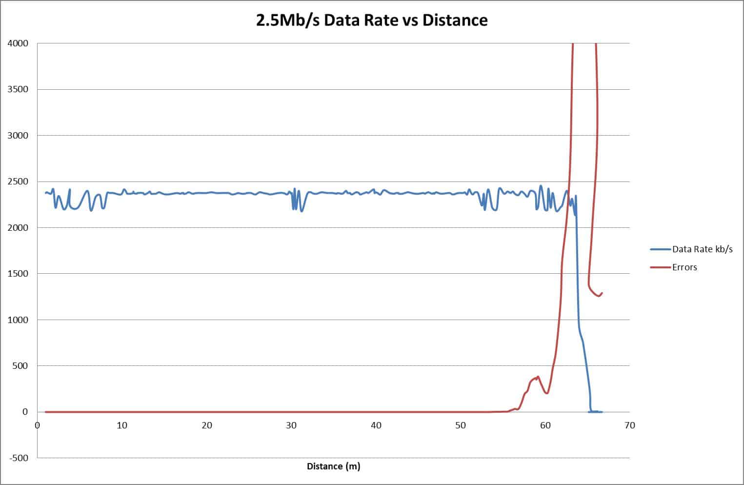
As explained above, the maximum operational distance is defined by both turbidity and ambient light. The below graph shows some practical data from a trial. Note the maximum range has been limited by both ambient light as the operations were at 2.5 m deep during the night and turbidity to 70 m. The graph shows how the data transfer performance changes over distance.
The blue line is the data rate between the two BlueComm 200s under test. As can be seen, it is constant and stable up to 60 m. At 60 m the number of photons being received gets close to the ambient light level. The system starts to struggle to distinguish between ambient light and the BlueComm transmission. The red line shows how the errors increase quickly at the maximum distance and the data rate reduces dramatically.
If you would like to find out more about our BlueComm, you can read more here.
If you would like to talk to us about how BlueComm could work for your next project, please get in touch.
Last week we introduced Mike Ellis, our (re)new(able) guy! Now it’s time to introduce the second of our recent new starters, Aidan Thorn. If you’re in marine robotics, you’ve probably already come across him. He’s joined us to help us further support the global energy transition, ocean science and defence through advanced underwater robotics as our Business Development Manager for Marine Robotics.
I’ve now been Sonardyne’s Marine Robotics Business Development Manager for three months. It’s been quite the whirlwind. I’m not long back from the Marine Autonomy and Technology Showcase at my previous haunt – the National Oceanography Centre (NOC). This was having also attended the Pathways to Autonomy event at London International Shipping Week and Ocean Business, all of which have been in person events (finally!), as well as hosting my first Sonardyne webinar. Each one reaffirmed why I took this exciting role and why now is such an exciting time for marine robotics. “Exciting” doesn’t feel like a strong enough word to describe what’s happening in our industry within marine robots.

When I came into the industry, more than 20 years ago, as an apprentice at the NOC, they had one autonomous underwater vehicle (AUV), the Autosub. When I had walked around my first Oceanology International in the very early 2000s, there were a few unmanned underwater vehicles (UUVs) and not an uncrewed surface vessel (USV) in sight. Times have definitely changed.
The prevalence of marine robotics
During MATS, the NOC celebrated 25 years of Autosub science missions and we were told of their ambitious plans to deliver increasingly complex science using marine robots. When I was walking the show floor at Ocean Business last month, it was very obvious how prevalent marine robots have become in marine operations, nearly every stand either referenced or actually had some type of marine robot featured somewhere. It’s also not just about AUVs, there are now “UxVs” in all shapes, sizes and capabilities on display and operating in our ocean.
One of the drivers, and a topic that no one could have missed over recent weeks, while COP26 was running in Glasgow, is climate change. It’s a significant driver across ocean going sectors, to the use of marine autonomous systems towards goals of reaching net zero carbon emissions.
[blockquote]”Where the focus for marine autonomy has historically been around getting into areas that are difficult/impossible to send humans or to remove humans from the dull, dirty and dangerous aspects of operating at sea, wider adoption is now being driven by their environmental benefits”[/blockquote]
Marine robotics no longer just exist for the experimental or difficult to reach operations. Replacement of heavy fuel burning ships for tasks like inspection, operation and maintenance of offshore infrastructure, data harvesting from subsea nodes and environmental impact assessment is increasing. Operations like autonomous logistics transportation are fast becoming a tangible reality.
So, it’s definitely an exciting time to be involved in the world of marine robotics. It’s great to see real-world applications of the technology, solving real challenges for users. But there are still vast challenges to solve before we will see all of the ambitious plans and conversations at conferences and exhibitions put into practise.
Collaboration around technologies, skills and regulation is needed to enable mass adoption and scale-up, as was recognised at London International Shipping Week’s Pathways to Autonomy event, and was also a theme in the questions from delegates at MATS. It’s helping to solve these challenges that makes me most excited about my new role here at Sonardyne.

Enabling marine autonomous systems
In terms of robotics, we enable marine autonomous system tracking, navigation, command, control and communication. Our equipment and systems are key enablers for the most exciting marine robotics developments and operations happening in our waters today, and into the future. That ranges from NOC’s latest under-ice AUV to Fugro’s Blue Essence and Blue Volta combined USV/electric remotely operated vehicle (ROV) combination, to Ocean Infinity’s Armada fleet – and that’s just scratching the surface. There are so many more companies and organisations that we’re engaging with on marine robotics projects that cut across our three core market areas: science, defence and energy.
As part of the wider Covelya Group, we have partnerships with incredible companies that provide imaging, machine learning and AI capabilities, ensuring that data is converted to useable information for end users.
But it’s not just about our equipment and systems. In an amongst all the events and meeting customers and users, I had the privilege of spending a week in Plymouth with the Sonardyne training team. The level of detail and care the team put into training users of our equipment to ensure they have the skills to operate it in real-world environments is inspirational. We’re already looking at how we can use this capability and experience to seed knowledge into the next generation of ocean technology operators. This is the generation that’s going to be operating and interacting with marine robotic and autonomous systems from day one.
Providing complete MAS solutions
We’re looking to provide a number of complete solutions. For wider adoption of marine autonomous systems (MAS) to take place, the market will need standardised operating methods. It’s my ambition that Sonardyne’s complete solutions set the standard for MAS command, control, tracking, navigation, positioning. We are not only interested in working with our group companies to achieve this, we are interested in engaging with all of you.
We want to build greater intelligence into our payloads so that they can identify and diagnosis their own faults or faults in the wider marine autonomous system. We are already doing things like building edge computing into our payloads to enable them to ensure that they’re feeding the pertinent data to the user in real or near real time. We are also collaborating with the likes of the UK’s Defence Science and Technology Laboratory (Dstl) and Thales, here in the UK, on secure methods of communications between robotic platforms to enable interoperability.
Either as a company, as a group of companies or in partnership with others, we are looking to provide solutions for the complete marine autonomous system, from packages that go onto the robot themselves to packages that help the robot to launch, be recovered, recharge, dock, transfer data and so on.
I’m looking to start those conversations now about how we can work with you to partner on integrations or to understand your operational challenges and help to solve them with you.
Author: Chris Hammersley – Applications Project Manager
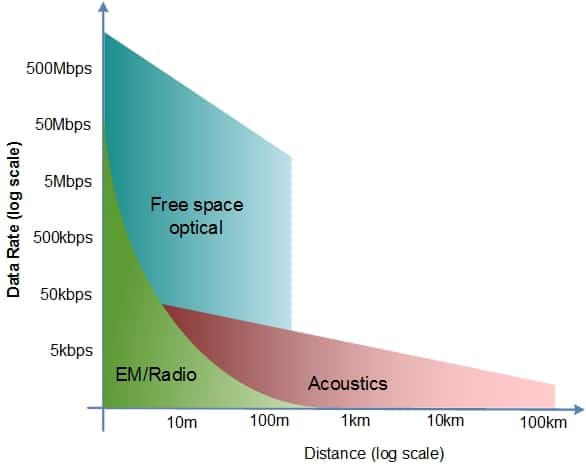
Water is an incredibly hard medium to communicate through. In air, we are all used to having almost unlimited data in our pockets and being able to stream the latest YouTube cat video at a moment’s notice. However, go just a few metres underwater and all that stops. Water absorbs, attenuates and tempers just about any signal travelling through it. This means for many years, subsea wireless communication has been limited to speeds which make a dial-up connection look fast.
For years, the market has concentrated on subsea acoustics development, because it was the only wireless technology available. Acoustics still provides the best operating range of any available technology, but at present the majority of deep water (3-4 km) acoustic modems are limited to around 5-10 kb/s while some short-range shallow water offerings can go up to 100 kb/s. Progress is being made in improving acoustic solutions, but the possibility of a Mega bit per second (Mb/s) acoustic link is still very much in the conceptual stages.
Underwater communications alternatives to acoustics
The subsea market has learned to live with such limitations, either tethering equipment or reducing the data sets to the absolute minimum for acoustic transmission. However, as technology advances, alternatives to the acoustic pressure wave are becoming a reality.
Our preferred alternative is free space optical communications. While mathematical models show the maximum theoretical communication distance is limited to several hundred meters, the possible data rates can be incredibly high, as shown by the current optical fibre speed record standing at over 1,000 Gb/s.
With recent improvements in silicon technology, high power LED technology and advanced optical sensors, it was possible to see how wireless broadband speeds might come to the subsea world. This research led to Sonardyne investing in subsea free space optical communication. Together with our partner Lumasys, we have been developing our BlueComm optical communications range.
As with any technology, there are trade-offs during the design between different performance criteria, which is why we now have a range of our BlueComms, each designed around a different maximum performance characteristic.
There are two versions of our BlueComm 200 available, operating at different wavelengths.
BlueComm 200
BlueComm 200 operates using visible light. Visible light can travel significant distances through water meaning that BlueComm 200 has a range of up to 150 m. This makes it an excellent tool for wireless transfer of video and direct control of a vehicle in AUV applications. It is also ideal for data harvesting applications. Using BlueComm 200, an AUV or ROV can transfer large volumes of data up to ten thousand times quicker than acoustics.
BlueComm 200 UV
BlueComm 200 UV works just like BlueComm 200, however it uses a shorter wavelength in the ultra-violet spectrum. This means that it can operate even in the presence of artificial lights. Operating in the UV spectrum, BlueComm 200 UV can work at ranges of up to 75 m. It is best suited for ROV or AUV applications that require the use of lights, for example, when recording video.
Underwater communication with lasers
We also developed a variant that uses two rapidly modulated off-frequency lasers to produce simultaneous bi-directional communications. The equipment is optimised for peak data transfer performance with transfer speeds of 500 Mbps being achievable. This is excellent at large data offloads from deployed sea bed nodes or fast ‘fly-by’ data collections by field resident AUVs.
If you would like to find out more about our BlueComm, you can read more here. Or read our blog about the science behind BlueComm here.
If you would like to talk to us about how BlueComm could work for your next project, please get in touch.
We’ve had some new starters in our business development team here at Sonardyne over the past couple of months. They’ve joined to help us further support the global energy transition, to further ocean science and support advanced underwater robotics. We thought it was time we introduce them. First up is Mike Ellis, our new Business Development Manager for Offshore Renewables.
Well, it’s only been a few weeks, but it already feels like longer – in a good way!
I didn’t have to give joining Sonardyne too much thought, especially in a role that is going to help me play a part in the energy transition, changing how we use our planet’s resources. It’s a subject that’s become increasingly close to my heart in recent years, as it’s become clear that we need to transform our energy system, for us and future generations. The proliferation of offshore renewable projects, and the change that comes with that, brings about new and evolutionary technological requirements, such as autonomous platforms and the harvesting and automation of big data. It’s a critical, but also exciting space and one that’s set to grow immensely over the coming decades.
Much of my adult life has always been in and around marine activities. It all started after I got into diving while backpacking in my early 20s. Seeing the Great Barrier Reef, sites in Southeast Asia and the Red Sea got me hooked on the ocean. I wanted to work in an industry based around oceanic activity, but also give me a relatively good income. So, I became a hydrographic surveyor and I’ve never looked back.
It’s a career that has taken me around the world, including wreck hunting using advanced multi-beam systems and technologies like the Hugin autonomous underwater vehicle, when it was still a new piece of kit in the surveyor’s toolbox. After several years focused on survey operations with Fugro and Gardline, I joined EMGS in the late 2000s; a Norwegian company that made big waves in the oil and gas exploration sector with their advanced marine electromagnetics proposition. In more recent years I have taken on more business-focused roles, working with younger companies, including the implementation of automated data acquisition using robotics into the offshore renewable sector.

For a while now, I have wanted to make a bigger impact in renewables, not least offshore wind. Sonardyne has been ubiquitous throughout my professional career and while a large part of that has been oil and gas focused, Sonardyne’s systems are omnipresent in supporting work in offshore renewables. Whether that’s in navigation and positioning systems for survey, construction, and inspection operations; sensing, imaging and monitoring during consenting and operations and maintenance phases; or wireless communications and remote operations, for data-harvesting or communicating between autonomous platforms. Now that I’m part of the team, I’m enthusiastic to see that the renewables industry is increasingly investing in these technologies as key ways to help improve reliability, efficiency, mitigate HSE and operational risks, and reduce levelized cost of energy (LCOE).
I also see some particular challenges the industry has to face, both across fixed bottom wind farms and, as it emerges to a commercial offering, floating. For example, cables and their protection systems have challenges. Ensuring cables remain in useable condition over 25-30 years is all about understanding how they’re effected by the dynamic environments they’re in. We need to acquire bigger data sets, yet gain more value from analysis tools, including digital twins.
These are just a few of the discussions I’ve been hearing in my first few weeks at Sonardyne. It’s been a bit of a whirlwind since my start in late September. I’ve visited both Global Offshore Wind event in London, chatting to developers and the supply chain about their needs, and Ocean Business, where I met customers and industry colleagues. I’ve also been able to enjoy a week at our training and testing facilities in Plymouth, getting on the water and getting hands on some of the latest Sonardyne systems.
I’m also looking forward to working with our sister Covelya Group companies – EIVA, Voyis and Wavefront. All these companies harness multi-application marine products, including advanced survey and processing software and underwater imaging. Integrating these with our positioning and navigation technologies has already proven to be hugely advantageous, creating enhanced solutions – reducing integration complexity while improving data – and I can only see further opportunities for these.
What’s most exciting is that, for a majority of the subsea challenges out there in the offshore renewable sector, we at Sonardyne, and the wider Covelya Group, will have the solutions.
Underwater obstacle avoidance technology from maritime defence technology companies Sonardyne and Wavefront Systems has been successfully demonstrated on board an extra-large, uncrewed, underwater vehicle (XLUUV) built and operated by Plymouth-based MSubs.
The demonstration of the Vigilant forward looking sonar was part of the first phase of the UK’s Defence and Security Accelerator’s (DASA) ‘Uncrewed Underwater Vehicle Testbed – Opportunity to Integrate’ competition, run jointly with the Royal Navy and the Defence Science and Technology Laboratory (Dstl).
The DASA competition is focused on testing and validating commercial-off-the-shelf technologies (COTS) sensors and payloads, like Vigilant, to help the Royal Navy understand the future roles for XLUUVS for surveillance, reconnaissance and anti-submarine warfare, and deliver new capabilities to the Royal Navy years earlier than otherwise be possible.
Vigilant, developed by Wavefront Systems and manufactured and commercialised by Sonardyne, is a navigation and obstacle avoidance sonar for ships, uncrewed surface vessels (USVs) and underwater vehicles. It provides crews with automated long-range detection of objects in the water column, showing them where it is safe to navigate and alerting them to potential underwater dangers that could result in a collision or grounding.

The system has two operating modes. In 3D mode, Vigilant produces accurate 3D bathymetry and colour-coded depth imagery out to 600 m and to depths down to 100 m. In Sonar mode, Vigilant processes the intensity of the acoustic data to extract long-range positional data out to 1.5 km and over a 120-degree field of view. The sonar returns are used to generate alerts highlighting the presence of a navigationally relevant obstacle.
For the trial, the system’s sonar projector and receiver array were mounted in the bow of the 9 m-long MSubs’ S201 XLUUV. At just 31 cm-wide and weighing only 14 kg in air, Vigilant is easy to retrofit on a wide range of platforms including ships, USVs or, as in this case, an XLUUV.
As part of the demonstration, the XLUUV was programmed to travel beyond the breakwater outside Plymouth sound. Vigilant was used to create a bathymetric map that was used by the XLUUV to navigate. The data was also overlaid over existing charts of the area, demonstrating the higher resolution provided by Vigilant.
Ioseba Tena, Head of Defence at Sonardyne, said: “We’re delighted to be playing a role in helping the Royal Navy and programme partners to test and evaluate technologies that will help the UK stay ahead of her adversaries in the underwater battlespace.
“Seaborne collision avoidance is a vital consideration for autonomous and uncrewed naval platforms. Vigilant can be integrated into these ocean robots to provide essential information to autopilots and command and control systems, to aid safe navigation and manoeuvres around hazardous obstacles.”
[blockquote author=” Bret Phaneuff, Managing Director at MSubs”]”The data from Vigilant is truly impressive and transformative. It provides our XLUUV with instant situational awareness, which will help it avoid obstacles and, with some further integration, help optimise navigation trajectories to improve our performance and increase our endurance.”[/blockquote]
Subsea technology specialist Seatronics has been announced as the first customer for Sonardyne’s new SPRINT-Nav Mini Navigator, launched just one week ago.
Seatronics has purchased the technology, the world’s smallest hybrid acoustic-inertial navigation instrument, for its VALOR remotely operated vehicle (ROV), itself designed to be the smallest, most powerful and capable inspection class ROV in its category.
SPRINT-Nav Mini Navigator will provide VALOR with accurate, precise and robust navigation and control, supporting Seatronics in its goals to further extend the boundaries of remote operations with tasks ranging from underwater inspection in lieu of dry-docking (UWILD) through to mine identification and destruction.
SPRINT-Nav Mini combines an INS, AHRS, pressure sensor and DVL in a single subsea housing depth rated to 300 m or 4,000 m and weighs as little as 3.6 kg in air. The new Navigator variant extends the capability of the Guidance model introduced in 2020, by calculating and providing the position of a remote, autonomous or piloted underwater vehicle, or uncrewed surface vehicle, in addition to its velocity, depth and attitude.
The cost and complexity of integrating third-party sensors is a key consideration for robotic vehicle builders and owners. SPRINT-Nav Mini addresses these needs with a compact, all-in-one design that requires only one cable connection, is supplied with a full integration guide, and is cheaper than the separate sensors it replaces. And unlike other MEMS-based sensors, SPRINT-Nav Mini’s performance is not impaired by magnetic interference when operating close to structures such as an underwater dock.
VALOR already offers an advanced capability for its size, with a 40Gbp MUX capacity allowing it to accommodate the most modern, high bandwidth survey sensors. Equipping it with SPRINT-Nav Mini Navigator further differentiates it from similar-sized platforms, providing a significantly more flexible, configurable inspection platform that can undertake a variety of tasks that would typically be associated with much larger ROV systems.
[blockquote author=” Derek Donaldson, Seatronics’ Group Managing Director”]”Specifying payload sensors for a vehicle like VALOR often requires a trade-off between accuracy, performance, price and ownership. SPRINT-Nav Mini offers both the survey positional accuracy our clients are looking for, and a small form factor that we can fit and put straight to work. Another key reason for investing in SPRINT-Nav Mini is our ongoing relationship with Sonardyne. We knew that we would be fully supported in our concept to push the boundaries of remote operations from a small ROV solution by the Sonardyne team. This is critical when adopting new technology for a new platform”[/blockquote]
Jose Puig, Regional Sales Manager, Asia, at Sonardyne, says, “VALOR has been designed to be a versatile platform in terms of its operability, including remote operation, over-the-horizon control combined with supervised autonomy for enhanced inspection experiences. SPRINT-Nav Mini Navigator will support those operations, whether that’s from a quayside, vessel or uncrewed surface vessel (USV), providing a flexible solution to Seatronics’ customers.”