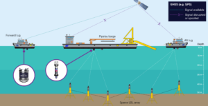
A shallow-water pipelay project in the Middle East is set to demonstrate how to keep construction spreads working and accurately positioned during GNSS disruption.
UTEC, Acteon’s geo-services business, will use a hybrid acoustic-inertial positioning spread from Sonardyne, a Kraken Robotics company, to support pipelay barge and anchor-handling tug operations across two projects.
The work, spanning more than 150 km of pipeline installation, will take place in water depths of less than 50 m, where shallow-water spreads need dependable positioning for both the barge and support tugs, while reducing reliance on increasingly disrupted GNSS.
“The challenge is familiar to many offshore contractors working in regions where interference, denial and spoofing of GNSS signals – often the primary positioning reference for operators – are becoming operational realities,” explains Nadir Rahmatullah, Vice President Asia Pacific and Middle East at UTEC.
“Pipelay barges must be moved precisely as pipe is installed, while support tugs need reliable position data as they run and manage anchors around the construction spread. Any loss of confidence in positioning can affect efficiency, safety and schedule.”
Developed with Sonardyne, UTEC’s solution combines Fusion 2 LBL-INS survey software, Compatt 6+ LBL transponders and SPRINT-Nav navigation systems to provide resilient positioning for shallow-water construction operations.