Sonardyne
Support Centre

Case Study:

Energy Blog

Author:

Elaine Maslin

The evolution of Sparse LBL (range-aiding): less is more in subsea positioning  

16012026

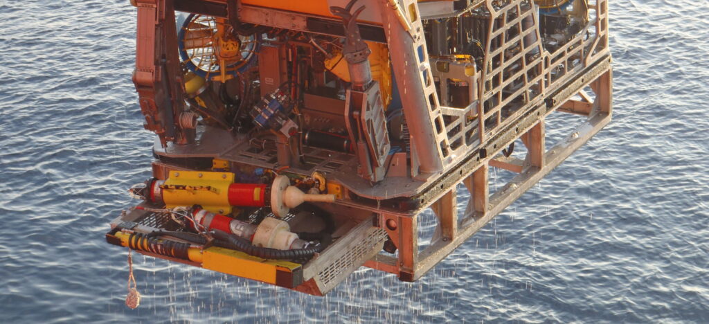
Accurately positioning objects underwater has always been one of the greatest challenges in marine operations. Whether it’s tracking a remotely operated vehicle (ROV) thousands of meters below the surface or installing critical subsea infrastructure, knowing exactly where things are is essential.

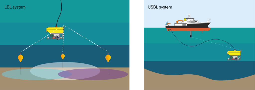
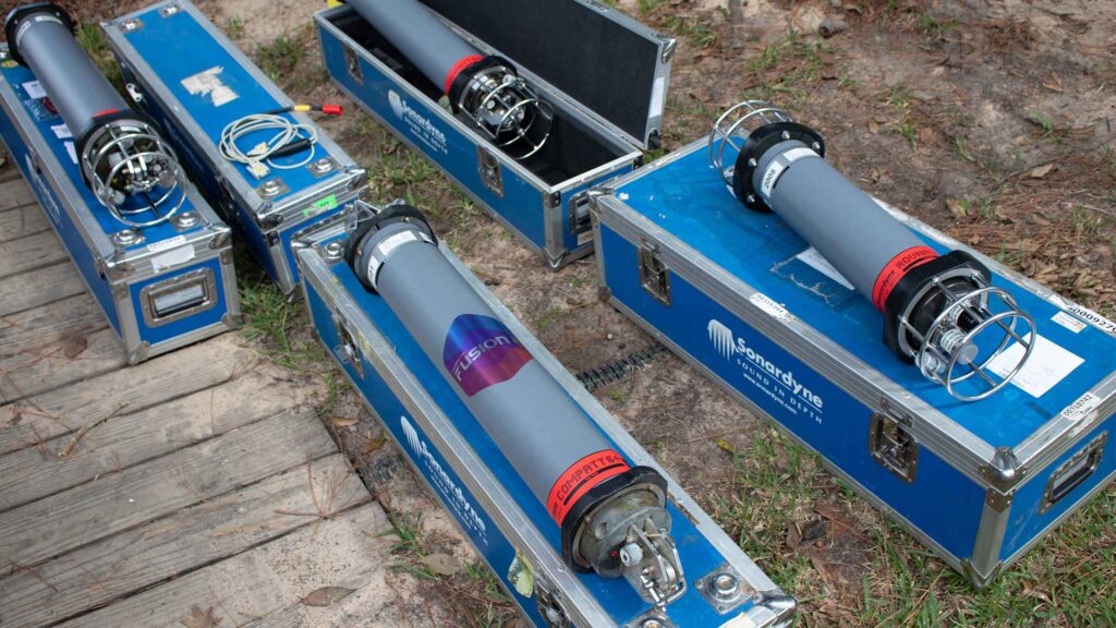
For decades, this capability relied on two primary acoustic positioning techniques: Long BaseLine (LBL) and Ultra-Short Baseline (USBL). While LBL offered exceptional accuracy independent of water depth, it demanded dense, time-consuming arrays of seabed transponders.

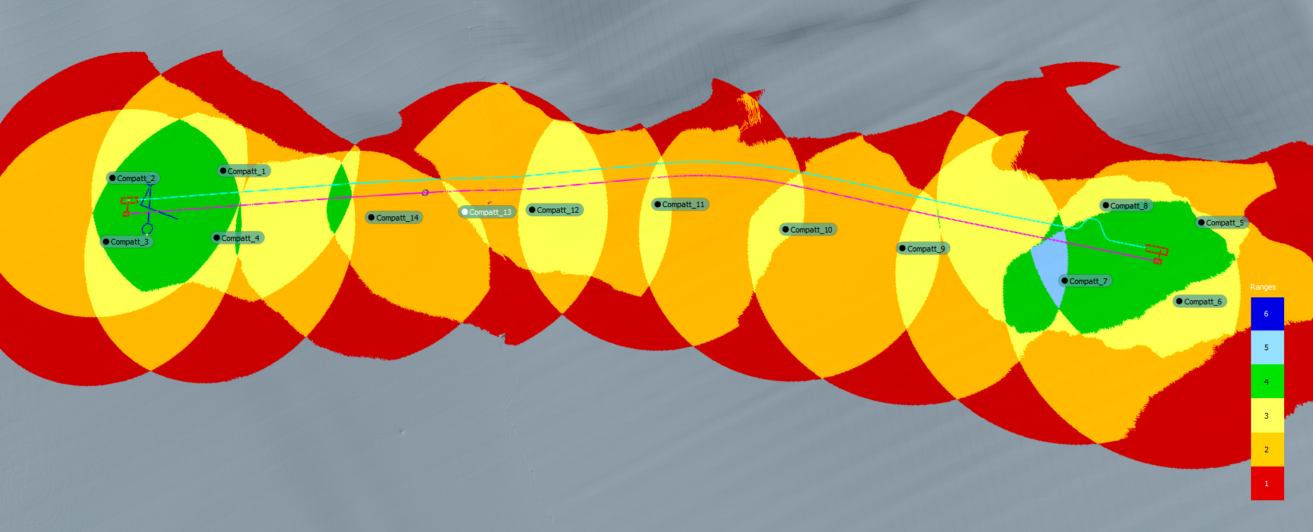
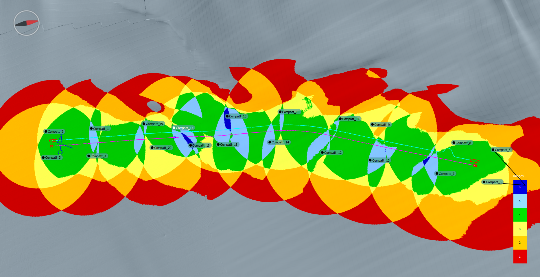
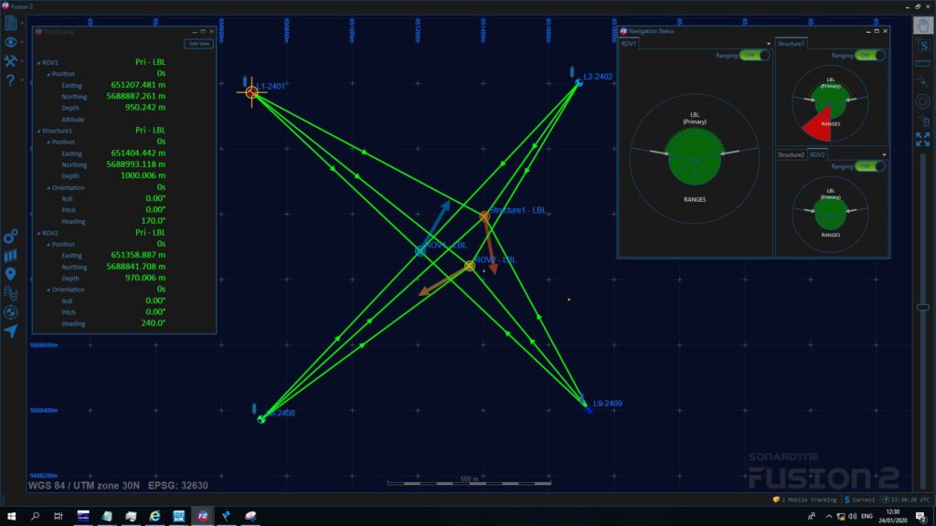
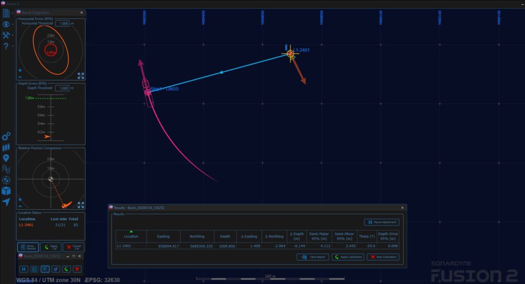
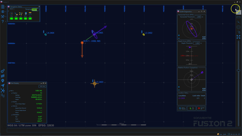
USBL provided speed and flexibility but faced accuracy limitations in deep water and challenging acoustic conditions. This operational gap created the ideal environment for a hybrid approach to emerge—Sparse LBL (which our surveyors would be happier calling range aiding).

It’s an approach that Sonardyne played the leading role in developing, making it the firmly established practice it is today. In this article, we explore the history of range aiding (Sparse LBL), tracing its emergence from a conceptual to a commercial solution by the early 2010s, into an industry standard and further advances like SLAM calibration.

We will look at the technological enablers that made it possible and consider its impact on efficiency, integrity and cost-effectiveness in modern offshore operations.

A tale of two baselines: classic LBL and USBL 

Before the development of range-aiding, operators chose between two distinct acoustic positioning techniques. 

Classic LBL

LBL systems calculate a target’s position by measuring ranges to a seabed array of four or more acoustic transponders. Because LBL relies solely on range measurements, its accuracy is not degraded by water depth.

However, deploying and calibrating these dense arrays—often 100 or more transponders—demands significant vessel time and cost, making it less suited to short-duration projects or dynamic tasks.

USBL

On the other hand, USBL systems determine position by measuring range and bearing from a single, vessel-mounted transceiver to a subsea transponder. This enables rapid mobilisation.

The trade-off is that accuracy, as a percentage of slant range, decreases with depth. USBL can also be affected by acoustic conditions, vessel noise and the long laybacks seen in deepwater operations.


The need for a middle ground 

By the early 2000s, the offshore industry was pushing into deeper waters, with greater demands for both precision and operational efficiency. Under these conditions, both LBL and standalone USBL operations had limitations.


  • Cost and time: Deploying, calibrating and recovering dense LBL arrays for pipelay operations, structure installation or metrology was an economic barrier.
  • Deepwater challenges: Standalone USBL struggled to deliver the required accuracy and integrity for critical tasks in depths exceeding 1,000 m.
  • Acoustic congestion: Busy fields increased the risk of acoustic interference between different positioning systems. The introduction of inertial navigation systems (INS) extended the operating range of USBL, but was still limited by the absolute accuracy of USBL systems.

Operators needed a new approach.

The idea of sparsity: from dense arrays to minimal transponders 

Sonardyne pioneered the development of range aiding as a practical solution for these challenges. The guiding idea was to achieve LBL-grade integrity with a minimal number of transponders by combining short-term INS precision with LBL integrity.

Instead of dense seabed grids, the engineering and survey team at Sonardyne showed that, with this set up, you could operate with just two or three transponders.

This innovation wasn’t seen as a replacement for classic LBL in every application. Its strength was the ability to augment and stabilise INS drift with ranges to seabed transponders, hence the term range aiding.

A classic set up would see a simple triangle of seabed transponders enabling an INS fitted to a subsea vehicle to constrain drift using pure range measurements, whilst also evaluating the USBL system as an error check.


The technological enablers

It sounds simple. Yet, the ability to work with sparse arrays was only possible due to a sequence of key innovations—several of which were developed and introduced by Sonardyne.

First, let’s go a bit further back in history. Use of acoustic aiding for underwater platform positioning and navigation had already been introduced in the 1980s, through Sonardyne’s ROVNav. It was – and still is – an ROV transceiver, developed to increase ROV tracking accuracy for operators like Shell. It could interrogate an LBL array and send the range data to a positioning computer on the vessel, hugely improving the best accuracy at the time, leading to improved accuracy surveys.

Another innovation came in the early 2000s, to support the – at the time – emergent world of autonomous underwater vehicle (AUV) navigation. Sonardyne developed the Av-Trak transponder/transceiver for use by early pioneers like Denmark’s Maridan (one of their AUVs is pictured below) and US-based Bluefin Robotics. AvTrak (now AvTrak 6) allowed their AUVs to range to seabed transponders and receive USBL position updates from a support vessel, to correct their INS drift for high accuracy navigation.

A Maridan AUV being launched over the side of a ship in calm waters.

Introducing Wideband 2 and inertial aiding 

The main enabler for range aiding, was the introduction of Sonardyne’s Wideband 2 signal architecture in our 6G hardware (launched in 2010 at Oceanology International), alongside our Lodestar AHRS high grade subsea aided INS (introduced in 2007), around which our SPRINT INS platform was built.

The SPRINT (Subsea Precision Reference Inertial Navigation Technology) platform tightly coupled INS with our industry standard LBL platform, which was Fusion 6G at the time.

SPRINT could provide navigation for an ROV in Sparse LBL mode by using the ranges from one or more seabed deployed transponders, with known positions, to constrain error growth in the absolute position output.

As the ROV was reliant on far fewer range observations, it was important that those ranges were as reliable as possible. Wideband 2 signal architecture in our 6G hardware enabled this, with built-in diagnostics to tell SPRINT whether the ranges were good or should be rejected, to maximise the integrity of Sparse LBL INS operations.

Wideband 2 also enabled multiple users to operate in the same acoustic band without interference and facilitated fast, robust transponder calibration.  “Piggybacking” on existing seabed infrastructure or sharing sparse arrays between vessels also became feasible—greatly reducing deployment time.


A sparse set up

As with a conventional LBL setup, the vehicle was fitted with a ROVNav acoustic transceiver. Communications up to the vessel were routed via the SPRINT – acting as both a multiplexer and accurately time stamping the acoustic range data.

In addition to LBL acoustic aiding, SPRINT also provided the ability to use vehicle-mounted aiding sensors such as Doppler velocity logs (DVL) and pressure/depth sensors to further improve the precision, accuracy and reliability of the navigation solution.

The addition of DVL aiding into SPRINT provided the ability to “ride-through” loss of acoustic aiding (USBL or Sparse LBL) without significant degrading of performance over given time periods.

A SPRINT-equipped ROV returns to the surface after recovering a Sparse Long BaseLine transponder array.

A SPRINT-equipped ROV returns to the surface after recovering a Sparse Long BaseLine transponder array.

A subsea Lodestar INS unit awaits final installation on an ROV.

A subsea Lodestar INS unit awaits final installation on an ROV.

A ROVNav 6 LBL transceiver.When configured for Sparse LBL operations, the ROVNav is connected directly to the Lodestar unit, receiving power, communications and very accurate time stamping.

A ROVNav 6 LBL transceiver. When configured for Sparse LBL operations, the ROVNav is connected directly to the Lodestar unit, receiving power, communications and very accurate time stamping.

Early trials and adoption 

One of the first real-world uses of range-aiding, or Sparse LBL, was in 2011, on a vessel working in 1,100 m (3,630 ft) water depth, outlined in a 2012 issue of Baseline.

During this operation, the horizontal difference between the full and Sparse LBL tracking solution was just 12 cm with SPRINT using aiding from a single Compatt 6 transponder for ranging with a baseline distance of 300 m.

Range aiding quickly found application in inspection, maintenance and repair (IMR) and light construction. ROV support vessels used two or three seabed transponders, evaluated against USBL tracking, empowering teams to work confidently near structures even in deep water.

The method was also adopted for vessel dynamic positioning reference—a sparse array providing the DP system with stable, depth-independent position data. This offered a valuable alternative or back-up to GNSS, particularly during operations near infrastructure that could compromise satellite signals.


Sensor Fusion

Another improvement came in 2017 with the launch of SPRINT-Nav.  To work effectively in a Sparse array, range aiding relies on combining an INS with acoustic ranging.

SPRINT-Nav made this even more efficient by bundling the SPRINT INS, a DVL (providing additional acoustic aiding), and a high-accuracy pressure sensor into a single compact and pre-calibrated housing.

This reduced hardware interfaces and mobilisation time, while also leveraging tight integration to achieve better results than could otherwise be had from using separates.

A Fusion 2 screen showing structure touchdown

Fusion 2 screen showing structure touchdown

A Fusion 2 screen showing a box in

Fusion 2 screen showing a boxin.

Fusion 2 – even more with even less

While this new more efficient capability had been unlocked, it was still complex, it needed separate software applications, vessel hardware and often complex communication interfaces.

Sparse LBL operations helped to reduce how many transponders were needed in a positioning array and how long it took to set up. But, two different sets of software, that need to talk to each other, were needed.

Launched in 2018, and built from the ground up, Fusion 2 removed these barriers. It provided, for the first time, a single, unified solution surveyors could use for LBL and LBL-aided INS operations, making set up easier, reducing hardware and software needs and removing interface complexity.

While SLAM calibration could already be done, Fusion 2 introduced the ability to run real-time SLAM calibration for Spare LBL or range aiding operations. This meant you could do your SLAM calibration while you survey, significantly reducing survey time.

In 2019, Fusion 2’s real-time SLAM capability helped i-Tech 7 reduce the number of Compatts it needed for a pipeline installation array in the US Gulf of Mexico by 50-66%. Learn more here.


Wideband 3 – faster, more efficient data

The release of Fusion 2 coincided with Sonardyne’s latest Wideband digital signal processing protocol, Wideband 3. This brought 1Hz update rates and the ability to get sensor data at the same time as navigating ranging data. 

Operators could now get real-time positions and sensor data simultaneously, accelerating update rates by a factor of 10 and eliminating latency issues. Wideband 3 made its appearance visible with a + sign on the 6G instruments upgraded to deliver it, such as Compat 6+ and ROVNav 6+. 

Standardisation and best practices 

As range-aiding spread, Sonardyne drove the establishment of industry best practices.


  • Array design and geometry: Optimising array geometry and transponder placement became critical, with planning tools and guidelines informed by field experience and data analysis.
  • Quality control (QC): Real-time QC metrics became standard. Sonardyne’s software platforms offered operators robust indicators of position quality—error ellipses, observation residuals, statistical measures—enabling transparent assessment of reliability for users and the end customer.

The operational impact

Range aiding, or sparse LBL, as a technique has spread globally, from the North Sea to Brazil.

Shaped by Sonardyne’s ongoing development, it’s delivered transformative benefits for offshore operations helping to reduce vessel time and cost.


  • Mobilisation speed: Using minimal arrays—or existing field beacons—reduced mobilisation and calibration times substantially.
  • Reduced hardware requirements: Array plans could cut Compatt numbers by more than 30%.
  • Enhanced integrity: The additional layer of redundancy by evaluating USBL as well, providing a critical independent check on position for risk management in complex tasks.
  • Extended battery life: Lowered update rates for seabed transponders, especially when paired with INS, lengthened battery endurance and service intervals.

Learn more: How sparse is a sparse LBL array?

Going remote with ROAM

What’s more, since 2021, it’s also become a remote capability, using Sonardyne’s ROAM (remote operations access module).

This enables Sonardyne surveyors, in the UK or any of our offices, to support customers’ operations from wherever they are.

It was a direction of travel the industry was taking, albeit slowly. But it was a major benefit during travel restrictions imposed by the Coronavirus pandemic, allowing construction companies to de-risk operations.

Read more: Sonardyne delivers Fusion 2 remote operations first

What’s next: the future of hybrid positioning 

Sonardyne has made range-aiding an industry standard and the principles it delivers continue to guide innovation. Today, tightly coupled solutions blend USBL, LBL and INS, extending the legacy of Sonardyne’s work.

Sensor fusion is still delivering new benefits, such as through our latest SPRINT-Nav development – SPRINT-Nav DP.

SPRINT-Nav DP is a dynamic positioning (DP) reference system leveraging the hybrid acoustic-INS capabilities of SPRINT-Nav to provide a robust, independent DP position reference alternative, especially in GNSS-denied or shallow water environments where GNSS signals may be unavailable, spoofed or distorted.

As the use of uncrewed surface vessels (USVs) and AUVs continues to grow, the need for reliable, efficient hybrid positioning is more critical than ever.

The range-aiding philosophy—using less hardware to achieve greater integrity—remains foundational. Our developments in this field continue to help shape the future of underwater operations.

Planning makes perfect – considerations for Sparse LBL

Whilst Sparse LBL can provide positioning performance similar to full LBL with far fewer transponders, careful consideration of survey planning is needed to achieve optimum system performance.

There is less acoustic range redundancy than with full LBL and therefore systematic errors can be difficult to detect. For this reason, those considering Sparse LBL should consider the following critical elements:


  • Robust acoustic ranging performance regardless of acoustic conditions
  • Correctly calibrated Sparse LBL transponder positions
  • Accurate sound velocity measurement
  • Depth control of both the ROV and the sparse LBL calibrated transponder position/depth measurement
  • Tidal corrections – autonomous logging of pressure, temperature and speed of sound

Via our Technology Services group, we have been designed LBL arrays for over 15 years for well over 300 field developments. Our in-house tools allow detailed planning, analysis, simulations and calibration plans to be produced.

Dive deeper with our training videos