Hunting for wrecks can be a challenging exercise, especially when only an approximate location is known and a wide area of seabed has to be searched. Even then, you need highly trained operators to interpret the sonar data and determine if a target is of interest or not.
A major reason for this is that, often, low frequency sonar systems are selected in order to achieve a wide swath. That means targets of interest can be missed because they just don’t offer the resolution needed. Selecting a sonar with a wide swath can also result in shorter deployments when using an autonomous or unmanned underwater vehicle (AUV/UUV), not because they cover larger areas but because they need more energy.
Wide swath, high resolution
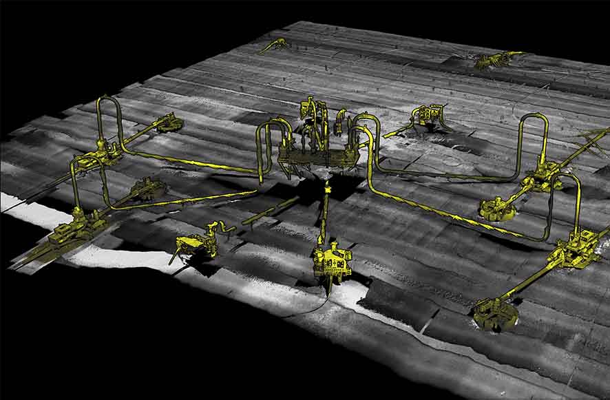
One of the advantages of using our Solstice side scan sonar is that you get a 200 m swath at high frequency resulting in a high area coverage rate and resolution that’s so good even an untrained eye can determine if a target they’re looking at is the wreck you’re hunting for.
A General Dynamics demonstration using a Bluefin-12 UUV integrated with a Solstice MAS for the Royal Australian Navy (RAN) is a great example of this capability. During sea trials, as part of the RAN’s SEA 1778 Program to develop mine countermeasures, the Solstice data located the 1944 wreck of the USS YF-415.
General Dynamic’s Greg Jennings explains: “We initially found the USS YF-415 while performing acceptance testing with our SEA 1778 customers from Thales and the Royal Australian Navy. We were required to demonstrate the 24 hours endurance of the Bluefin-12 and chose to perform a large survey in an area where there were charted shipwrecks, in hopes of finding something interesting. When we came back to shore Monday evening and reviewed the data, I was stunned to find this beautifully intact wreck in a location where no wrecks were charted. The team was particularly excited about the find because we were really interested in capturing imagery of a shipwreck.”
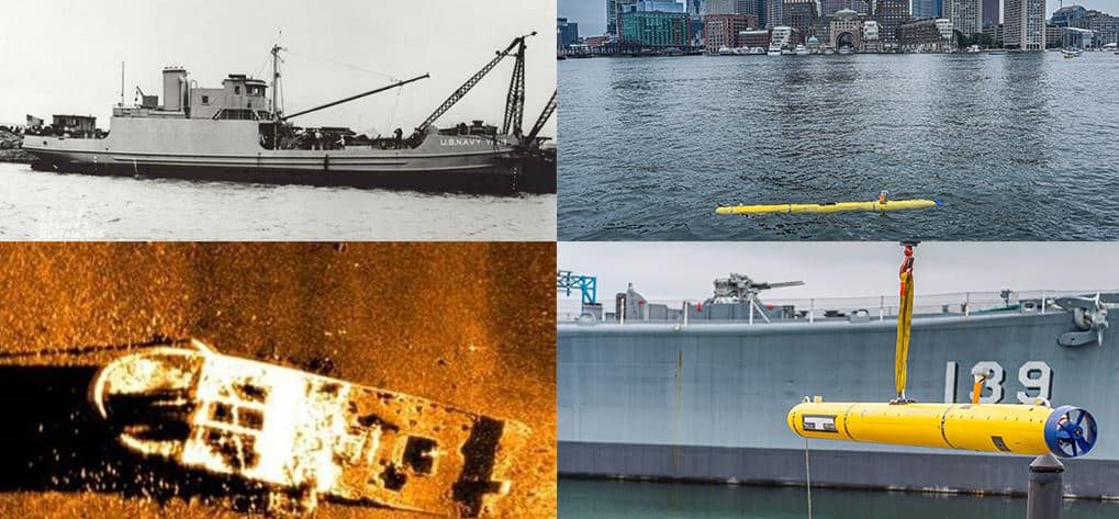
In the following days, the team spent some more time logging the position of the wreck and searching other known wrecks in the area. It wasn’t until several weeks later, after Jordan Corbin, the Program Manager, contacted the Massachusetts Board of Marine Archeology, that they learned that it was the USS YF-415.
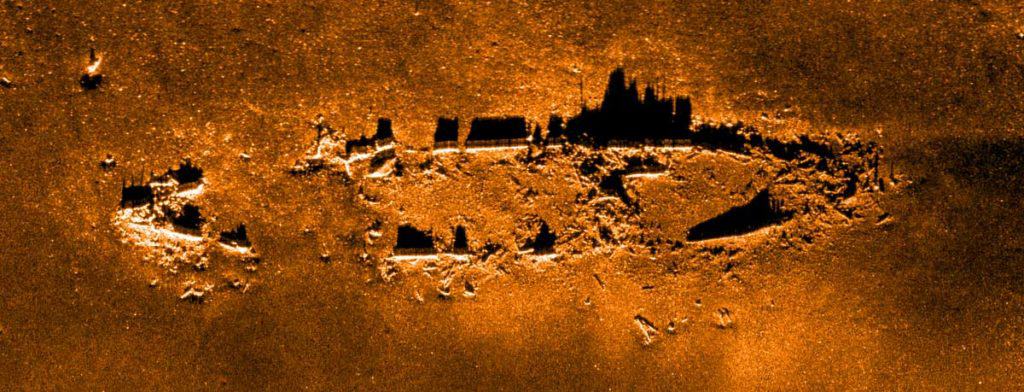
It was a sobering discovery. The USS YF-415, now resting in 240 ft water depth near Boston Harbor, was a type of barge used to transfer goods. In 1944, the vessel was conducting a routine obsolete ammunition dump when signal flares caught fire and ignited shells, leading to a series of explosions that sank the ship.
“The story really hit home for me because the ship had left dock just across the Back River from my home. It was quite sobering to learn of the tragedy behind the wreck. I hope that the families affected can find some solace in the beauty of the wreck. The imagery also shows large schools of fish surrounding the wreck, demonstrating how the sea has turned this gravestone into a monument to life.”
Side scan sonar for endurance UUVs
Solstice has been the multi-aperture sonar (MAS) of choice for General Dynamic’s Bluefin-12 since 2014 and is now also factory fit as standard on the Bluefin-9 as well.
The Bluefin-12’s offers long-range endurance, being able to run for 24 hours. The integration of our Solstice MAS, and on-board data processing features were key to the demonstration for the RAN. Its capabilities enable the Bluefin-12 to successfully provide ample mission-time and effective data collection and processing, yielding important information to help any team using it to assess and refine their mission. It also meant that the General Dynamics team were able to discover and enable the identification of the USS YF-415.
Ideal also for towfish
But while Solstice was initially designed for integration into UUVs, for wide area, high resolution mapping, whether that’s for survey, search and salvage, environmental monitoring or unexploded ordnance (UXO) survey operations, it’s also great from other platforms including towfish, as we demonstrated in a joint project with another Covelya Group company, EIVA. We trialled Solstice onboard EIVA’s ScanFish 3D remotely operated towed vehicle (ROTV), with great results, as you can see below.
With our SPRINT INS (inertial navigation system) onboard, and tracking using our Mini-Ranger 2 USBL system, it proved to be a real alternative to traditional synthetic aperture sonar (SAS) systems. Read more about the ScanFish 3D with Solstice here.
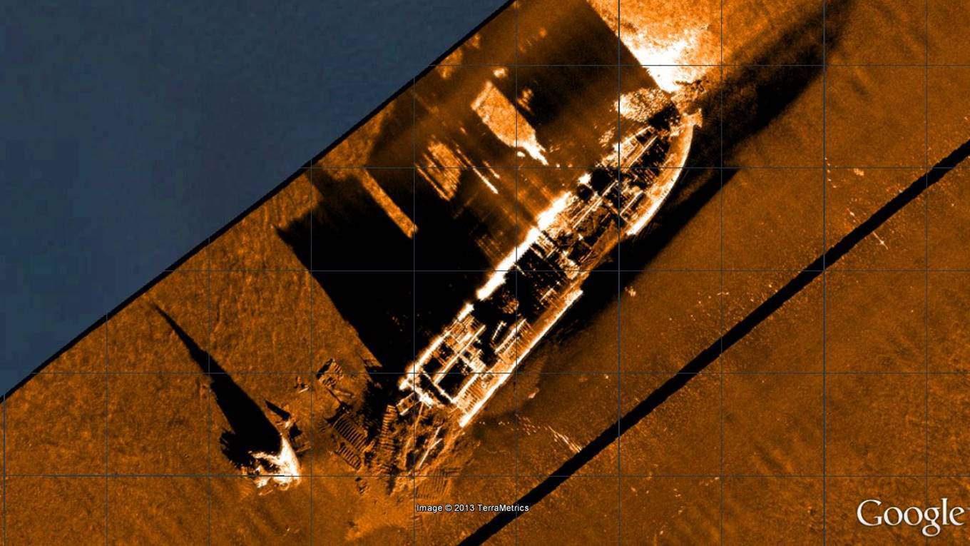
We’ve also deployed Solstice from our trials’ vessel, Echo Explorer. While not ideal – mounting the sonar from a vessel couples it to the sea surface, so it’s a harsh test – we’ve still gathered some superb imagery of wrecks, including the US liberty ship James Egan Layne, which was hit by a torpedo from a German U-boat near the Eddystone reef. Attempts were made to tow her ashore, but her stern collapsed causing her to sink.
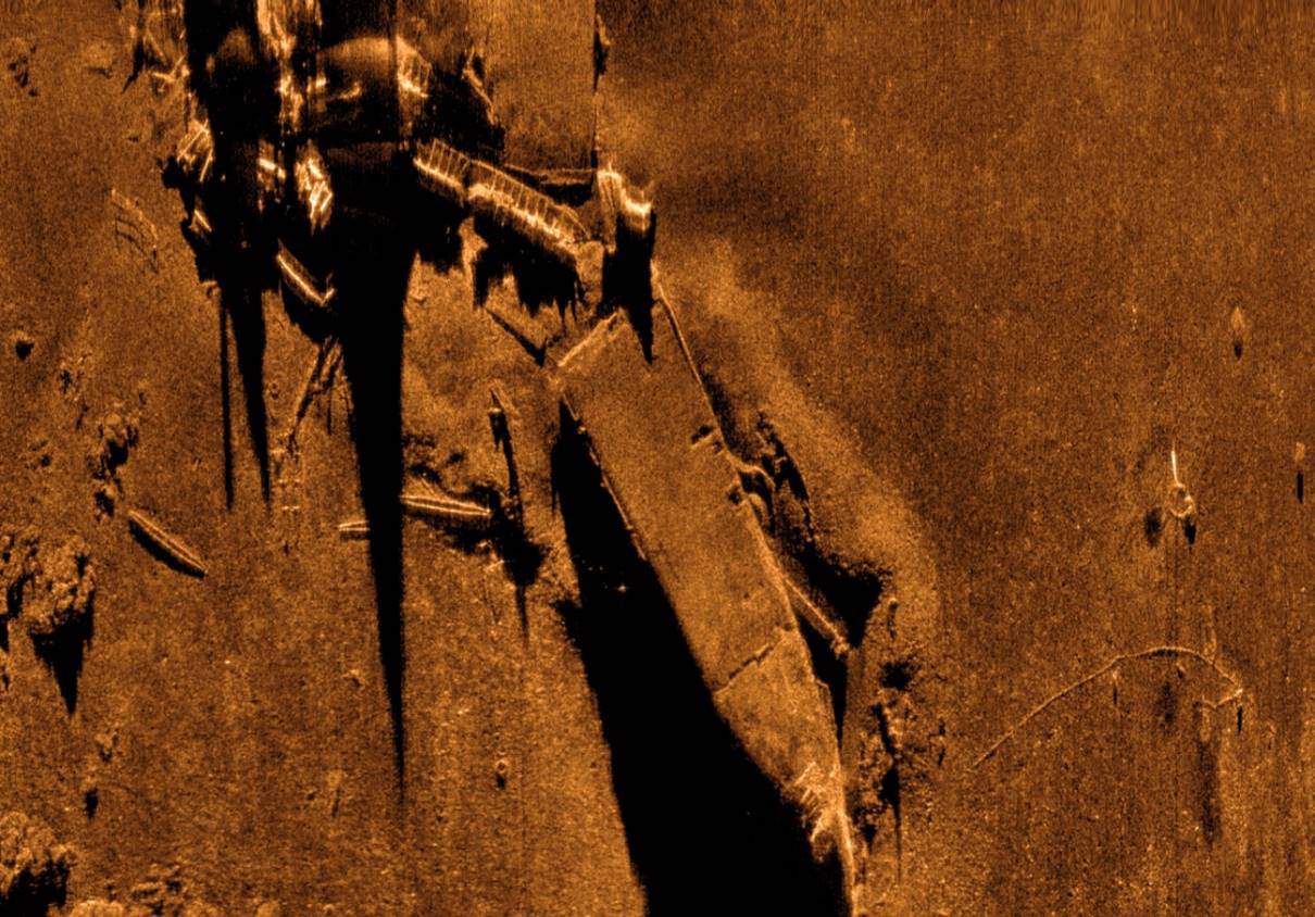
We also really like this imagery of the MV Fylrix, a general cargo ship which was towed and anchored in Jennycliff Bay, near Plymouth, after suffering severe listing, before eventually sinking. The vessel was irrecoverable and ended up being used for underwater explosives training. The image below was also generated using Solstice on a pole mount from Echo Explorer.
Get in touch with us to find out how Solstice can support greater coverage in higher resolution for your mission.
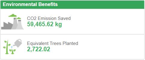
As an engineering company, we like numbers – very precise numbers in fact. While those numbers normally relate to water depth, range, frequency or days of vessel time saved using our equipment, etc., we’re currently getting to grips with some new numbers relating to our energy use and carbon footprint.
At the beginning of this year, we had 1,316 solar panels installed by Clean Earth Energy across the three buildings that make up our UK headquarter campus; Ocean House, Fathom House and Haven House. Each unit measures 201.5 cm × 99.6 cm, so in total they cover 2,641 m² (or just under 13 tennis courts). They’re the latest, most efficient panels and inverters on the market; JA Solar 405W high-efficiency PERC half-cell modules and SolarEdge inverters, respectively, which unlike earlier generation panels, allow us to individually monitor every panel for efficiency and performance.

A solar powerhouse – or rather three powerhouses
Together, our rooftop solar farm amounts to 533 kW that will generate in our part of southern England around 470,000 kWh per year. We estimate this will cover a minimum of a third of the energy consumption across our three buildings. That’s an annual 120 tonnes of CO2 equivalent emissions (CO2e) we have prevented from being emitted, not to mention the clean energy going back into the national grid when we’re not consuming it. It’s a great investment and one which has been several years in the making.
But while we’re hugely pleased to have these panels up and running, solar power generation is just the latest energy saving initiative we’ve committed to. In 2018, we invested in a Building Management System (BMS), which has learning algorithms to make the most efficient use of energy. It looks at how the building is heating and cooling to maximize efficiency, using things like destratification fans to move heat in a large space. We also changed all our light bulbs to LED panels and upgraded our heating systems to the most efficient types, including adding heat pumps. The result was that, between 2015-2019, energy consumption across our Blackbushe site was reduced by 23.5%. We’ve also reduced our travel overheads (even prior to Covid-related restrictions). What’s more, the electricity we are buying is all renewable, under a 100% renewable electricity supply we have, and now, thanks to the solar arrays, we’re putting more renewable power into the grid under Ofgem’s Renewable Energy Guarantees of Origin (REGO) scheme.
Calculating CO2e savings
Needless to say, for the past few years we’ve been formally calculating our carbon footprint, using the government approved PAS 2060 Specification, which has shown that, between 2018-2019, we reduced our emissions from 1,047 to 737 tonnes. With the solar panels coming online this year, we’ll see another dramatic drop in our 2019-2020 numbers.
All of these initiatives tie into our ISO 50001 Energy Management System Standard certification, which provides a framework of requirements relating to more efficient use of energy and continued improvement of energy management, so our efforts certainly do not and will not end here. We’re already looking at what more we can do. We’re also compliant with Energy Saving Opportunity Scheme (ESOS) Regulations and the Streamlined Energy and Carbon Reporting scheme.
Reduced waste as well as energy consumption
Of course, our impact on the environment doesn’t end there. We have also been focusing on reducing our waste streams across our sites globally, diverting more to recycling and doing more on a paperless basis. This has resulted in the removal of many tonnes of paper from our archives over the past 11 months, all of which has been recycled responsibly by a specialist. Our product design and manufacture through to recycling also follow European directives such as the Restriction of Hazardous Substances (RoHS) and Waste Electrical and Electronic Equipment (WEEE), using quality, sustainably sourced recyclable components.
There’s more to come, but if you’re interested in what we’ve done to date, feel free to get in touch.
Rheinmetall Canada Inc. has added underwater defence technology specialist Sonardyne’s Sentinel Intruder Detection Sonar (IDS) in its solution portfolio.
Rheinmetall Canada will integrate Sentinel IDS into its command and control system to enhance its overall security offering for harbour and port infrastructure protection. The company has already ordered its first Sentinel IDS for a customer as part of an integrated asset protection system.
Sentinel is the most widely deployed IDS in the market, providing reliable detection, tracking and classification of underwater intruders, from divers to unmanned vehicles, even in acoustically hostile harbour and port environments. It is easy to integrate and able to detect divers out to 900 metres and swimmer delivery vehicles to up to 1,500 metres in real-time. It can also be deployed in a wide range of configurations, from pillar mounted to surveillance or patrol vessel deployment and from seafloor based mounts to harbour wall deployment.
Sentinel IDS is also scalable. Individual and multiple Sentinel IDS sonar heads can be co-ordinated from a single command and control station, which can be seamlessly integrated into existing centralised security management systems.
Dan Zatezalo, Technical Sales Manager – US Maritime and Defense, at Sonardyne, says, “Intruder detection is changing. It’s not just divers that port and harbour infrastructure owners now have to worry about, it’s the increasing range of underwater unmanned vehicles (UUVs). Sentinel offers a proven, reliable, commercial, off-the-shelf (COTS) technology, widely deployed across ports, harbours, marine terminals, naval ships and floating oil production facilities across the world.”
[blockquote author=” Pietro Mazzei, vice-president, Rheinmetall Canada”]”As a leader in C2 and critical infrastructure protection we continue to enhance our solution by adding sub-surface detection and identification capabilities and are pleased to include Sonardyne’s Sentinel IDS system as part of our offering.”[/blockquote]
Integrated marine services company C-Innovation (C-I) has chosen a suite of Sonardyne’s underwater positioning and navigation systems to support its operations offshore Brazil.
Remotely operated vehicles (ROVs) on board six ROV support vessels (RSVs) in the country will be equipped with Sonardyne inertial, gyrocompass, and Doppler technologies, as well as hybrid acoustic-inertial systems.
Specifically, C-I has ordered SPRINT inertial navigation systems (INS), a Lodestar attitude and heading reference system (AHRS), Syrinx Doppler velocity logs (DVLs) and Sonardyne’s hybrid acoustic-inertial underwater vehicle navigation instruments, SPRINT-Nav. C-I has also ordered a quantity of Sonardyne’s Compatt 6+ transponders and Wideband Sub-Mini 6+ (WSM 6+) transponder/responders for tracking structures and vehicles.
Most of the vessels (including Bongo, Santos Service, Joe Griffin and Deborah Kay) will be working for Petrobras, and one vessel (Cabo Frio) will be working for Karoon Energy. The scope of work is subsea inspection, maintenance and repair operations (IMR) and ROV support.
Five of the six vessels, which start contracts in Brazil this year, are already equipped with Sonardyne’s Ranger 2 Ultra-Short BaseLine (USBL) positioning system, which is used for both dynamic positioning (DP) reference and deep water target tracking.
SPRINT-Nav combines Sonardyne’s SPRINT sensor, Syrinx 600 kHz DVL and a high accuracy intelligent pressure sensor packaged in a compact deep-rated housing that’s simple to integrate on both remote and autonomous underwater platforms. The tight integration of inertial sensor and raw acoustic aiding data at a low level enables SPRINT-Nav to regularly exceed the most stringent of positioning specifications, making it an ideal choice for vehicle guidance, station keeping and long endurance navigation.
[blockquote author=” Tomás Peixoto, Survey Manager at C-Innovation”]”We’re pleased to continue the relationship we have with Sonardyne, building on a long-standing partnership and with the local technical support that they offer here in Brazil. With these latest orders, we’re ensuring our fleet continues to provide unmatched services to our customers.”[/blockquote]
Speaking from Sonardyne’s base of operations in Rio das Ostras, Brazil, Sonardyne Sales & Applications Manager Andre Moura, says, “With the region’s majors committing to new and expanded field developments, the number, scope and value of engineering, procurement, installation and construction (EPIC) contracts placed here in recent months has risen significantly. The versatility and consistent high performance offered by our solutions means that C-Innovation can be confident they will see a return on their equipment investment throughout the life of the projects. That confidence, together with our in-country servicing and support, in turn helps to underpin their ongoing success in the market here.”
Authors: Luke Richardson, Sales and Marketing Manager at 2G Robotics, and Edd Moller, Global Business Manager Construction Survey at Sonardyne
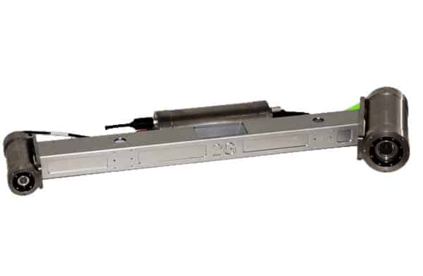
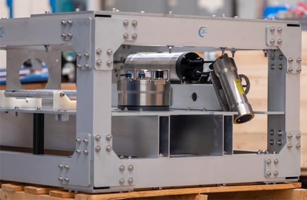
We’ve recently built a new deep-rated laser scanning skid specifically for generating extremely detailed volumetric point cloud models to complete repeatable survey work in the deep ocean.
It is a great product that is capable of delivering highly accurate and precise data of the seafloor and subsea assets, from pipelines to historic wrecks, all while packaging the capabilities of a dynamic laser scanning survey in one easy to use ROV skid.
The skid, a deep-rated 2G Robotics WROV Dynamic Laser Scanning Skid, builds on the breadth of experience between our Sonardyne Group companies 2G Robotics and Sonardyne to create a high precision system for underwater data collection.
Simpler, better offshore surveys
It’s a collaboration started back in 2015, when we saw the benefit of using our technologies together for dynamic laser scanning subsea structures with Apply Capnor. By amalgamating positioning data from Sonardyne’s SPRINT-Mapper which is a pre-configurated package of Sonardyne’s SPRINT INS and Syrinx DVL, and the point cloud data collected using 2G Robotics’ ULS-500 dynamic underwater laser scanner, we were able to generate fully georeferenced models that did not require manual point cloud stitching.
Integrating the SPRINT-Mapper into the 2G Robotics WROV Dynamic Laser Scanning Skid with the ULS 500 PRO meant much simpler offshore surveys because the equipment required to generate fully georeferenced models that did not require manual point cloud stitching are combined in one portable “plug and play” unit through the skid’s multiplexor.
System offsets are predefined, and a standard bolting pattern is included with the frame mounting plate allowing users to bolt the skid to their ROV and simply perform their survey; no need to take account of the offsets, no need to worry about complex system wiring, and no need to worry about accumulating the correct systems.
Using the fully integrated skid we created, we’ve proven its capability for performing dynamic laser scanning metrologies, with DOF Subsea, to name just one project.
Now we’ve developed the skid even further. Our newly developed deep-rated ROV skid takes advantage of the latest technological advancements at both 2G Robotics and Sonardyne, using the ULS-500 PRO system and replacing SPRINT-Mapper with Sonardyne’s latest SPRINT-Nav.
2G Robotics’ ULS-500 PRO
2G Robotics’ ULS-500 PRO, including both 4000 m and 6000 m depth rating options, was developed in 2017 and is a staple in the offshore industry for dynamic laser scanning projects. The system is used on surveys where the end customer requires extremely high-resolution and accuracy to make educated decisions on the condition of their subsea asset where other subsea sensors are not able to accommodate.
The laser offers substantially more detail to existing sonar solutions because it is optical-based, generating 2,048 points per laser profile, at a capture rate of 52 – 92 lines per second. Compared to photogrammetry, the laser can provide true details of the structure depth and damage, and generate models in shadowed areas, even when there are no defined features, because models are built using the geometry of the laser line on the target.
In addition, the laser model is generated in real-time, offering quality control capabilities while performing the survey live. These capabilities allow users to own their survey with real-time processed models that provide details unobtainable with other subsea solutions.
A deep-water challenge
However, we wanted to create a skid suitable for deepwater applications. To build accurate models in deep water, you need positioning. In shallow waters, you can use surface position updates, usually from an Ultra-Short BaseLine (USBL) system. But highly precise deep water scanning can’t rely on surface position updates. Here your options are using: a local Long BaseLine (LBL) array on the seabed; a sparse LBL array in combination with a good inertial navigation system (INS); or a very good INS.
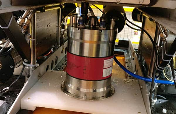
Furthermore, for some projects deploying Compatts on the seabed to form an LBL array isn’t possible, such as when a site is subject to the UNESCO 2001 Convention on the Protection of the Underwater Cultural Heritage – at these sites nothing can be put on the seafloor. That leaves only one option; using a very good INS.
High performance navigation with SPRINT-Nav
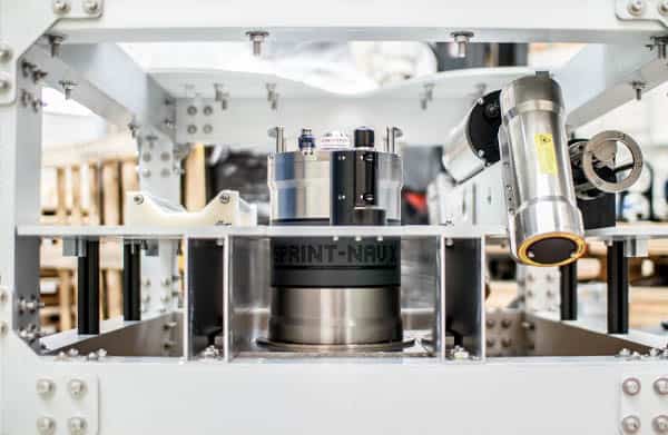
The standard WROV Dynamic Laser Scanning Skid normally comes with a SPRINT-Nav 500 – Sonardyne’s all-in-one, acoustic-inertial subsea navigation instrument for underwater vehicles. SPRINT-Nav’s tight coupling of a SPRINT INS, Syrinx DVL and pressure sensor, with individual beam-level aiding from the DVL, means optimal performance but also that the INS doesn’t suffer drift from DVL drop outs when its goes over obstacles on the seabed or a structure being mapped. Beam-level aiding means if one beam drops out, it doesn’t matter, bottom lock continues. That’s important when performing surveys over ground or objects prone to loss of bottom lock.
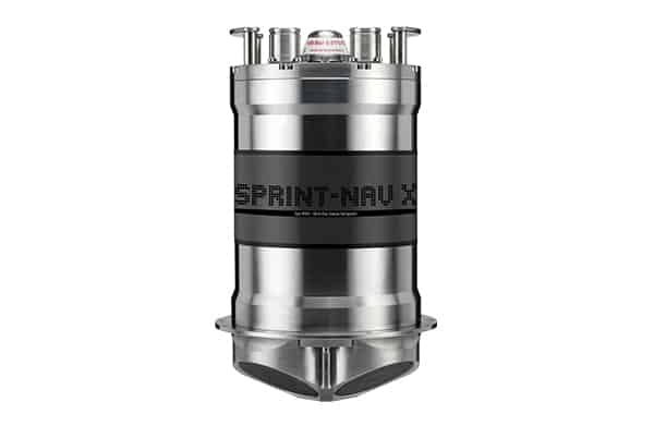
For this particular project, we went for a SPRINT-Nav X, the highest grade SPRINT-Nav currently available, in order to allow mapping without using a sparse LBL array and further reduce the INS drift. To give you an idea of its performance, SPRINT-Nav X achieves less than 1 nautical mile error for every 12 hours of unaided inertial navigation and better than 2 m error for every 10 km travelled with Doppler lock. While this options does require extra post processing of the laser scans, to join them together, the end result is the same and you’ve not had to deploy that LBL array.
Encompassing data collection, processing and visualisation
Data collection, processing and visualisation can be done by another Sonardyne Group company, EIVA a/s, using their NaviSuite software products, specifically using their NaviPac, NaviScan, NaviEdit and NaviModel products.
NaviPac provides real-time positioning and navigation for surface and/or subsea vehicles. Calculated NaviPac positions are sent to NaviScan, which is used when there is a requirement to record sensors that output high data rates, and that is the case when it comes to SPRINT-NAV and 2G Robotics’ ULS-500.
However, recording sensor data is a small part of any survey operation, whilst the ability to generate customer deliverables is always a necessity, which is why NaviEdit and NaviModel are so important.
NaviEdit allows users to analyse and edit sensor data in its raw form, whilst NaviModel allows us to visualize, interpret and quality control the results, thus allowing us to extract the maximum value from often divergent datasets to generate customer deliverables.
A new deep-rated laser scanning skid
The combined result is a single plug-and-play deep-water rated system able to provide its users with extremely detailed volumetric point cloud models with which they can complete repeatable survey work in the deep ocean, all without the hassle of offsets, wiring and corrections.
Whether that’s for seabed characterisation, subsea structure inspection, metrology, seabed scour monitoring, environmental modelling or coral mapping, it’s a neat solution and we can’t wait to see the results it provides.
This capability is possible by pulling together leading-edge technology from companies within Sonardyne Group, exemplifying the benefits of collaboration within our group.
So, if you want fully georeferenced models or metrology in deep water environments and without the need for manual point cloud stitching, the deep-rated 2G Robotics WROV Dynamic Laser Scanning Skid offers the solution for you.
It could be for pipeline span detection, general visual inspection, as-built modelling, crack detection or corrosion modelling. The WROV Dynamic Laser Scanning Skid is plug and play and ready to go whenever your mission needs it.
We can even offer the skid with our Remote Operations Access Module so if you do not have the experience, or feel the need of having full time support and on the job training, our survey group can dial in to your vessel offshore to access the system and help you, without incurring travel costs or onboard accommodation issues.
Marine technology company Sonardyne has announced that its Solstice multi-aperture sonar has been integrated into mine warfare command software used by the Royal Australian Navy (RAN).
Through a collaboration with Australian defence software engineering company Solutions from Silicon (SfS), data collected by Solstice during mine counter measure (MCM) missions can now be imported, processed and displayed in the most recent release of the MINTACs (Mine Warfare Tactical Command Software) which is in service with the RAN.
Sonardyne’s Solstice is widely considered a force multiplier for MCM operations, enabling substantially higher area coverage rates (ACR) using low-cost, low-logistics autonomous underwater vehicles (AUVs). It provides 200 m wide swath with an unrivalled 0.15° along-track resolution and consumes just 18 Watts, maximising vehicle endurance.
Solstice is now fitted, as standard, to General Dynamics Mission Systems’ Bluefin-9 and Bluefin-12 unmanned underwater vehicles (UUVs). Seven Bluefin-9 and Bluefin-12s will join the RAN’s UUV fleet this year under its SEA 1778 program. They will be based at HMAS Waterhen in Sydney and will search for, classify and identify sea mines.
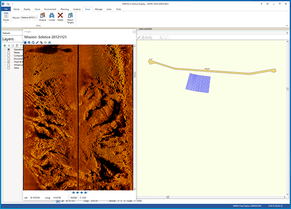
MINTACS provides the operator with the ability to not only read and display the Solstice data but also mark mine-like objects (MLOs) of interest and process the images with its powerful onboard automatic target recognition (ATR) capability. MINTACS is in service with host of countries around the world including the national navies of the UK, Australia, Malaysia, United Arab Emirates, New Zealand and Sweden.
[blockquote author=” Russell Norman, Technical Director, at SfS”]”Naval Mine Warfare is currently experiencing a major generational change that once complete will see unmanned and autonomous systems take on virtually all aspects of a traditional crewed mine hunter, including detection, classification, identification, and neutralization. With the significantly increased sonar ranges provided by Solstice, compared with traditional side-scan sonar, the goal of achieving the required area coverage rates is one step closer.”[/blockquote]
Ioseba Tena, Global Business Manager – Defence & Robotics, at Sonardyne, says, “At Sonardyne we are really proud to be supporting SfS and their efforts to provide additional capability to the Royal Australian Navy. We’re confident that, with Solstice data now within the MINTACS database, the Royal Australian Navy will see tangible gains as part of its ongoing expansion of its deployable mine countermeasures capability in the maritime domain.”
Just as a new generation of autonomous “Google cars” are being introduced onto our roads, unmanned surface vessels (USVs) are becoming an established tool for offshore operations, including in the defence space.
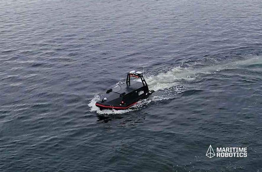
It’s not hard to see why. Using a USV vastly reduces the environmental footprint of many applications, enables people to work from home and saves cost over traditional operations.
However, these systems need to be reliable and they need situational awareness. There will be no sailor offshore to support their operation. If communications are severed, they will need to chart their own course and get to where they need to get to without incident. There will be no watchman to scan for obstacles.
Much has been achieved above the water. USVs can build a picture of the environment around them by fusing automatic identification system (AIS) data with charts and real-time observations of its surroundings using radar and lidar. How well the USV performs will largely depend on the quality of these sensors. But what about what’s under the water line, hidden from view? What if there’s an unexpected wreck, a rogue container or even an ice-berg that goes unspotted by the surface sensors?
Introducing Vigilant FLS
Vigilant FLS is our new long-range, forward-looking sonar for seaborne obstacle avoidance. It can be used to detect objects in the water column out to as far as 1,500 m (4,921 ft) away. In shallow waters and close to shore it can be used to generate a 3D terrain map of the seabed out to 600 m (1,968 ft) down to 100 m depth. It can be used to keep both a vessel and any system that it may be towing or deploying safe from hitting those obstacles with automatic obstacle and depth alarms that can be configured to suit.
What’s really exciting is that this technology is autonomous vessel ready. We have worked hard to ensure that all the outputs from Vigilant can be used by third party integrators and USV operators, straight out of the box.
Forewarned, forearmed
“When it comes to obstacle avoidance, what we need to do is offer time to react. We do that by extending the range of detection as far as possible. That was our focus,” John Chapman, Managing Director at Wavefront explains. Wavefront are part of Sonardyne Group and responsible for the design of the sonar.
“This is particularly important when working with unmanned systems as they must process the data to determine automatically what to do next. The data has to be served in as close to real-time as possible. We also wanted it to be installed in as many vessels as possible, either as a retro-fit or on brand new vessels. That influenced our design. The resulting range at 1,500 m and compact form factor are class leading.”
USV and unmanned ships, like autonomous cars, are no longer science-fiction. They are being developed and commercial outfits are extending the range of services that can be provided using these systems.
Like autonomous cars they have many hurdles to deal with legal, technical, commercial… Thanks to Vigilant FLS, underwater situational awareness is no longer one of them.
Want to find out how our Vigilant FLS could benefit your USV operations? Get in touch today.
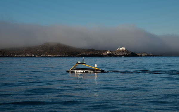
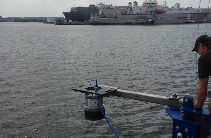
Underwater positioning equipment from Sonardyne Asia Pte Ltd. has been selected by PDE Offshore Corporation to support its work on wind farm construction projects offshore Taiwan.
The company has ordered a Mini-Ranger 2 Ultra-Short BaseLine (USBL) system and Wideband Sub-Mini 6+ (WSM 6+) transponder/responders to accurately track the position its underwater equipment, which includes a seabed frame used to guide geotechnical corers.
The Mini-Ranger 2 will be installed and operated from PDE Offshore’s 72-metre long survey vessel, MV Geo Energy, which is scheduled to spend this summer working in the Taiwan Strait, evaluating proposed locations for turbine foundations..
Mini-Ranger 2 is built around Sonardyne’s 6G hardware and Wideband 2 digital acoustic technology platforms. At its heart is HPT 3000, a highly capable surface-deployed USBL transceiver optimised for performance in shallow water, as well as high elevation and long lay back operating scenarios and data telemetry.
The size and positioning performance of WSM 6+ makes it a transponder choice for fitting to and tracking underwater vehicles and equipment. Its built-in depth sensor improves USBL precision, while a responder mode allows fast moving targets to the tracked at the highest possible update rate.
[blockquote author=” Huang Hsin-chih, president of PDE Offshore”]”Where we work in the Taiwan Strait, water depth is from 20 to 60 meters; in the future, there might be a chance to work in offshore wind farm with water depth from 50 to 200 meters, so whilst we do need a very precise USBL, we don’t need the one that’s full ocean depth capable. Through renting, we have become familiar with Mini-Ranger 2 and the benefits it’s brought to our busy geotechnical operations. So it was a simple choice to decide to go ahead and purchase one of our own.”[/blockquote]
Dan Tan, Regional Sales Manager for Sonardyne in Singapore, says, “Taiwan’s ambitions of becoming a green island means it is fast becoming a leading player offshore wind in Asia Pacific. We’re pleased to be a part this energy transition through PDE Offshore’s investment. Although this will be a permanent installation, Mini-Ranger 2 is also a great option for moving between vessels and even unmanned surface vessels (USVs).”
Protecting the underwater perimeter at critical assets can seem like a challenge. Whether you want to protect a port, harbour, refinery, private waterside residences or even a yacht, oil tanker or offshore platform, there are many variables. So, you need an underwater surveillance system with flexible installation options to ensure you are not left with any gaps in your maritime security.

Our Sentinel Intruder Detection Sonar (IDS) is the most widely deployed sonar of its type in the world, with more than 150 installations across a wide range of fixed and mobile assets. Sentinel detects, tracks and classifies divers and other underwater threats, such as swimmer delivery vehicles (SDVs) and autonomous underwater vehicles (AUVs), at ranges of up to 1,500 m* from any direction and alerts security personnel.
Flexible installation options for all scenarios
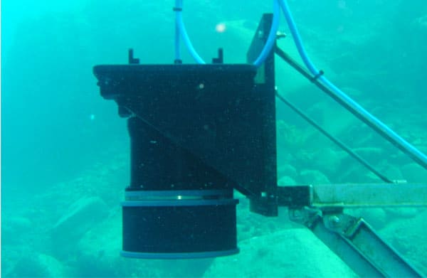
A Sentinel system comprises a topside, sonar head (or heads) and options to connect the two – usually cabled. We’ve developed many different ways the sonar head can be installed at waterside facilities or from vessels over the years. These include permanent systems on brackets, rail and trolley, columns, through-hull or through-tube deployment machines, over the side deployments and flanged systems – you name it. We’ve also got a portable system that’s easy to deploy, as and when you need it.
So what’s the best installation option for you? Broadly, your sonar head will need to be positioned so that it can focus on the first 20 m of water below the waterline – that’s where unwanted intruders, especially scuba divers or those using rebreathers, are more expected. But how you then position your sonar system really depends on your facility or vessel. Is it beachside or have you got harbour walls? How deep is your draft? Even the tidal range at your facility can influence system set up. Here, we take you through a few of the options.
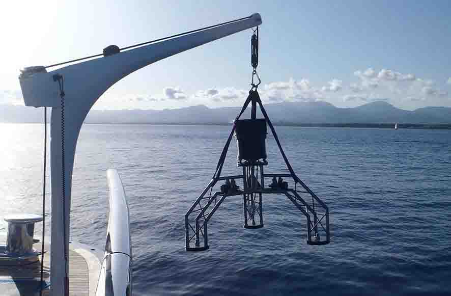
Portable asset protection
Our Sentinel Expeditionary System is an all-in-one portable system. It can be deployed using a small crane or winch from your yacht, vessel, pier or harbour. It comprises a sonar head mounted on a robust aluminium tripod, a topside system, which includes a display, and drum-deployed cable. It’s tried and trusted on, for example, private yachts, when mooring in unknown waters, as well as with security forces to check water ways of harbours, on specific occasions, such as before a high profile visit or event, or to be able to check different locations, when required.
Permanent underwater surveillance
For permanent surveillance, the options can be tailored to any facility – from private residences or quays/ harbours to waterside infrastructure such as a nuclear plant.
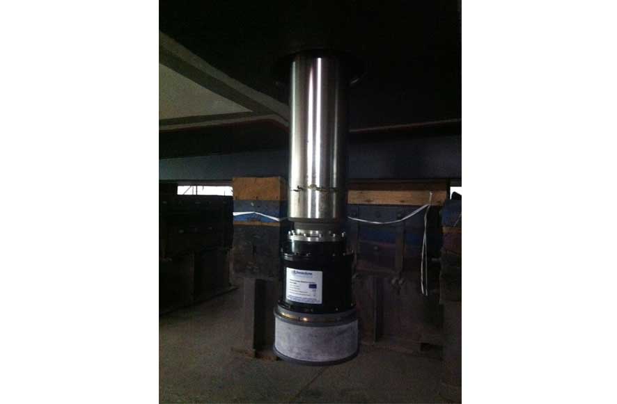
Perimeter protection of waterside facilities tends to require bracket, rail and trolley, or column mounted systems. A bracket system can be installed on a harbour or pier wall and provides 180 degree coverage. If you have a strong tidal regime, a rail and trolley system will enable the system to remain at an optimal depth throughout the tidal range as it changes. If you have a beachside or very shallow approach to you facility, a column mounted system (there are 1.5 m and 3 m column options) can be installed in the water further away from your facility, providing 360 degree coverage.
If you have a mix of shallow water and harbour wall or pier around your perimeter, or you have a large perimeter that you want complete protection of, you can deploy a number of sonar heads around the site, using the appropriate deployment system for each location. Each sonar head can then can be networked into a central command and control centre.
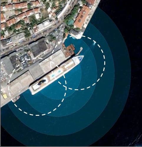
Offshore and vessel-based protection
For 360 protection at an offshore facility, that’s completely surrounded by water, two sonar heads providing overlapping 270 degree coverage each will cover your perimeter. Installation of the sonar heads can be done using flange mounts, brackets, over-the-side poles or through-tube poles, depending on your installation and what the best solution is for it.
In some scenarios, protection might also be provided to an offshore asset using a Sentinel aboard a support vessel. This could be using a through-hull, through-tube or over-the-side deployment. Here, a sprint and drift concept of operation is used – where the vessel “sprints” to an area of interest and then drifts, to minimize acoustic interference, so optimising surveillance of that particular area.
Cruise liners, oil tankers or other valuable vessels can also use through-tube, through-hull or over-the-side systems. And, as already outlined, smaller vessel owners can use Sentinel portable systems that are deployed by winch or crane when stationary. For deep draft vessels, some options are not ideal, where the deployment would be below 20 m water depth (beneath where common types of intruder approach). Here an over-the-side system might be preferable, tailored to where it’s best situated on your vessel.
 Some vessels also cable deploy their Sentinel sonar head over the side, when at anchor somewhere where they want to make sure they have no unwanted visitors.
So, as you can see, how you protect your site from intruders depends very much on the characteristics of your site or asset. Different deployment methods will suit one site or asset and not another. We can provide a tailored deployment to best suit your protection requirements.
Contact us to discuss your asset protection requirements.
*Depending on environmental conditions and product variant, 900 m range for diver detection.
Leading geo-data specialist Fugro has chosen underwater positioning technology from Sonardyne Inc. for its upcoming offshore wind farm projects in North America.
Fugro has ordered three Sonardyne Mini-Ranger 2 Ultra-Short BaseLine (USBL) underwater positioning systems to support shallow water site characterisation surveys, and a standard Ranger 2 for positioning geotechnical boreholes that will influence turbine foundation design and installation. In addition, Fugro has also ordered Wideband Sub-Mini 6+ (WSM 6+) and Nano transponders to fit to the underwater equipment it will be tracking with is new USBLs, including side-scan sonars and transverse gradiometer systems.
Mini-Ranger 2 is ideal for nearshore operations using small vessels, moored barges and unmanned surface vessels, and needing survey-grade positioning performance. It can simultaneously track 10 targets at very fast update rates, is quick to install and has an operating range of up to 4,000 metres. For this application, the Mini-Ranger 2 HPT 3000 transceivers will be mounted over-the-side of Fugro’s vessels to provide very shallow, high elevation tracking, without losing positioning accuracy.
Ranger 2 is Sonardyne’s highest performing USBL system, capable of simultaneous long range target tracking, dynamic positioning (DP) and subsea communications. It is being supplied to Fugro with an HPT 7000 Gyro USBL which combines the vessel heading, pitch and roll data that’s critical to USBL system precision, with an acoustic transceiver in a single housing.
Using Gyro USBL means that owners can move their Ranger 2 between vessels of opportunity and avoid the need to undertake post-installation performance tests before subsea operations can begin, saving expensive vessel time.
[blockquote author=” Char Franey, Sales Manager for Sonardyne in Houston”]”Ranger 2 is a great fit for Fugro’s busy work programme off the US East coast this summer. Investing in both Mini and standard Ranger gives them the flexibility to mobilise different size vessels for different tasks and have them working close to each other without causing interference. And because all versions of Ranger 2 use the same software, their crews will be able to easily switch between using the two systems.”[/blockquote]