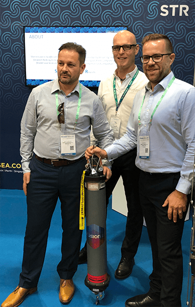
Subsea Technology and Rentals (STR), a multi-disciplinary technology expert specialising in the design, production, rental and sale of innovative marine survey equipment, has become the first company to invest in Sonardyne International Ltd.’s new Long BaseLine (LBL) and Inertial Navigation System (INS) software, Fusion 2. The announcement was made following Sonardyne’s launch event at OSEA 2018 in Singapore.
STR will upgrade its existing 6G hardware to Sonardyne’s new 6 ‘plus’ variants, which, combined with Fusion 2, will make marine survey and offshore construction projects faster and easier than ever.
Sonardyne’s new Compatt 6+ and ROVNav 6+ hardware has been designed to get the best performance from Fusion 2, a brand new software package that provides a single system from which surveyors can perform all of their LBL, acoustically-aided INS and Sparse LBL operations, with more functionality and capability than they’ve had before, including real-time SLAM calibration.
This performance is achieved with Wideband 3, which allows, for the first time, sensor telemetry data (e.g. pressure, depth, temperature) to be embedded within navigation (ranging) telemetry data, which means that there are no pauses in tracking when installing subsea structures, allowing operators to know exactly what’s happening at all times and reducing risk.
[blockquote author=” Simon Goldsworthy, Sales Manager, Sonardyne”]”The move to upgrade its 6G hardware to the new ‘plus’ variant will place STR in a prime position to be able to offer its clients the tools required to operate Fusion 2. This single solution means operators can undertake field development projects faster and easier than ever before.[/blockquote]
Speaking at the OSEA 2018 launch event, Scott Johnstone, Group Managing Director of STR said, “We are really impressed with the positive impacts that Sonardyne’s new Compatt 6+ and ROVNav 6+ hardware, combined with Fusion 2, will bring to the survey and construction industry. We know our customers are always looking to improve the efficiency and reliability of their operations and we believe that by upgrading our 6G stock to the newest technology this will definitely do that.”
A new platform bringing a step-change reduction in complexity and overheads for offshore operations has been launched by leading underwater positioning and navigation specialist Sonardyne International Ltd.
Available from today, Sonardyne’s Fusion 2 Long BaseLine (LBL) and Inertial Navigation System (INS) software has been written from the ground up to offer marine survey contractors and offshore construction companies a single solution from which they can undertake field development projects faster and easier than ever.
The integrated acoustic and inertial positioning platform builds on Sonardyne’s four decades’ experience as a trusted leader in precision LBL acoustics, its expertise in inertial and Doppler guidance, and its sensor integration capabilities to reduce system complexity, streamline workflows and increase productivity.
With Fusion 2, the separate software applications, vessel-fit hardware and often complex communication interfaces that have been typically required to support LBL, acoustically-aided INS and Sparse LBL operations, have been replaced with a single, unified solution that is easier and faster to set up and run.
Live in-water preview events held in the run-up to today’s launch in Singapore have provided audiences with the opportunity to experience first-hand how Fusion 2 will positively impact their offshore campaigns during the 2019 season and beyond.
One of the benefits demonstrated is the ability to undertake the real-time SLAM (simultaneous localisation and mapping) calibration of a sparse LBL transponder array while you survey – until now a lengthy offline post-processing activity.
Significantly reducing survey time is central to another key innovation that arrives with Fusion 2. Sonardyne has re-engineered the digital signal processing protocols used by Fusion 2 to command and control seabed arrays of its Compatt LBL transponders and vehicle-mounted ROVNav transceivers to Wideband 3.
Wideband 3 allows, for the first time, sensor data (e.g. pressure, depth and temperature) from a Compatt to be to be embedded with navigation (ranging) telemetry data. This will have a big impact on operations such as structure installation, accelerating update rates by a factor of 10 and eliminating issues operators currently face with latency.
To benefit from Wideband 3, Sonardyne has advanced its sixth-generation subsea hardware platform, with Compatt 6 and ROVNav 6 instruments now designated as ‘plus’ units, supplied as standard. To protect customers’ investments, these are backwardly compatible with existing inventories of Compatt 6s, which can also be upgraded to realise the potential of Fusion 2.
[blockquote author=” Edward Moller, Global Business Manager, Construction Survey, Sonardyne,”]”Today’s release of Fusion 2 marks the culmination of years of engineering development work that builds on the achievements of our original Fusion platform by creating, for the first time, a single system surveyors can use for LBL aided INS operations and with more functionality and capability than they’ve had before. We’re making set up easier and faster, including the ability to do system configuration before mobilisation. We’ve built in the ability to do real-time SLAM calibration and, with our Wideband 3 latest generation signal processing, 1Hz LBL update rates, which include sensor readings. Fusion 2 is also incredibly intuitive to use with a powerful customisable user interface and flexible operating environment, letting surveyors work how they want and see the information they want, when they want”[/blockquote]
Fusion 2 is being rolled out in two releases. The Fusion 2 INS pack, released today, delivers LBL aided operations using Sonardyne’s SPRINT INS technology. The second release, due in Q2 next year, will deliver the full acoustic LBL package. The Fusion 2 system works through Sonardyne’s Navigation Sensor Hub (NSH), which also supports the company’s Ranger 2 USBL system, so users will need fewer systems in their inventory and onboard their vessels.
Underwater positioning and communications technology leader Sonardyne International Ltd. has initiated a collaborative project to drive a major step change in ocean system autonomy for long-endurance autonomous underwater vehicles (AUVs).
The ambition of the Innovate UK-supported Precise Positioning for Persistent AUVs (P3AUV) project is to enable AUVs to operate at high levels of navigation performance with less surface support and for longer periods.
With partners L3 ASV and the National Oceanography Centre (NOC), Sonardyne will focus on longer-term navigational accuracy for AUVs in deep water, while reducing power requirements and increasing autonomy in marine operations.
The P3AUV project will involve trials using Sonardyne’s leading underwater positioning technology on the NOC’s Autosub Long Range (ALR) and L3 ASV’s C-Worker 7 autonomous surface vehicle (ASV). The project, which will include trials in Loch Ness next month, is due to run until late 2019.
The project will focus on three key areas. One will be increasing long-duration navigational accuracy by integrating low- and high-power Inertial Navigation System (INS) sensors.
[blockquote author=” Geraint West, Global Business Manager – Oceanographic, Sonardyne”]”The accuracy of low-power sensors degrades over time and AUVs consequently often have to surface to reinitialise with a GPS fix. However, by including high-performance, high-power navigation instruments, like our SPRINT INS, and integrating them with the low-power instruments to dramatically reduce power consumption, vehicle operators will get the best of both worlds, which will enable longer-duration independent deployments.”[/blockquote]
Second, we will improve positioning accuracy while underwater vehicles descend and ascend through the water column, through the integration of Doppler Velocity Log (DVL) current measurement capabilities and INS technologies with on board processing of data. “Our class-leading SPRINT-Nav instrument, which combines our SPRINT INS sensor, Syrinx DVL and a high-accuracy pressure sensor in a single housing, can measure water current as well as velocity relative to the seabed,” said West. “SPRINT-Nav will be able to use the water current velocity to reduce the dead reckoning mid-water navigation error, important to improving accuracy during both the dive and surfacing phases of an operation.”
The third area will be enabling ASV deployment of seafloor positioning transponders. “Autonomous low-cost deployment of seabed transponders by an ASV is attractive to the offshore energy industry for AUV operation, as well as a wide range of scenarios throughout the whole life of a field, including exploration,” added West. “Combining all of these capabilities will bring about a step change in AUV operations, providing a disruptive capability in the subsea monitoring and inspection space.”
“L3 ASV is excited by the promise of this technology, which provides autonomous systems with the capability to complete offshore work without the support of manned vessels,” said James Cowles, Commercial Technical Sales Manager, L3 ASV. “This project is a continuation of L3 ASV’s previous subsea positioning work, combining asset deployment and positioning.”
[blockquote author=” Aidan Thorn, Innovation Centre business manager”]”I am delighted that we continue to build on a successful partnership that was established around the Innovation UK Marine Autonomous Systems (MAS) round of funding in 2015, and continue to successfully bid for funding that enables novel deployment methods for MAS, which ultimately helps us to tackle the biggest scientific challenges. The strong and productive relationship between the NOC and our Innovation Centre partners is a proven example of UK industry and the public sector working together to generate mutually beneficial returns.”[/blockquote]
Underwater navigation and positioning company Sonardyne has reported new Ultra-Short BaseLine (USBL) equipment sales across Europe, Asia and the Americas.
Organisations operating out of the UK, Brazil, Thailand and Vietnam have acquired Sonardyne’s vessel-based Ranger 2 and Mini-Ranger 2 USBL underwater positioning technology for tracking a range of subsea assets, from small drones due to be deployed in Shell’s Ocean Discovery Xprize to divers and ROVs working on oil and gas facilities.
XPRIZE finalists TeamTao, which are supported by UK-based subsea equipment manufacturer SMD and Newcastle University, have acquired a Ranger 2 GyroUSBL system with AvTrak 6 OEM Nanos for tracking and communicating between a swarm of underwater drones and an unmanned surface vessel. The technology is due to be deployed in the final of the XPRIZE, offshore Greece, starting this month.
Thai offshore inspection, repair and maintenance company Beacon Offshore has acquired a Ranger 2 Survey package, with a Dynamic Positioning Transponder 6 (DPT 6) and transceiver deployment system for its latest vessel, the subsea support vessel SC Sirapat. The Ranger 2 system will be used on the vessel for ROV and diver tracking as part of inspection, repair and maintenance (IRM) operations on mobile and fixed offshore installations offshore Southeast Asia.
Brazilian underwater engineering company Belov Engenharia has acquired a Mini-Ranger 2 USBL system to track its ROVs during IRM work on floating production, storage and offloading vessels and their associated subsea riser and mooring systems offshore Brazil. The equipment will be installed and operated from the dive support vessel Cidade Ouro Preto, which operates across the region under a contract with Brazilian operator Petrobras.
Vietnamese offshore service company Greenstar Positioning has acquired two Mini-Ranger 2 USBL underwater positioning systems and a number of Wideband Sub-Mini 6 Plus (WSM 6+) beacons. The equipment will be used to track ROVs and divers on Greenstar’s upcoming projects, including the installation and survey of flowlines and pipeline protection mattresses and inspection, repair and maintenance work on oil and gas field infrastructure offshore Vietnam.
[blockquote author=” Graham Brown, Sonardyne Sales and Marketing Director”]”As these equipment orders and projects demonstrate, our USBL product family has grown and evolved to a point where we have models engineered for very shallow water or ultra-deep water, temporary or permanent vessel installation and tracking targets, from just a few metres away to over 11 kilometres – all built on a common technology platform. And it’s a family that continues to grow. Earlier this year, we introduced our smallest ever USBL system, Micro-Ranger 2, which has features that make it ideal for supporting diving and small vehicle operations in rivers, lakes and coastal waters. Between Micro, Mini and Ranger 2, with all the combinations of transponders and transceivers, together with our complimentary Doppler and inertial sensors, can meet any customers’ performance, budget and operational requirements.”[/blockquote]
Leading engineering consultancy BMT and subsea technology company Sonardyne International Ltd. have signed an agreement to provide advanced integrated marine integrity monitoring solutions to the oil and gas industry.
The official Teaming Agreement between BMT and Sonardyne, announced today [Thursday, 27 September] at the Rio Oil & Gas exhibition and conference in Brazil, will allow the two companies to collaboratively provide smarter and more efficient through-life solutions for monitoring and managing critical subsea assets, including drilling and production risers, moorings and wellheads.
By jointly offering BMT’s monitoring and analysis capabilities with Sonardyne’s expertise in autonomous, long-endurance data collection and through-water telemetry, clients globally will benefit from a wider range of options to bring more subsea integrity data to their desktops faster, making it easier for them to make safety critical decisions at the right time.
BMT and Sonardyne already have a strong working relationship and see this agreement as an opportunity to offer a further step-change in the solutions provided to customers. BMT will bring 30 years of marine instrumentation design experience and extensive integration expertise to the working arrangement, while Sonardyne will provide access to subsea data logging and communication technology including its SMART low-power subsea sensors.
Stephen Auld, Global Business Manager, Subsea Asset Monitoring, Sonardyne, says, “BMT are market leaders in marine instrumentation and riser monitoring technology and, having worked with them for a number of years now, we see this agreement as a way to transform what we can offer to the industry by working more closely together.”
[blockquote author=” Rob Barker, Regional General Manager at BMT”]”Sonardyne are a world leader in the development of through water positioning and communication technology and these are integral components for our subsea integrity monitoring systems. We are delighted to have formalised a collaborative agreement with them.”[/blockquote]
The two companies are already working on proposals for major operators globally, which would offer significant cost reductions on existing systems, with longer periods between maintenance.
Sonardyne and BMT will be present at Rio Oil & Gas in Brazil this week (September 24-27). Sonardyne is exhibiting in Hall 4, stand Q44.
Underwater target tracking technology from Houston-based Sonardyne Inc., has been chosen by the US Naval Surface Warfare Center (NSWC), Carderock Division for use at its South Florida Ocean Measurement Facility (SFOMF).
Located in Maryland, Carderock Division is the US Navy’s research, engineering, modelling, and test centre for surface and undersea technologies. It is the largest, most comprehensive establishment of its kind in the world. Thanks to its proximity to the Gulf Stream, Carderock’s SFOMF provides a demanding open ocean test environment for subsea systems and unmanned underwater vehicles (UUVs) in development for both the Navy and wider maritime industry.
To support this work, Carderock Division has ordered Sonardyne’s high accuracy Ranger 2 Ultra Short Baseline (USBL) acoustic tracking system, complete with a GyroUSBL transceiver, Nano and Wideband Sub-Mini 6 Plus (WSM 6+) transponders.
Mobilized aboard vessels-of-opportunity, the Ranger 2 system will enable operators to track the precise underwater position of any subsea system or UUV that comes through the SFOMF for testing. The system offers the capability of tracking systems in both shallow and deep water, near the surface and over very long ranges. By purchasing both Nano and WSM 6+ transponders, all sizes of vehicle can be accommodated, from man-portable models through to extra-large (XLUUV) designs.
Dan Zatezalo, Technical Sales Manager at Sonardyne Inc., said, “This system will more than meet Navy expectations. Our Ranger 2 GyroUSBL is a survey grade acoustic positioning system with built-in attitude and heading sensors, which makes moving it from vessel to vessel easy, with no new calibration required. Used alongside Nano, our smallest ever, rechargeable acoustic transponder, and WSM 6+ transponders, which both support our secure Wideband 2 signal protocols, the NSWC has a high-performance and time-saving system for its operations at Maryland. This sale also further embeds our commercial-off-the-shelf capabilities, field-proven within the US offshore energy and science sectors, into the North American defence market.”
The SFOMF has housed an active, continuously operating Navy range for more than 50 years. Its main mission is to perform electromagnetic signature tests of Navy assets, using multiple fixed, in-water electromagnetic and acoustic measurement sites. The facility also tests and evaluates mine detection, countermeasures and mine response; performs acoustic measurements; and acquires radar cross section and infrared signatures.
Author: Ioseba Tena – Global Business Manager – Marine Robotic Systems
Autonomous underwater vehicles (AUVs), subsea robotics and remote operated vehicles (ROVs) will come under the spotlight in Aberdeen tomorrow for Subsea UK’s Underwater Vehicles Conference (UVC). This is an industry that has experienced a painful downturn, one which has also encouraged innovators to seek out new solutions to optimise their performance.
 There is a new generation of ROVs and hybrid- field resident AUVs and they will have many different challenges: inspection, intervention and mapping, with less support infrastructure, over wider areas and/or at higher speeds.
At the core of all these missions is a requirement for vehicles to be able to navigate reliably in all conditions and to a given accuracy level. To date, navigation has been the sum of its parts: a Doppler velocity log (DVL) tells the vehicle its speed and altitude from the seafloor; a depth sensor its depth; the gyro its heading; the USBL/LBL (Ultrashort BaseLine/Long BaseLine) a latitude and longitude coordinate. An Inertial Navigation System (INS) may also be used to improve short-term accuracy, precision and reliability. The vehicle must then integrate all these inputs for vehicle guidance and navigation.
However, most of these instruments are designed only for standalone operation and so improvements in accuracy and reliability that can be gained with tight integration are not realised. In addition, all these separate instruments must be calibrated or aligned to each other; a task that can be complex and error-prone in the offshore environment. Timing between the instruments is another challenge.
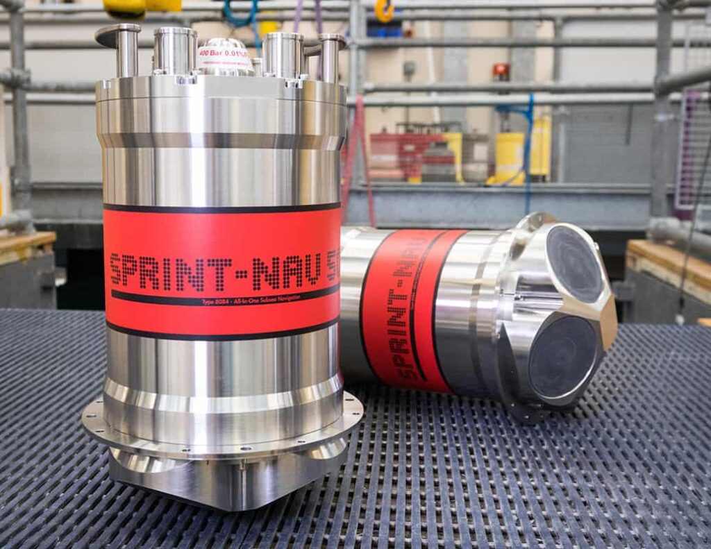 We have developed a hybrid navigator, SPRINT-Nav, which tightly integrates all the raw sensor data at a low level to provide unprecedented improvement in self-contained or ‘dead-reckoning’ navigation accuracy and reliability.
It enables significant efficiencies and cost savings for both current underwater vehicles and the emerging new generation resident vehicles. Many missions, such as pre-lay survey and inspection, can now be performed without any assistance from surface vessels or subsea infrastructure, achieving accuracies two to five (and more) times better than separately integrated instruments at the same cost. Hybrid navigation also supports a step-change in seabed relative station keeping, typically achieving <1 metre error over 24 hours. Importantly, for resident vehicles, this level of performance can be achieved within 10 minutes of start-up, even in a static seabed dock – no special alignment trajectories need to be flown, saving previous precious operational time and on-board battery power.
Where extremely high accuracy is required, SPRINT-Nav can be combined with seabed acoustics to provide centimetric levels of accuracy, enabling the most demanding dynamic mapping and imaging missions such as subsea metrology.
Our Engineering Manager Malik Chibah will be explaining mission specific performance and how we achieve it in more depth at 1.50pm during UVC, which is being held at Aberdeen Exhibition and Conference Centre. We’ll also be suggesting how this technology can be applied to across other industries such as renewables, aquaculture and defence.
Come talk to us at the conference and we’ll discuss the right fit hybrid navigation for your vehicle and missions or contact us here.
Underwater engineering and technology company Sonardyne International Ltd. has announced the appointment of Stephen Auld as its new Global Business Manager for Subsea Asset Monitoring.
Stephen, who joined Sonardyne last June (2017), takes over the role from Stephen Fasham, who has been promoted to a newly created role within the business focussing on growth and investment opportunities.
Asset monitoring is increasingly critical to oil and gas companies’ ongoing safe and profitable operation of offshore infrastructure, which, in a growing number of cases, is operating for longer than it was originally designed for.
Sonardyne’s portfolio of acoustic positioning, sonar imaging, data logging and wireless communications technologies is already well established in the offshore energy sector across a range of applications, including leak detection, riser monitoring, reservoir surveillance and pipeline creep.
[blockquote author=” Stephen Auld, Global Business Manager for Subsea Asset Monitoring, Sonardyne”]”Subsea asset monitoring is a growing market and one where we can offer customers more. Our technology is being used for a whole range of projects in this area that are diverse both geographically (from Brazil to Australia via West Africa) and in terms of how our technology is used. Our Sentry product is a great example. It’s a sonar that is able to detect and classify oil or gas seeps down to 0.1 barrels per day at ranges of up to 500 metres. We can take the first in class results that we’ve had with these technologies further, helping clients to operate safely and cost-effectively.”[/blockquote]
Before joining Sonardyne last year, Stephen was Business Development Manager at Liquid Robotics Oil and Gas, which was a joint venture between oilfield services company Schlumberger and Liquid Robotics Inc. Before joining Liquid Robotics, Stephen was Managing Director at CodaOctopus Products Ltd.
Sixth generation (6G) underwater positioning technology from Sonardyne Brasil Ltda. has been chosen by vessel owner and operator Companhia Brasileira de Offshore (CBO) to meet Brazil’s stringent new contracting specifications for subsea positioning.
The multi-functional Compatt 6 transponders and Ranger 2 USBL (Ultra-Short BaseLine) HPT transceivers that make up the order will be utilised alongside existing Sonardyne technology onboard the ROV support vessel CBO Isabella in support of a wide variety of subsea operations, including structure installation, pipeline metrology and ROV tracking.
On long-term contract to Petrobras since 2010, the CBO Isabella opted to have available two independent acoustic positioning systems so that operations can continue in the event of a single system failure. For the past few years, this requirement has been met through a combination of Sonardyne’s Fusion LBL, Optimised Ranger 2 USBL and SPRINT INS technologies; providing the vessel with the flexibility to meet virtually any project requirement in any water depth, including Sparse LBL, full LBL and acoustically aided inertial navigation for the vessel’s work-class ROV.
Replacing the CBO Isabella’s previous generation through-hull transceivers with fully digital HPT transceivers completes her upgrade to 6G, and means the vessel can exploit the full benefits of Sonardyne’s 6G technology. This is proven to offer stable and precise positioning for DP, reliable structure and vehicle tracking in any water depth and support for simultaneous vessel operations using shared seabed transponder arrays already deployed in the field.
The work equip the vessel’s inventory of Compatt 6 LBL transponders with high specification DigiQuartz pressure sensors was carried out at Sonardyne’s service, support and training centre in Macaé, Brazil.
The ability for multiple unmanned subsea-surface systems to work together on joint survey missions, controlled from shore, has taken a step closer to operational reality following a two-week trial in Scotland’s Loch Ness.
During trials in and on the loch, Sonardyne International Ltd.’s USBL acoustic positioning and AvTrak telemetry systems enabled an unmanned surface vessel (USV) to locate, track and command and control an unmanned underwater vehicle (UUV). Position and mission status updates were transmitted to shore via surface communications.
The mission also included, for the first time, through-water transfer of data collected by a Sonardyne Solstice multi-aperture sonar on the UUV to the USV, using Sonardyne’s BlueComm optical modem.
The demonstrations, involving the NOC’s Autosub Long Range (ALR) and ASV Global’s C-Worker 5, were the culmination of the three-year Autonomous Surface and Sub-surface Survey System (ASSSS) collaborative project. The project was led by ASV Global with partners Sonardyne, the National Oceanography Centre (NOC) and SeeByte Ltd., supported with funding from Innovate UK and the Defence Science and Technology Laboratory.
The need to collect more data from the marine environment means that marine autonomous systems need to be at sea for longer. Pairing a UUV or autonomous underwater vehicle with a USV means that positioning accuracy – crucial for high-quality survey data – can be optimised on missions lasting weeks, if not months, without the need for manned surface vessel support. By using optical and acoustic communications systems, the survey data can also be accessed more economically and missions can be updated on the fly, according to what is found, without the UUV having to surface or needing to be recovered.
The aim of the ASSSS project was to deliver an integrated system to perform low cost, full water column marine surveys using multiple unmanned systems.
Proving acoustic enabled multi-vehicle tracking, command and control with optical data transfer through the water column also lays the ground work for long-range, over-the-horizon autonomous underwater vehicle survey operations, says Geraint West, Global Business Manager, Oceanographic.
“This is the first time we have put all of these market-ready technologies on the same vehicle,” he says. “We’ve shown that our technology can enable a UUV to operate autonomously with a USV and offload its Solstice side-scan survey data using BlueComm.”
Furthermore, because Sonardyne’s USBL and AvTrak technologies are able to track and communicate with multiple subsea platforms, a single USV is able to manage swarm operations, further extending unmanned operational capabilities.
[blockquote author=” Matthew Kingsland, Senior Robotics Systems Engineer, NOC”]”We are now able to send down new missions via acoustic communications to avoid the ALR having to surface from 6 kilometres deep. We are not only tracking, we are getting quality data back from the system via acoustics, so we can make informed decisions.”[/blockquote]
Ruth Taylor, Product Manager – (Science), ASV Global, said: “The whole system potential is massive. The aim was to make the two vehicles work together autonomously. With BlueComm connected and being able to back-up the data autonomously and send it to shore much sooner is pushing the boundaries and taking autonomous operations to a new level.”