Sonardyne
Support Centre

A new way to monitor previously hidden, but disruptive, deep ocean currents in near-real-time has been proven, thanks to a recently completed uncrewed technology collaboration in the US Gulf of Mexico. 

In a science-industry first, marine technology companies Sonardyne and SeaTrac Systems used advanced sensors and uncrewed surface vehicles (USVs) to deliver science-ready deep ocean current data on the Gulf’s Loop Current System, direct to scientists’ desks in near real-time.

The project, commissioned and in collaboration with the University of Rhode Island (URI), opens the door to reliable, on-demand and sustained high-resolution observations of powerful and dynamic ocean systems, without the need to send people offshore.

In turn, this boosts scientists’ ability to improve predictive models, helping industry and science understand and mitigate the hazards posed by disruptive deep ocean currents, like the Loop Current System.

The project was completed during Fall 2025 and funded by the U.S. National Academies of Sciences, Engineering and Medicine’s Gulf Research Program.

“Sustained deep-ocean measurements remain rare despite their importance,” says Randy Watts, Professor of Oceanography, URI. “This project demonstrates how commercially available instruments and uncrewed vehicles can deliver science-ready data in strong current systems – overcoming the dual challenges of station-keeping where most USVs fail and cost-effective deployment without expensive research vessels.”

“With SeaTrac, we’ve proven that long-term, persistent monitoring of powerful and dynamic ocean systems with USVs instead of traditional vessels is now a reality,” says Michelle Barnett, Business Development Manager for Ocean Science at Sonardyne. “Remote-commanded systems can reliably deliver the high-quality oceanographic data researchers and industry need, when they need it with lower operational costs than traditional vessels.”

“This mission has demonstrated a new global precedent for using USVs to make critical, sustained ocean data accessible, consistently – with zero crew risk, zero emissions and a repeatable approach we can scale to other regions,” adds Hobie Boeschenstein, Director of Operations and Business Development at SeaTrac.

The collaboration used Sonardyne’s advanced Origin 65 seabed acoustic Doppler current profilers (ADCPs) and SeaTrac’s SP-48 USV to gather near-real-time current profile data from the Loop Current System.

Over 18 months, four Origin 65s and five pressure inverted echosounders were deployed in 1,800 to 3,200 m water depth, in the heart of the LCS, 200 nm off the coast of Louisiana.

Origin 65 is a 4,100 m-rated, low frequency, deepwater profiling ADCP. It can profile up to 800 m range in time-aligned, high resolution and also comes with pressure inverted echo sounder (PIES) functionality.

Thanks to Origin 65’s integrated Edge processing capability and acoustic modem, data could be acoustically harvested from the surface by SeaTrac’s remotely piloted USV, using a Sonardyne HPT 7000 transceiver.

The solar and battery powered SP-48 was tasked with navigating variable ocean currents and weather conditions in the Gulf to reach the sensor locations and harvest the data. It was then able to send the science-ready data to shore through its dual iridium and Starlink satellite links, which also enabled high-data rate and real-time communications back to shore.

In total, three deployments covering more than 30 days, the SP-48, which can sustain 2 to 3 kt operations and sprints up to 5 kt, covered around 1,500 nm. During this time, more than 135 GB of high-resolution ocean currents and related parameter data at up to 800 m above the bottom were harvested.

0

days

0

nm

0

GB data

Going forward, data gathered during the mission will improve models that forecast currents such as topographic Rossby waves, providing critical insights for science and safety in the region and opening new avenues for future research.

The project demonstrates a scalable model for autonomous ocean observation around the world.

This includes showing how marine autonomy can deliver near real-time data to enhance the prediction of – and safety against – disruptive deep currents such as topographic Rossby waves, which can threaten offshore infrastructure, while also improving scientific understanding of ocean circulation and climate processes.

“Completion of this project marks another successful demonstration of USVs in offshore data collection and marine science,” Boeschenstein said.

“Deploying advanced technologies like those from SeaTrac and Sonardyne is key to deepening our understanding of the world’s oceans. There is still so much to explore, and our teams are proud to help scientists safely reach and study some of the most challenging marine environments on Earth.”

Watch – Origin 65 – our long range ADCP

France-headquartered STAPEM Group has chosen Sonardyne’s Ranger 2 Ultra-Short BaseLine (USBL) technology as the permanent solution for one of its flagship offshore support vessels, the STAPEM Boreale.

Operating in one of STAPEM Group’s key regions, Angola, the vessel is now equipped with a Ranger 2 Gyro USBL 7000 system, an all-in-one, high-performance USBL system for precise positioning performance, previously used on a hire basis.

Ranger 2 Gyro USBL 7000 is optimised for ultra-deepwater operations and, like all Ranger 2 Gyro USBL systems, includes a single, pre-calibrated transceiver head. Its integrated attitude and heading reference system (AHRS) / inertial navigation system (INS), eliminates mechanical alignment errors, making it easy to deploy and increases tracking precision.

Onboard the 2024-delivered STAPEM Boreale, it will support remotely operated vehicle (ROV) operations, including inspection, survey and intervention work, by Film-Ocean – a STAPEM Group company.

This often requires long layback tracking, touchdown monitoring and precision navigation close to subsea assets—scenarios where the accuracy and reliability of the Ranger 2 Gyro USBL system bring real value.

The investment reflects STAPEM Group’s wider strategy of continuously upgrading its subsea technology portfolio. This includes already having equipped the 59.5 m-long vessel with an SMD Atom work class ROV, fitted with Sonardyne combined solid state AHRS and Syrinx Doppler velocity log (DVL) and a Wideband Sub Mini 6+ (WSM 6+) transponder.

Film-Ocean Operations Director Mike Mackie and Alan MacDonald, Head of Sales, UK, Europe and Africa, at Sonardyne.

Film-Ocean Operations Director Mike Mackie and Alan MacDonald, Head of Sales, UK, Europe and Africa, at Sonardyne.

“STAPEM Group’s investment reinforces the STAPEM Boreale as a versatile platform, ensuring permanent access to high-precision subsea positioning, improved reliability and strengthened operational autonomy. We’re delighted to be supporting them as they continuously invest in their subsea technology capability and efficiency,” says Alan MacDonald, Head of Sales, UK, Europe and Africa, at Sonardyne.

“The STAPEM Boreale embodies our vision to continuously invest in the future of subsea operations,” says Jean-Marc Gerber, CEO of STAPEM Group. “By combining advanced positioning solutions like the Ranger 2 GyroUSBL system, with our new Atom work-class ROV, we strengthen our capacity to deliver safe, efficient and cost-effective subsea services for our clients in West Africa.”

Mike Mackie, Operations Director at Film-Ocean, adds, “The Ranger 2 delivers the accuracy and reliability required for our subsea operations. Its integration on the STAPEM Boreale enhances our ability to provide precise positioning during inspection, intervention and survey campaigns, even in the most challenging offshore conditions.”

It has been a few weeks since I joined Sonardyne and it has been a fantastic experience so far. I was lucky enough to join the week of the company’s annual Houston BBQ, so I couldn't pass up the opportunity to head south and meet all the great colleagues in Houston, right from the get-go.

As Business Development Manager, North America, I’ll be primarily focused on marine robotics, initially in the US Northeast and down the eastern seaboard.

The rise of BlueTech 

BlueTech, as we might call it, is on a meteoric rise and the market for marine robotics and autonomous solutions is experiencing strong, sustained growth.   

This is mostly driven by technological advances, lower barriers of entry, strong federal funding and government initiatives, like NOAA’s Ocean exploration Cooperative Institute and Navy programmes, as well as private investment.   

That’s matched by increasing demand across multiple sectors, whether that’s offshore energy, coastal resilience and environmental monitoring or defence. 

These drivers mean marine robotics and autonomy are no longer confined to small laboratories or within the secret walls of defence contractors. They’ve broken out and are proving themselves more than sci-fi fantasy. The future is now and the hype is all real!   

How does Sonardyne facilitate the transition from concept to reality? We help build the infrastructure needed to get prototypes in the water by building test ranges and helping tech mature from concept to commercialization at a faster pace.   

We work alongside leading oceanographic institutes like Woods Hole Oceanographic Institution and Scripps Institute of Oceanography to expand their horizons.  We collaborate with growing oceanic and maritime institutes to ensure we are pushing boundaries and keeping the next generation of graduates inspired, motivated and in complete awe of what we can accomplish together. 

The New England robotics hot spot 

The New England East Coast area, in particular, has always been a strong market for robotics with top tier schools like Massachusetts Institute of Technology (MIT), Harvard UniversityBrown University, University of Rhode Island and the University of Massachusetts constantly pushing the boundaries of what robotics can accomplish.   

These robotics powerhouses are bringing their tech to the sea, spending more time working with marine sciences, technology accelerators and securing funding opportunities to make dreams of the past tangible solutions right now.   

One example of this type of ongoing collaboration is the Ocean Tech Hub, a federally designated tech hub based in Southeastern New England and led by the Rhode Island Commerce Corporation. The Hub leverages the academic community as well as its unique coastal assets (seven commercial ports and shallow and deep ocean access) to meet growing commercial demand for digital and physical testing and manufacturing environments for rapid prototype testing. In doing so, the Ocean Tech Hub seeks to advance ocean technology innovation and become a global leader in the growing ocean economy.

Mesobot-team-members-Lui-Kawasumi-and-Eric-Hayden-deploy-the-vehicle-off-the-Nautilus.-Photo-by-Marley-Parker_Ocean-Exploratoin-Trust.jpg

Advancing robotics – advancing autonomy 

While remotely operated vehicles (ROVs) still dominate the underwater robotics market, the tide is turning – the future belongs to autonomy. 

Increased battery life, continuously improving autonomous navigation systems and advances in AI are only pushing the growth in the autonomous underwater vehicles (AUV) market.  

Monitoring of our oceans, whether for oil and gas, offshore wind, ocean science and research or defence and security, can be done with long duration data collection – with minimal human intervention. All while making the process more efficient, reliable and capable of complex tasks.   

It’s an exciting space to be in. We’re moving toward a truly connected ocean — a digital ecosystem where autonomous platforms, sensors and subsea networks operate collaboratively, continuously gathering and transmitting data to inform decisions above and below the surface. 

My journey and experience 

So how did I find myself here?  

I grew up in the oil and gas industry, moving around every few years during my childhood, as my father was a petroleum engineer with BP.  I have lived in Alaska, Aberdeen, Louisiana and Texas, and spent my teenage years down in Bogota, Colombia.  I moved back to Texas to finish high school, then wrapped up my bachelor’s degree in international business at Baylor University shortly thereafter.   

After a year out, teaching English in Bangkok, Thailand, exploring Asia and then spending several months helping the tsunami recovery efforts in 2004-5, I moved back to Texas to complete my MBA. 

I applied my MBA to the retail industry, then moved over to the oil and gas market in 2012, spending seven years with Heerema Marine Contractors before joining Seaway7 in 2019. This initiated my move to Rhode Island a year later, joining the “gold rush” of offshore wind in the US.   

It was a great experience, forging a new presence in the Northeast and trying to get a brand new industry off the ground which brought plenty of complex challenges both commercially and politically. 

Driving and delivering change and innovation 

All in all, I’ve spent most of the past 13-plus years focused on business development within the marine construction sector, building new infrastructure, from pipelines and floating production units to offshore wind foundations and inner-array cable installations.   

What drives me isn’t just finding new clients and opportunities but collaborating early in the design and field development stages to apply cutting-edge technology, innovative engineering and creative delivery models. 

I’ve worked across business units to develop and execute strategies for some of the most complex and forward-thinking projects. That drive — to deliver new solutions and push the boundaries of what’s possible — is what ultimately brought me to Sonardyne.  

Here in the US, I’m eager to use my experience in business development and strategic partnerships to uncover opportunities and solve problems the market doesn’t yet see. 

It’s not all robotics…  

Of course, life isn’t all about work. What also drives me (sometimes nuts) is my three boys (13, 11 and 9 years old) that I can talk about all day, so I’ll keep it brief for now. The three of them keep my wife and I extremely busy with sports and school events throughout the year.   

When we have free time, we are at the beach, in the mountains or exploring all the opportunities the great outdoors has to offer around New England. We also have a very active three-year-old boxer who keeps us busy when we try and find an opportunity to relax at home. You’ll probably see her jumping on the window during a Teams call, she doesn’t like to be left out of anything! 

If I haven’t spoken to you yet, please feel free to reach out at any time. I am working remotely and always eager to jump on a call, with or without our boxer! 

Images, from the top: 


  • Top, a view at Sail Newport in Rhode Island from Dan Zatezalo
  • Dive Technologies’ (now Anduril) AUV during testing. See post.
  • Mesobot team members Lui Kawasumi and Eric Hayden deploy the vehicle off the Nautilus. Photo by Marley Parker_Ocean Exploration Trust. See post.
  • Nautilus and DriX. See post.
  • Zach and family, with the Thialf in the background. Zach and family kayaking. Sabine the boxer.

Underwater technology company Sonardyne is to provide passive seismic monitoring services at the UK’s first carbon capture and storage (CCS) site.

The services, added to an existing contract with Northern Endurance Partnership (NEP) will form part of a wider monitoring programme at the Endurance CO2 storage site beneath the North Sea.  

Sonardyne will adapt, deploy and operate advanced ocean bottom seismometers (OBSs), manufactured by Germany technology company KUM GmbH, on the seabed above the Endurance storage reservoir, about 75 km off the coast of Yorkshire.   

NEP will enable carbon captured by emitters in Teesside and the Humber – collectively known as the East Coast Cluster – to be transported and then stored in Endurance, and neighbouring storage sites.

Storing up to 100 million tonnes of CO2

The initial phase of the project is expected to see up to 100 million tonnes of CO2 stored in the Endurance aquifer over a 25-year period, helping to achieve net zero goals in one of the UK’s most carbon intensive industrial regions.   

The additional work scope at Endurance is a further endorsement of Sonardyne’s capabilities in support of CCS operations, building on its existing contract to provide environmental monitoring services using Sonardyne technologies across the Endurance site.  

NEP is building CO₂ transport and storage infrastructure for the East Coast Cluster. Image courtesy of NEP.

“NEP is continuing to lead the UK’s journey to net zero through its development of carbon capture and storage at the Endurance site. Our collaboration with Sonardyne plays a critical role in ensuring carbon is stored safely and securely,” says Michael McGhie, Technical Manager at NEP. 

The passive seismic monitoring services to be provided will generate baseline data ahead of NEP operations, with a potential for these services to continue into injection, to provide longer-term surveillance of the subsurface.

The UK’s first operational CCS project

Storage at the site is expected to start in 2028, making it the first operational CCS project in the UK.   

“Being trusted to deliver passive seismic monitoring, in addition to environmental monitoring, for the UK’s first CCS project is an honour and highlights Sonardyne’s technical leadership in subsea environmental monitoring,” says Stephen Auld, Business Development Manager for Custom Projects at Sonardyne.   

“We are committed to supporting NEP’s work to deliver safe, long-term containment of CO₂ offshore and are very proud to contribute our expertise to this landmark project.” 

The OBS monitoring scope is expected to start in the summer of 2026 with the first seismic data delivered to NEP one year later. This will help to characterise any naturally occurring seismic activity in this region. 

Passive seismic monitoring

Sonardyne will adapt, deploy and operate advanced ocean bottom seismometers (OBSs), manufactured by Germany technology company KUM GmbH.

They will be deployed on the seabed above the Endurance storage reservoir, about 75 km off the coast of Yorkshire.

Learn more: Carbon capture and storage: a critical component of climate change mitigation

Watch: Carbon capture and storage – The critical role of monitoring subsea

Across the marine robotics sector, operators face ongoing challenges in achieving precise underwater localisation and robust coordination for autonomous vehicles. Addressing these obstacles is critical for advancing multi-vehicle operations, whether it’s for environmental monitoring, streamlined surveys or a military mission.

We recently sponsored a team of engineering students at ETH Zürich who are developing underwater swarm capability for 3D environmental sampling in Swiss Lakes. They used our Micro-Ranger 2 with Robotics Pack to develop and demonstrate their robotics.

The challenge

Monitoring environmental pollution in dynamic waters can be challenging, especially using traditional sampling methods from a vessel. This typically involves point sampling, resulting in a limited number of data points, each gathered at a different point in time, hindering spatial and temporal coverage.

The Swiss Federal Institute of Technology’s (ETH Zürich) SWARM team set out to develop a better solution, using underwater robotics. Specifically, they wanted to show how a swarm of drones could gather data simultaneously, across multiple locations, and also move towards where pollutant levels are increasing (gradient tracking) to find the source.

Students gathered around robotics equipment in a workshop
Mini AUVs on a wooden jetty with a Sonardyne Micro Ranger 2 system.
Students gathered around robotics equipment in a workshop
Mini AUVs on a wooden jetty with a Sonardyne Micro Ranger 2 system.

Working in partnership with the ARIS student association and the Swiss aquatic research institute Eawag, their goal was an autonomous underwater vehicle (AUV) swarm capability. This would include synchronised sampling in up to 30 m water depth to create high-resolution 3D pollutant maps with spatial precision below 10 m.

The mission is environmental sampling to support research around the proliferation of antibiotic-resistant bacteria and their effects on the environment in Lake Geneva. Achieving this mission meant finding a solution for real-time, reliable positioning and robust inter-vehicle communication.

The solution

We supported their project providing use of a our Micro-Ranger 2 Ultra-Short BaseLine (USBL) positioning system with Robotics Pack.

Micro-Ranger 2 is designed for shallow water tracking of divers and small remotely operated vehicles (ROVs) and AUVs out to 995 m range. It’s a one-box solution with everything you need, delivering positioning accuracy of less than 5 m and supporting tracking of up to 10 vehicles or targets simultaneously, with updates up to twice per second.

“We first deployed our Micro-Ranger 2 topside and transceiver poolside, enabling testing of our AUVs in a safe environment. After validating proper operations, we then took the plunge and deployed our AUVs in Lake Zurich, with Micro-Ranger 2 topside and transceiver deployed from a pontoon,” says Henrik Eberhardt from team SWARM.

Three AUVs were deployed, each fitted with AvTrak 6 Nano transceivers, our smallest multifunction acoustic transceiver, providing navigation aiding, simultaneous USBL tracking, telemetry and robust communications.

A concern was that noise in the lake, caused by their own vessel motors motors, would interfere with the acoustics.

“The AvTrak 6 Nano’s built-in Fast Fourier Transform tools meant vessel noise was not a problem. We were reliably securing robust, low-latency bi-directional communication update rates between the AUVs and Micro-Ranger 2 by choosing the right frequency address for communication.”

Raniah Madi Team SWARM
Close up of the mini AUV and its control systems inside.

The approach demonstrated the potential to dramatically increase spatial and temporal environmental data resolution, as well as faster, safer and more repeatable data acquisition.

“Sonardyne’s Micro-Ranger 2 and AvTrak 6 Nano provided the accurate underwater localisation essential for our robots’ autonomous navigation and coordinated swarm behaviour,” says SWARM Team Lead and Project Manager Alexander Sheridan. “Their technology enabled real-time position updates, transforming underwater autonomy from concept to reality.”

Next steps – the Polaris project

SWARM left impacts at ETH Zürich and ARIS that go beyond the project conclusion. Following the success of the original team, a successor project was launched and tasked with exploring safety and climate research by venturing beneath the ice of lake St. Moritz, a touristic and economic hub in the Swiss Alps.

A new autonomous vehicle is currently being developed specifically for this mission, combining both previous experiences and novel innovations in order to competently achieve its mission.

The mission is to measure the ice layer thickness in a vast and accurate grid – without compromising personnel safety in any way.

Find out more at the project website.

Watch: Micro-Ranger 2 USBL for ROVs

Underwater positioning and tracking technology from Sonardyne has been chosen for three new oceanographic research vessels being built under the US’ National Science Foundation (NSF) Regional Class Research Vessel (RCRV) construction programme.

Led by Oregon State University, the state-of-the-art RCRVs are being built for the US’ Academic Research Fleet (ARF), enabling a new era of coastal and regional marine science.

To support the RCRV’s scientific missions, across diverse marine environments, Oregon State University selected Sonardyne’s Ranger 2 Gyro USBL 7000, engineered to meet both the demanding, multidisciplinary research objectives of the ARF and vessel-build requirements.

The first system has recently been delivered to Oregon State University to be fitted to the R/V Taani, to be operated by the university, by vessel builder Bollinger Houma Shipyards.

Systems for the other two vessels, R/V Narragansett Dawn (to be operated by a University of Rhode Island-led consortium) and the R/V Gilbert R. Mason (to be operated by the Gulf-Caribbean Oceanographic Consortium) will be delivered next year.

“The RCRV construction programme represents a significant enhancement to the US Academic Research Fleet,” says James Caison, Design Specialist, at OSU working on the RCRV programme. “These vessels will empower researchers to address critical questions in climate, ecology, and ocean dynamics across the Pacific coast, east coast and Gulf of Mexico.”

“The RCRV construction programme represents a significant enhancement to the US Academic Research Fleet,” says Kim Swords, Technical Sales Manager at Sonardyne. “This order is an endorsement of the precision and reliability delivered by our Ranger 2 USBL systems. It reinforces Sonardyne’s position as a trusted provider of high-performance acoustic positioning technologies for the US marine science and research community.”

Advancing precise tracking for coastal and regional research

Sonardyne’s Ranger 2 will allow US researchers to accurately track and simultaneously communicate with multiple underwater scientific instruments, vehicles or towed platforms, at ranges up to 10,000 m depending on its configuration.

The Ranger 2 Gyro USBL 7000 system was specifically selected for its precise acoustic tracking performance, integrated gyrocompass and proven reliability in complex deployment scenarios.

With Ranger 2 Gyro USBL, scientists and researchers using the RCRVs can be sure of optimal underwater positioning and tracking capabilities, without the need for separate external heading sensors.

For vessels equipped with a dynamic positioning system, Ranger 2 can also provide accurate and repeatable position referencing, in any water, without interrupting target tracking operations.

Learn more about the RCRV programme here.

Ranger 2

Our Ranger 2 family of USBL products represent the most capable USBL tracking and communication technology available on the market.

Consisting of software, a top-side transceiver and in-water transponders, Ranger 2 brings together all the features you need, and more.

For more than five decades, Sonardyne’s work in pioneering underwater technology has been guided by a focus on sustainable growth and the formation of enduring international partnerships.

These principles have shaped our approach through every chapter of our story. Our vision has always centred on enabling safe, secure and environmentally sound operations across the world’s oceans. This vision is not static—it drives us to continually question, adapt and improve how we engineer, operate and plan for the long term.

Achieving carbon neutrality

Reaching carbon neutrality for our UK operations in 2023, two years earlier than our original goal, stands out as a significant point of progress. Achieving this milestone was not just a matter of ambition, but the result of careful measurement, reduction and offsetting of our emissions and a shared sense of responsibility at every level of the organisation.

It demonstrates how environmental responsibility and high standards in operational performance can, and must, be interwoven.

Earlier this year, we earned our second consecutive carbon-neutral verification, with our 2024 footprint confirmed to ISO 14064 standards and our management system meeting ISO 14068. We also expanded our scope to include our Brazil, Singapore, and Houston offices and were happy to take delivery of two new Ford Transit E-Custom electric vans, further decarbonising our vehicle fleet.

Our commitment extends beyond our own footprint. Through technological solutions supporting offshore renewable energy and advancing environmental monitoring, we have aimed to equip others to operate with greater awareness of their impact.

By focusing on reducing vessel time, optimising fuel use and improving operational efficiency, we contribute in practical ways to a healthier marine environment.

Recognition through the King’s Awards

These efforts were recognised this year through the King’s Award for Enterprise for Sustainable Development. In early October, we celebrated this achievement at our head offices in Yateley, Hampshire, with a visit from His Majesty’s Lord-Lieutenant of Hampshire, Nigel Atkinson Esq.

It was a double celebration, marking our achievement in also winning a King’s Award for Enterprise for International Trade.

Indeed, recent years have also seen Sonardyne deepen our international engagement. Sustained growth in direct exports—an 83% increase over the past three years—is a reflection of our long-term relationships and a shared goal of progress with partners in more than 100 countries.

Expanding into new markets, such as Germany, where, earlier this year, we opened a new office, has opened further opportunities to collaborate and learn.

These experiences reinforce the value of genuine partnership and knowledge exchange in advancing both business and environmental objectives.

Indeed, our double King’s Awards are recognition of a collective and connected endeavour. These are linked priorities that are fundamental to how we evolve as a company and as part of the wider marine community.

It’s also heartening to note that it’s also just over three decades since our first Queen’s Award in 1994. This was an award for Technological Innovation, for the development of our SIPS – Seismic Integrated Positioning System (SIPS) – technology.

Since then we received a further three Queen’s Awards: for Export Achievement in 1999; for Enterprise in Innovation in 2014, for our underwater digital acoustic communications technology; and in 2021, for our seabed deformation monitoring technology.

Future challenges and goals

Looking forward, the path is not without its challenges. Responsible growth requires a balance between innovation and stewardship. Our continued investment in research and development, and in building robust relationships across sectors, will be essential.

The marine environment is constantly changing, and so too must be our approach—always seeking a better way, always mindful of our responsibility.

While there is satisfaction in what has been achieved, there remains more to do. Our progress should serve as a foundation for further reflection and action, ensuring that advances in technology and trade continue to support a more resilient and sustainable future for the world’s oceans and those who rely on them.

As climate change accelerates and organisations face mounting pressure to cut emissions, the need for sustainable innovation has never been greater. From ocean research and monitoring to offshore operations, we're leading the charge with groundbreaking technologies that enable zero-carbon data harvesting. By harnessing uncrewed vehicles and advanced ocean sensors, we're transforming how we explore and protect our oceans—safely, efficiently, and sustainably.

A sea change in ocean monitoring 

Traditional methods of collecting oceanic data have long relied on large, fossil-fuelled survey and research vessels. While these can provide reliable harvests, they come with significant drawbacks: high operational costs, considerable carbon footprints and potential risks to personnel navigating often challenging sea conditions. 

Scientific research vessels, in particular, are also often in high demand, but with limited berths, and can’t be everywhere all the time, resulting in tough decisions around what science can and can’t be done. Through a series of groundbreaking deployments across multiple ocean environments, we are providing a way to ease the burden across science and industry.  

Using uncrewed surface vessels (USVs) and advanced ocean and environmental sensors, it’s a lower cost, lower carbon option, helping scientists and operators to gather the data they need to answer the toughest ocean and operational questions.

“It has never been more important to have accurate and up-to-date measurements about what is happening in our ocean, which is undergoing major and rapid changes in the face of climate change. This project gave the first example of through-water communications of ocean climate research data to an autonomous vehicle and instant transmission of data to shore.”

Professor Mark Inall – physical oceanographer at the Scottish Association for Marine Science (SAMS)

Transformative technology for environmental monitoring and climate research 

At the heart of our oceanic data collection is our acoustic communication technology. As well as being able to track and communicate with underwater vehicles, our HPTs (High Precision Transceivers) enable robust through-water communications between USVs and seabed sensors.  

Mounted on to the USV hull, HPTs can communicate with sensors at depths down to 4,000 m, while deployments have successfully retrieved data from sensors as deep as 3,200 m deep.  

Our seabed sensors provide the instrumentation needed to answer critical questions about our planet, from shifting tectonic plates and globally – climatically – significant ocean currents to safe offshore operations. 

From our Fetch AZA Bottom Pressure Recorders (BPRs), capable of detecting sea-surface height changes of just one centimetre, to our Fetch pressure monitoring transponders (PMTs) that track small seabed movements, these devices are collecting the crucial data scientists need, remotely, safely and reliably.

Three success stories, one vision

Ormen Lange: supporting net-zero ambitions

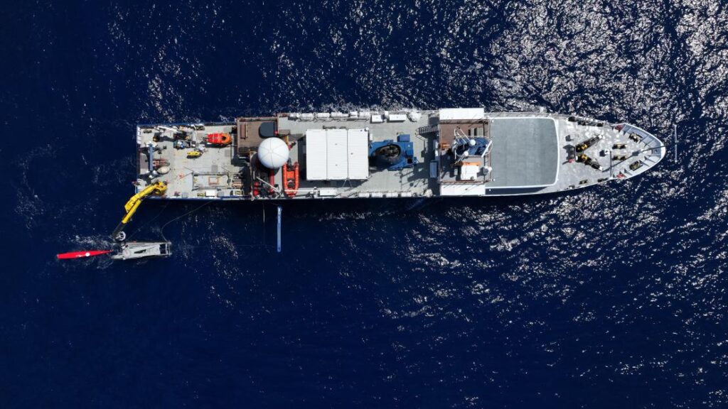
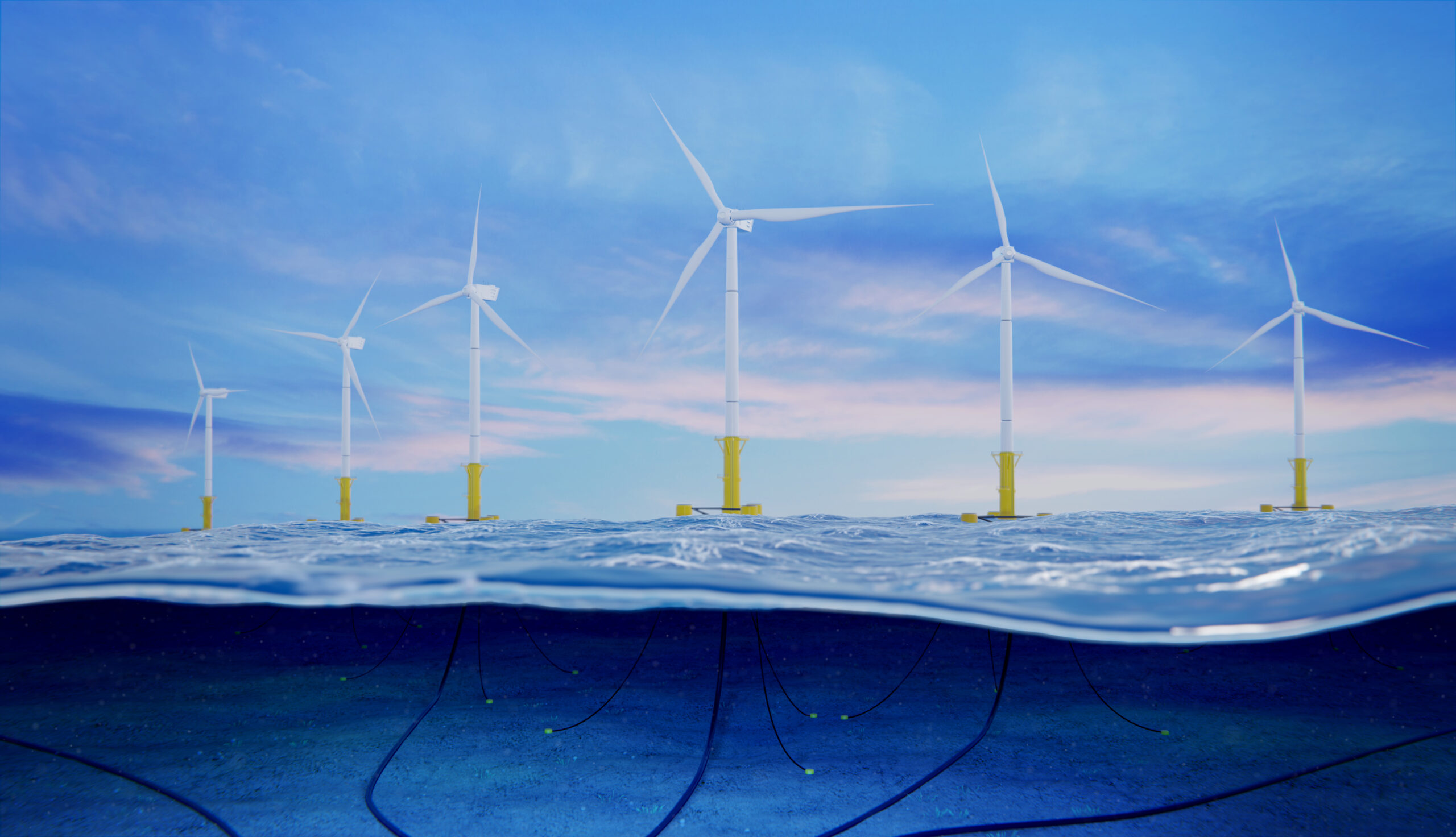
In Norway’s second-largest gas field, 120 km off the Norwegian coast, Shell faced a challenge: how to monitor the seabed around their Ormen Lange field without the carbon footprint and personnel risks associated with traditional vessel operations.

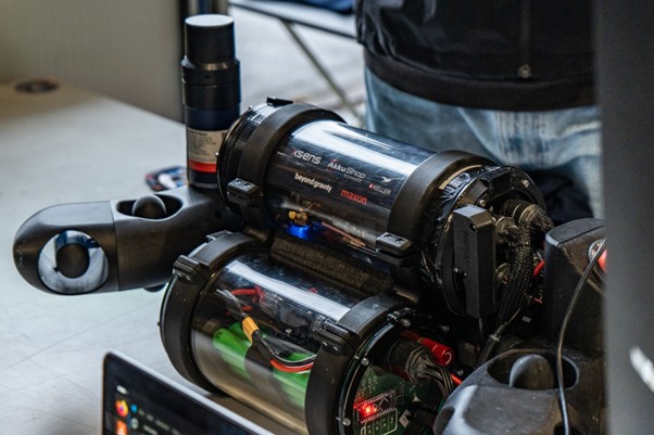
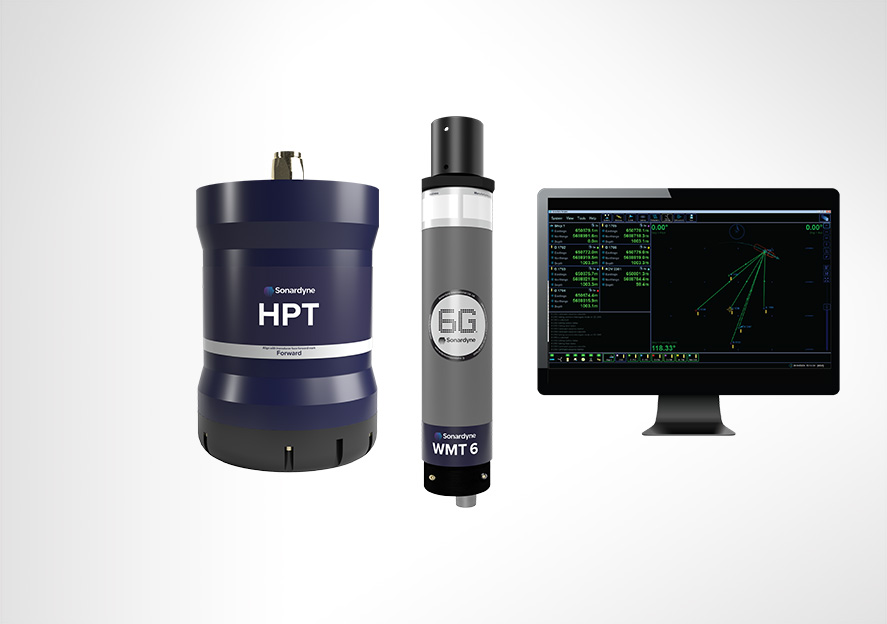
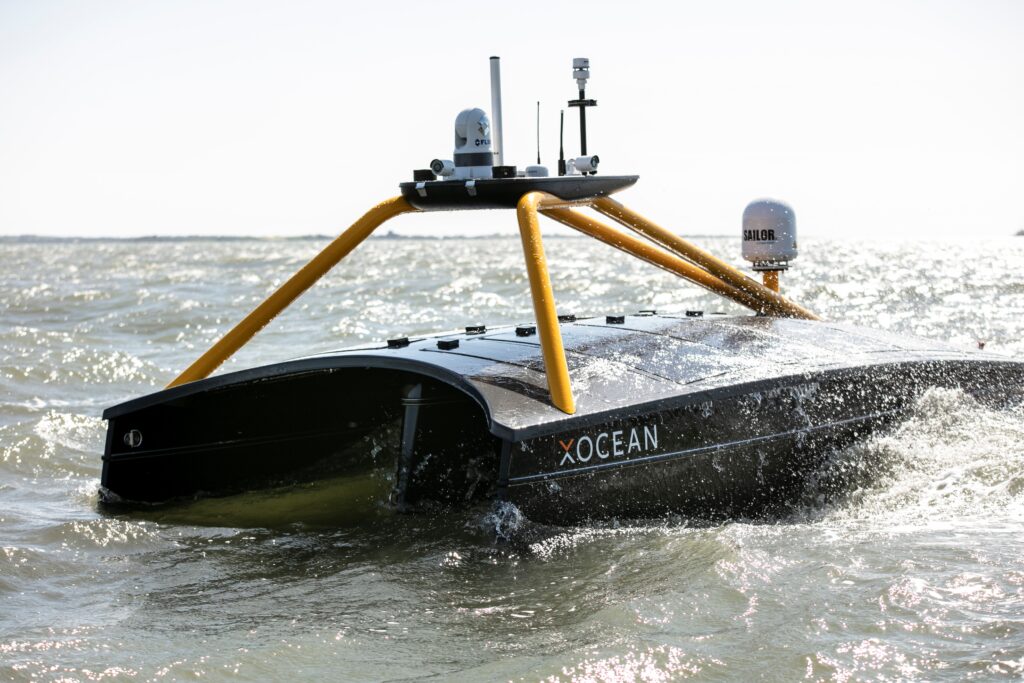
The solution came through partnership between us and XOCEAN. Using XOCEAN’s USVs, equipped with our HPT 3000, the team established a remote data harvesting operation to collect data from 75 of our Fetch pressure monitoring transponders (PMTs) on the seabed.

“In Shell we are always looking for new, innovative ways of working that can reduce risk to both people, assets and the environment,” says Egil Syre, Project Manager at Norske Shell. “Uncrewed surface vessels fitted with transceivers have proven highly suitable for harvesting PMT data. Carbon emissions are reduced to almost zero and we don’t need to send people offshore anymore.”

This ongoing project, which began in 2020, marked the first time a remote USV data harvest was completed in Norwegian waters by any operator.

Rockall Trough: a first for oceanography

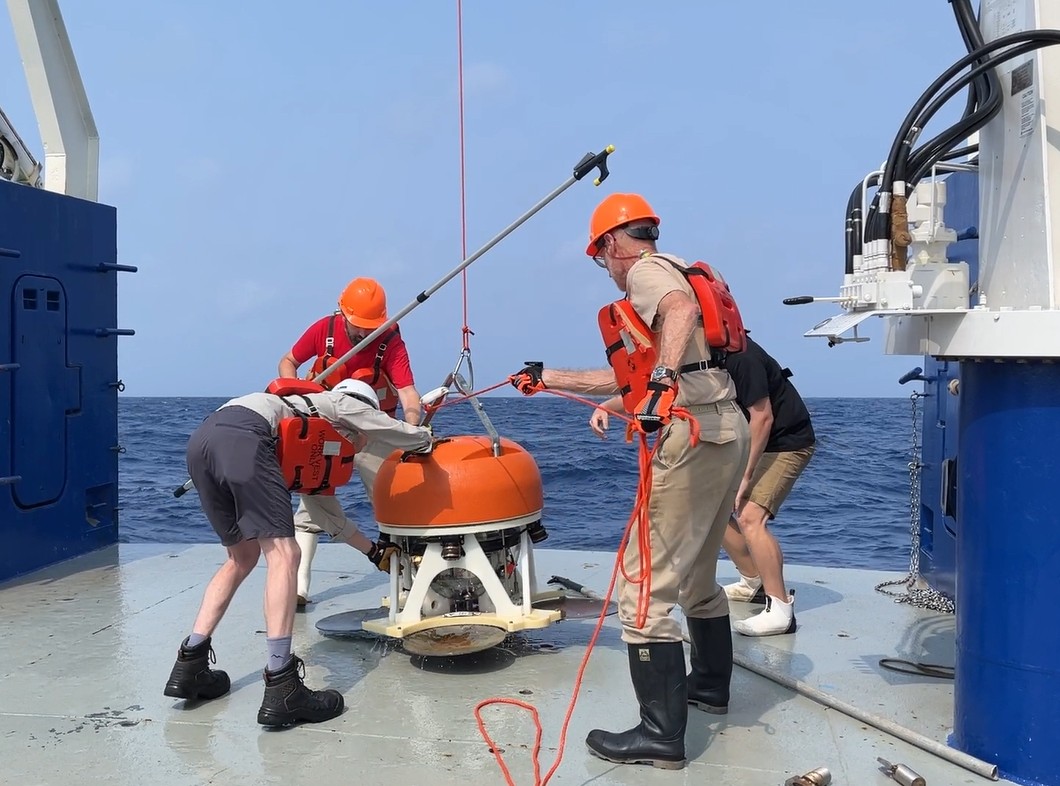
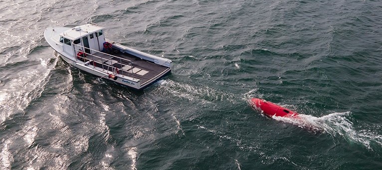
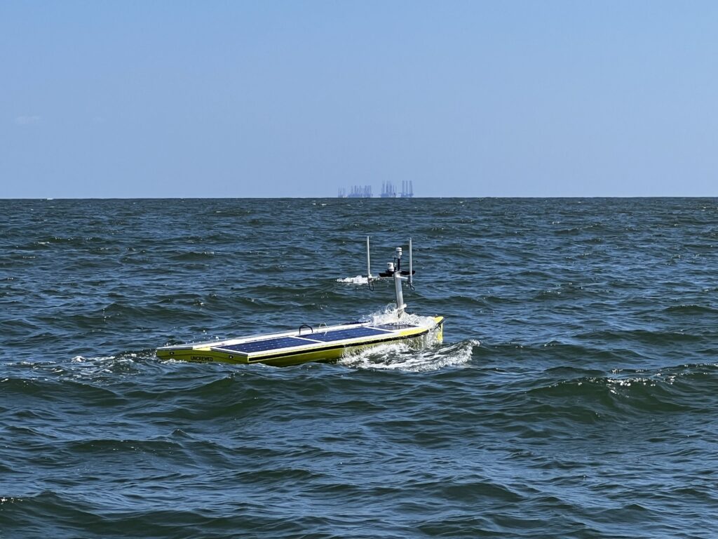
In a pioneering mission that oceanographers called “a major milestone for oceanography”, a 5 m-long AutoNaut USV was deployed to retrieve data from Fetch AZA bottom pressure recorders (BPRs) moored 1,800 m deep in the Rockall Trough, northwest of the UK’s Shetland Islands.

The sensors are part of a 10-year research project by the Scottish Association of Marine Science (SAMS) to measure pressure and currents on each side of the Atlantic Ocean and study their effect on our climate.

Equipped with our HPT 3000, the wave-propelled USV successfully collected data from Fetch AZA BPRs on the seabed, retrieving climate critical data and transmitting it to shore via satellite – reducing cost, emissions and HSE risk.

AutoNaut founding Director Mike Poole said: “This was the first time in the 10 years of AutoNaut’s experience we had been asked if can we get zero carbon data. It is a practical and positive response to climate change and, importantly, will probably become much cheaper than sending manned, diesel-fuelled ships.

“We look forward to further zero carbon harvests with the aid of Sonardyne technology as this long-term project progresses.”

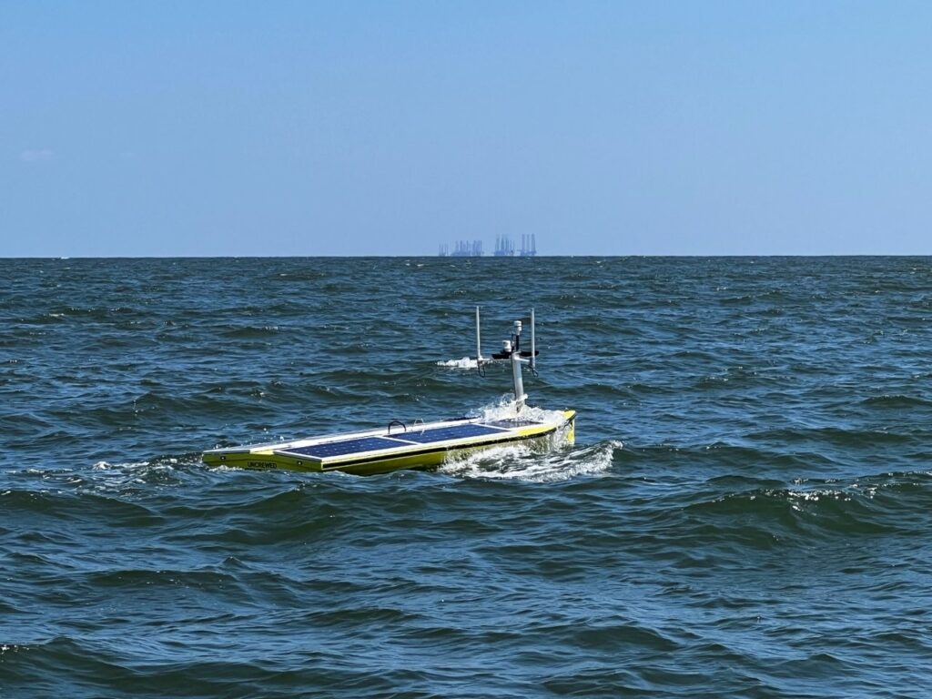
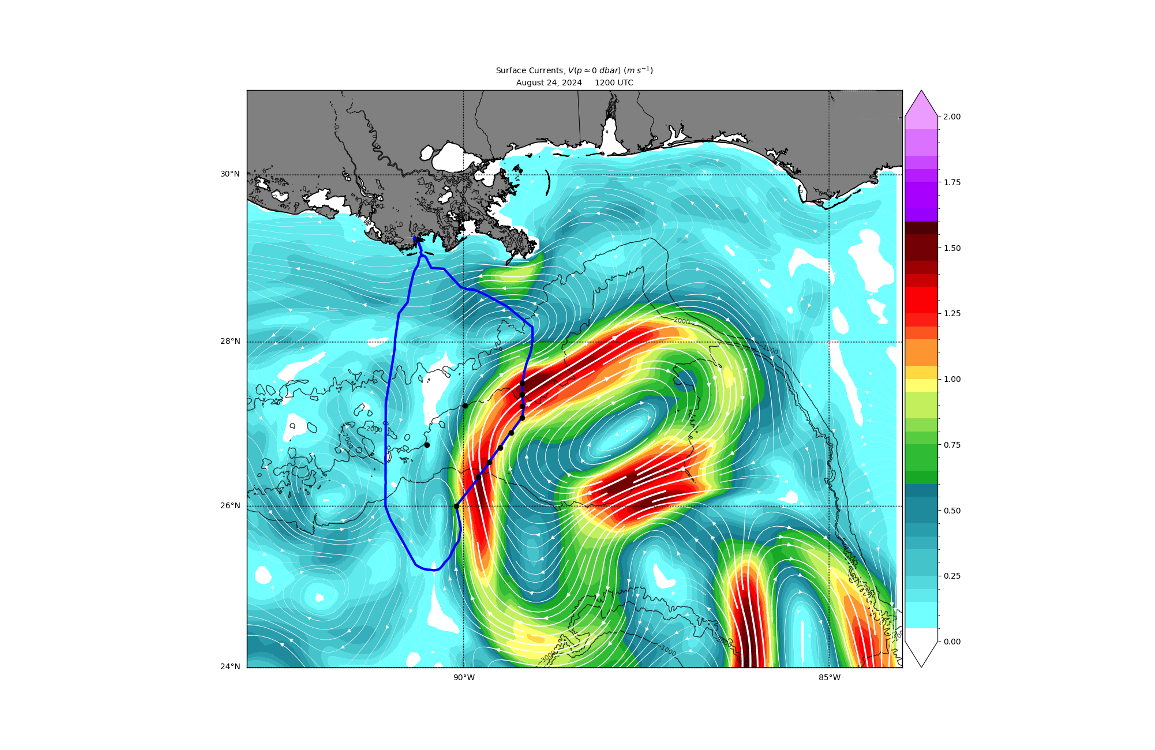
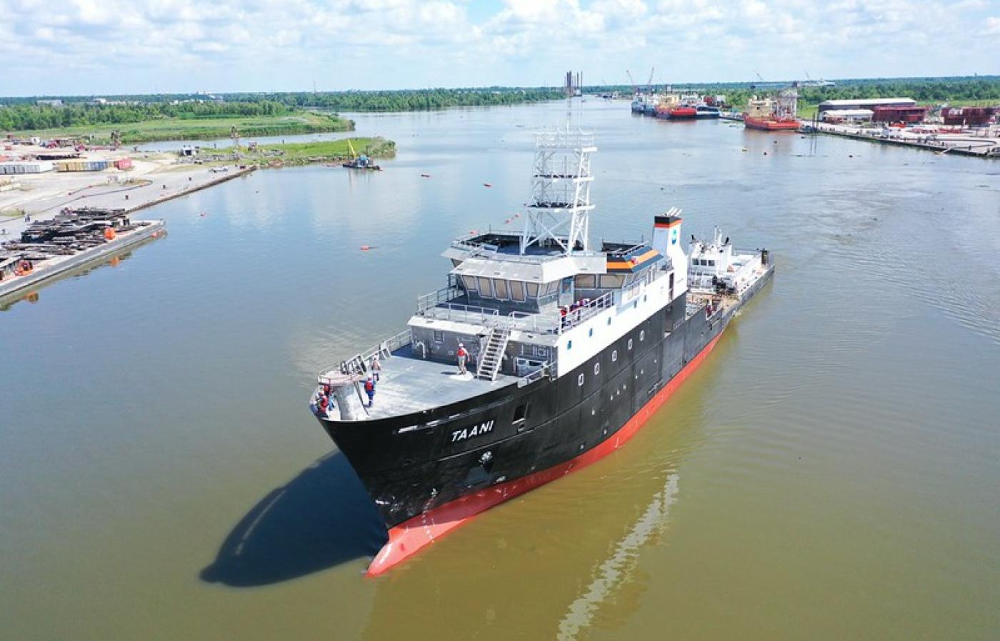
US Gulf of Mexico: pushing boundaries in challenging waters

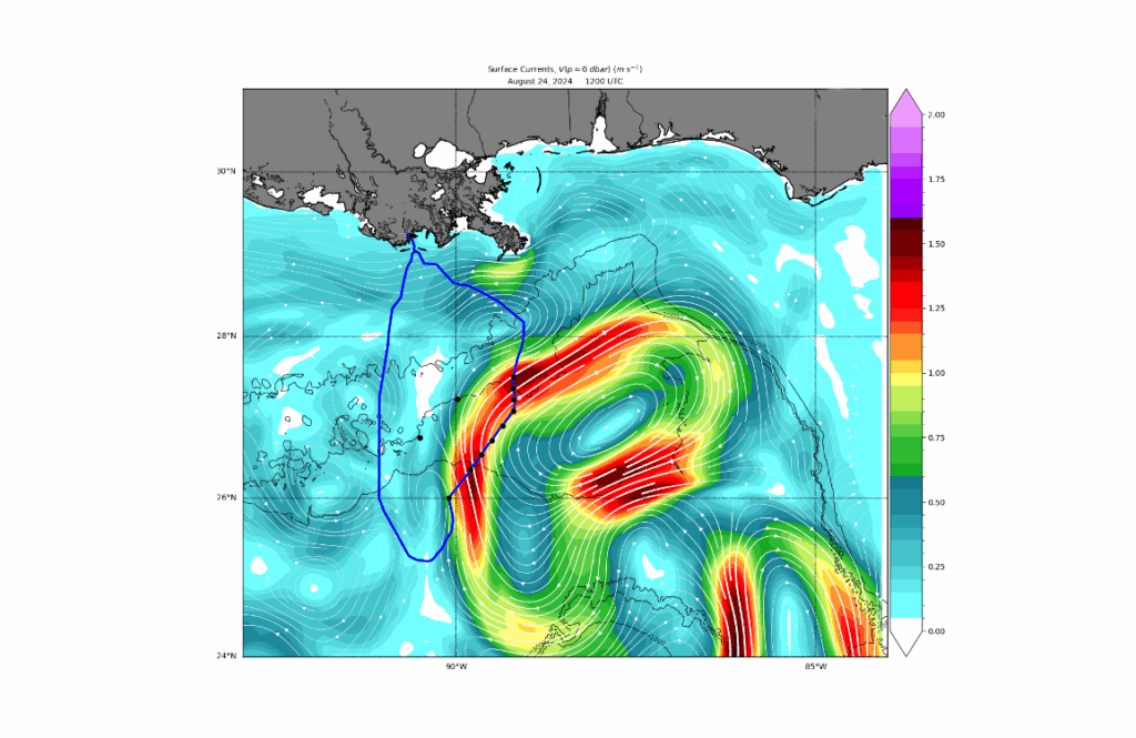
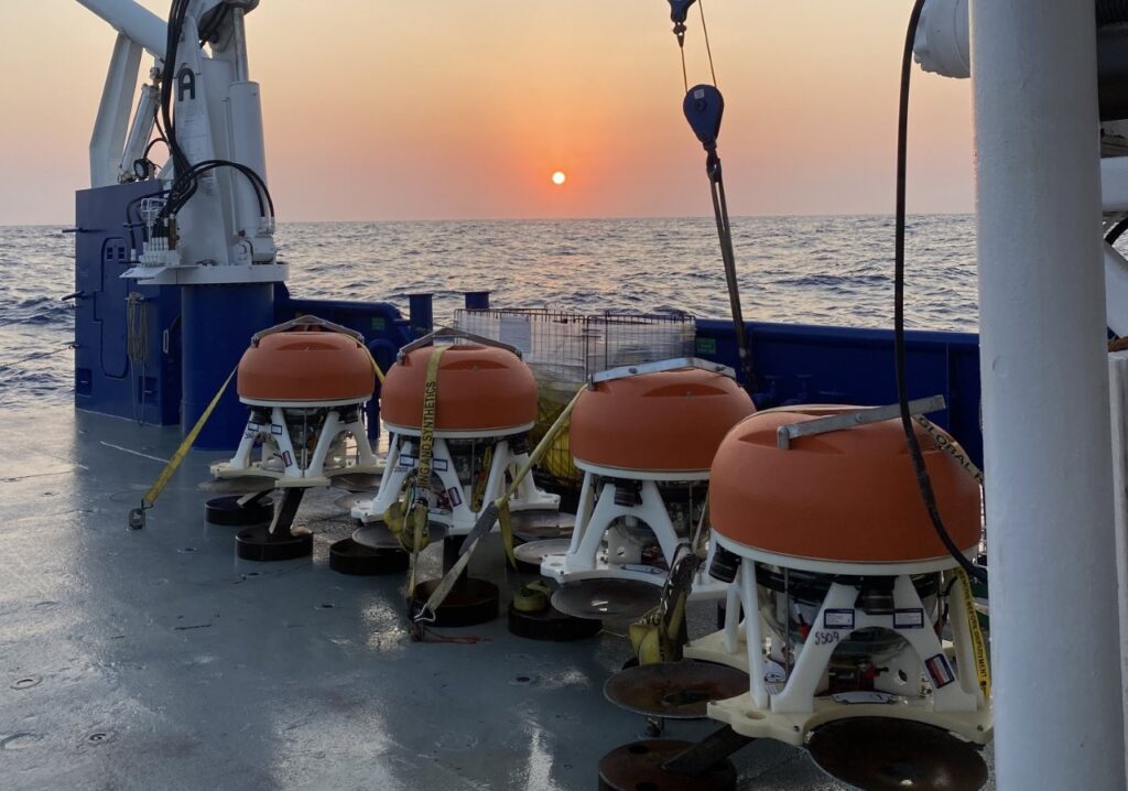
Perhaps the most demanding test of this technology came in the notoriously challenging waters of the US Gulf of Mexico’s Loop Current System (LCS). Here, SeaTrac‘s solar and battery-powered SP-48 USV, equipped with our HPT 7000L, has performed three separate missions, each over more than 580 nautical miles, to harvest data from nine deep-water sensors. This included our Origin 65 acoustic Doppler current profilers (ADCPs) and Current Pressure Inverted Echo Sounders (CPIES). 

The mission faced the additional challenge of the LCS’s notoriously strong currents and fast-moving eddies, yet succeeded in collecting crucial data from sensors positioned at depths between 1,800 – 3,200 m. 

“This successful mission marks a significant milestone in our mission to revolutionise ocean data collection,” says Hobie Boeschenstein, Director of Operations and Business Development, SeaTrac.  

“By leveraging our USV technology and Sonardyne’s acoustic expertise, we’ve proven that unmanned systems can safely and efficiently gather critical oceanographic data, paving the way for a more sustainable future of marine research. 

A triple win: cost, safety and sustainability

Across all three operations, the benefits our product innovations enable are clear and consistent: 


  • Reduced carbon footprint: From AutoNaut’s wave-propelled vessel to SeaTrac’s solar-powered USV, these solutions eliminate the emissions associated with traditional research vessels. 
  • Enhanced safety: By removing the need crewed ships to venture into challenging offshore environments, these uncrewed solutions eliminate personnel risk entirely. 
  • Real-time data access: Unlike traditional methods where data might only be available after a vessel returns to port, these solutions can enable immediate transmission of information to onshore teams. 
  • Lower operational costs: As with all innovative technology, early adoption and initial set-up costs mean that it is not always the most immediately economical option. But as demand increases and the technology develops, the future economic benefits will be substantial. Autonomous operations will significantly reduce the expenses associated with crewed vessel deployments.

“The use of wave or solar-powered USVs for zero carbon data gathering operations on these scales is a key moment in marine robotics,” says Aidan Thorn, Sonardyne’s Business Development Manager for Marine Robotics.  

“Our ocean presents some of the most challenging environments for any vessels, not least uncrewed ones. We are proud to be at the forefront of the technology with enables their operations.” 

A blueprint for the future 

As climate concerns intensify and technology continues to advance, our pioneering work provides a blueprint for how critical ocean monitoring can continue – and even expand, spatially and temporally – while reducing environmental, safety and financial impacts. 

“Moving from crewed to uncrewed vessels for such operations enables the drive to reduce carbon emissions in marine industries,” adds Thorn. “Similar remote data collection solutions can be realised in any marine operation that requires long-term data collection. 

“With successful deployments in the Atlantic Ocean, Norwegian Sea and Gulf of Mexico – each presenting unique challenges – we have demonstrated that zero-carbon data harvesting isn’t just a promising concept but a practical reality ready for widespread adoption.” 

For industries ranging from offshore energy production to long-term environmental research, the message is clear: the future of ocean data collection has arrived and it’s sustainable, safer and more efficient than ever before. 

Offshore service provider OS Energy has adopted Sonardyne’s SPRINT-Nav DP high-grade dynamic positioning (DP) reference system to support its marine renewable energy projects in the North and Baltic Seas.  

SPRINT-Nav DP will enable OS Energy to maintain DP integrity, even in shallow water and GNSS-compromised environments that are increasingly characteristic of offshore wind construction and maintenance activities.  

Housed within a single, pre-calibrated unit, the easy to integrate system allows operators ride out GNSS disruption, maintaining safety, accuracy and DP certification.   

It does this thanks to its integrated high-grade inertial navigation and Doppler velocity log (DVL) technology, providing the capability to acquire accurate seabed-referenced positioning, even when other position reference systems (PRSs) fail. 

See how SPRINT-Nav DP performed in vessel trials

Germany-based OS Energy is a specialised offshore service provider with more than 15 years’ experience in offshore wind, offering vessel management, survey, inspection and environmental monitoring. 

The SPRINT-Nav DP units will be deployed on the newbuild offshore survey and service vessels (OSSVs) that OS Energy has designed specifically for working within wind farms in the North and Baltic Seas.  

The innovative DP2 OSSV design integrates a hybrid powertrain and distribution system capable of operating on zero-emission alternative fuels. 

OS Energy has confirmed three with options for a further three vessels. The first vessel is being built at the Danish Esbjerg Shipyard with delivery expected in 2026.

OS Energy’s Managing Director Vincent Nuernberg says, “The technical capability provided by SPRINT-Nav DP aligns directly with our mandate to deliver secure and efficient marine operations for offshore wind. As projects grow in technical complexity and regulatory scrutiny, reliable DP systems underpin safe and repeatable outcomes in the field.” 

“We’re seeing operators experiencing persistent challenges around position reference system availability and GNSS signal interference, especially near turbine arrays and marine infrastructure,” says Duncan Rigg, Business Development Manager, vessel systems, at Sonardyne.  

“By ensuring uninterrupted DP operations, using SPRINT-Nav DP, our customers can stay on-task, maintain compliance with industry standards and, ultimately, enhance project delivery.” 

Learn more about how GNSS spoofing and jamming is an increasing headache for DP vessel operators.

What is SPRINT-Nav DP?

The offshore industry is at a critical juncture. As operations expand into more challenging environments and regulatory requirements become increasingly stringent, traditional dynamic positioning (DP) systems are showing their limitations.

For shallow water operators, managing heavy lift vessels, supply operations and construction projects, maintaining DP2 compliance while dealing with GNSS interference, environmental restrictions and operational complexity has become a daily struggle.

Recent sea trials in the Malacca Straits aboard the MV Bloemgracht, a next-generation DP2 heavy lift vessel, have demonstrated a game-changing solution that addresses these challenges head-on: SPRINT-Nav DP.

A paradigm shift: true independence in dynamic positioning

SPRINT-Nav DP represents a fundamental shift in how we approach dynamic positioning. Unlike traditional systems that rely on external infrastructure or vulnerable GNSS signals, SPRINT-Nav DP achieves true independence through intelligent sensor fusion.

The system combines a high-altitude Doppler velocity log (DVL), precision inertial sensors and an accurate pressure sensor in a single, factory-calibrated housing.

This integration eliminates the need for seabed beacons, transponders or fixed targets – infrastructure that is often impractical, expensive or environmentally restricted in shallow water operations.

Real-world performance: the Bloemgracht trials

The trials demonstrated the practical benefits operators can expect:

Extended operating envelope: Testing confirmed reliable operation in water depths up to 225 m over sandy seabeds, with expectations for even greater depths over harder substrates. This coverage encompasses most continental shelf operations.

Exceptional accuracy: During comprehensive FMEA box  manoeuvres in 200 m water depth, SPRINT-Nav DP maintained position correlation with GNSS to within 0.5 m– well within DP2 operational requirements.

Long-duration reliability: Perhaps most impressively, during a 1.5-day station-keeping test with GNSS disabled, the system maintained position accuracy within 2 m peak difference from the reference.

This performance level ensures that operators can maintain compliance even during extended operations where traditional references might be compromised.


Strategic advantages for shallow water operators


  • Operational flexibility – SPRINT-Nav DP’s independence from external infrastructure means vessels can maintain DP2 compliance in locations where traditional acoustic positioning systems cannot be deployed. This flexibility opens new operational possibilities and reduces the constraints that often drive project costs and timelines.
  • Environmental compliance – Operating at 375 kHz – outside the frequency ranges considered harmful to marine mammals – and requiring no seabed deployment, SPRINT-Nav DP enables operations in environmentally sensitive areas where traditional systems would be restricted or prohibited.
  • Simplified installation and operation – The system’s factory calibration and minimal vessel-specific calibration requirements translate to reduced installation time and complexity. For operators managing multiple vessels or frequent mobilisations, this simplification delivers significant cost and time savings.
  • Enhanced safety through redundancy – By providing a truly independent position reference that doesn’t rely on the same infrastructure as other DP systems, SPRINT-Nav DP strengthens the redundancy that DP2 and DP3 operations require.
  • Beyond positioning: added value through water current profiling – SPRINT-Nav DP’s dual functionality as an acoustic Doppler current profiler (ADCP) provides operators with valuable environmental data that can optimise operations and enhance safety. The system’s ability to measure water currents while compensating for vessel motion delivers actionable intelligence about subsea conditions that traditional vessel-mounted ADCPs cannot provide.

During the Malacca Straits testing, the system revealed complex current profiles with significant variations through the water column – intelligence that can inform operational planning, improve safety and optimise fuel consumption through better understanding of environmental forces.

ADCP data showing significant flow at 60m water depth


The economic case for independence

For shallow water operators, the business case for SPRINT-Nav DP extends beyond technical capability to fundamental operational economics:


  • Reduced mobilisation costs: No need for survey vessels to deploy acoustic beacons
  • Eliminated demobilisation requirements: No equipment recovery operations
  • Expanded operational windows: Ability to work in areas where traditional systems cannot
  • Enhanced project certainty: Reduced risk of DP reference failures impacting schedules
  • Simplified logistics: Single system installation with minimal ongoing maintenance

Looking forward: the future of independent DP

As the offshore industry continues to push into more challenging environments and face increasing operational complexity, the need for truly independent positioning systems will only grow. SPRINT-Nav DP represents not just an evolutionary improvement in DP technology, but a fundamental reimagining of how dynamic positioning can be achieved.

For shallow water operators, particularly those managing heavy lift operations, construction support, and complex offshore projects, SPRINT-Nav DP offers a pathway to enhanced operational capability and improved safety margins.

The successful trials aboard the MV Bloemgracht demonstrate that this technology is not a future possibility – it’s an operational reality today.

As operators seek to maintain competitive advantage in an increasingly challenging market, the question isn’t whether independent DP systems like SPRINT-Nav DP will become standard – it’s how quickly forward-thinking operators will adopt them to capture the competitive advantages they offer.

The era of truly independent dynamic positioning has arrived. For shallow water operators, the opportunity to break free from traditional constraints and unlock new operational possibilities is available now.

Want to find out how SPRINT-Nav DP could support your next mission? We’re here to help you navigate.

What is SPRINT-Nav DP?