Sonardyne
Support Centre

Case Study:

Energy Blog

Author:

Colin Sutherland Market Development Manager - Survey

How vessels can hold position when GNSS doesn’t

20052026

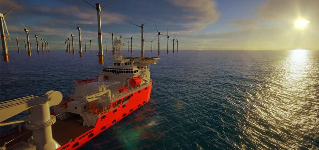
Out offshore, a vessel has one job when it comes to positioning: to know exactly where it is. Whether installing wind turbines, supporting subsea construction, carrying out inspection or manoeuvring inside a controlled zone, dynamic positioning (DP) allows a vessel to hold position, heading and manoeuvre within tight tolerances for hours — sometimes days — at a time. When it works, it’s invisible. But DP is only as good as the position data it receives.

The problem: when position can’t be trusted 

For years, GNSS has been the foundation of offshore positioning. When satellite signals are available and reliable, DP systems perform exactly as intended. But offshore environments are changing. 

Signals are now routinely blocked by structures, degraded by interference or jammed or spoofed.  Take a look at our knowledge base article which explains the difference between jamming and spoofing.

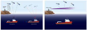
Inside offshore wind farms, near large installations, or in contested regions, GNSS disruption is no longer unusual — it is expected. And when GNSS becomes unreliable, the consequences are immediate. 

Vessels lose confidence in their position. Operations slow down or stop. Projects are delayed. In some cases, vessels are taken out of operation entirely. The problem is no longer just losing GNSS — it’s losing trust in position itself. 

Why this matters: the risk behind the problem 

GNSS denial does not always present as a complete outage. Sometimes the signal drops out. Sometimes it drifts. Sometimes it appears valid — but is wrong. For a DP vessel, that uncertainty is critical. 

Position is not just navigation. It underpins safety, compliance and operational continuity. When position cannot be trusted, neither can the operation. 

The guide: a different way of thinking about position 

This is where a different approach is needed. If there is one thing Sonardyne is known for, it is supporting critical offshore operations and high-accuracy subsea survey. Historically, these worlds have operated slightly apart, with survey systems focused on seabed-referenced precision and DP operations relying heavily on GNSS. 

Many operators will recognise Sonardyne technologies individually — LBL, USBL, inertial navigation — each solving specific positioning challenges. But the real shift is not in the individual technologies. It is in how they are used together. 

Instead of relying on a single source of truth, positioning can be built from multiple independent systems. Inertial navigation, acoustic positioning and seabed-referenced methods can be combined to provide what is increasingly described as positioning assurance — confidence that position remains valid, even when GNSS does not.

The plan: how vessels hold position without GNSS 

For DP operations, this approach can be applied in several ways, depending on the environment and the task. 

In shallow water, systems such as SPRINT-Nav DP provide a direct solution. By measuring vessel motion and velocity relative to the seabed using inertial sensors and Doppler velocity log (DVL) technology, the system can maintain accurate positioning without relying on satellites. Within approximately 230 m of the seabed, this allows vessels to operate entirely independently of GNSS. 

In practical terms, even without an external reference, movement can still be detected and controlled. SPRINT-Nav DP applies this principle with the precision required for DP operations, enabling vessels to remain on station even during complete GNSS outage. 

Where acoustic infrastructure is already in place, or planned as part of a project, additional resilience can be achieved without significant change to operations. Using systems such as Fusion 2, seabed array positions can be calibrated once and then shared across multiple vessels. These positions can be fed into our Ranger 2 USBL system, providing a seamless transition to GNSS-denied operation. 

This approach not only maintains positioning capability, but also improves efficiency, allowing infrastructure to be reused across campaigns rather than deployed vessel by vessel. 

Acoustic positioning systems themselves provide a further independent layer. Operating underwater using sound rather than radio signals, they remain unaffected by GNSS interference, including jamming and spoofing.

From simple USBL systems on offshore support vessels to fully redundant drillship configurations combining USBL, seabed transponders and inertial navigation, these systems have long supported DP operations.

What has changed is not their capability, but their importance. As GNSS disruption increases, acoustic positioning is no longer just supporting DP — it is becoming central to it.

The shift: when GNSS denial becomes normal 

In some regions, GNSS disruption is not occasional — it is assumed. This is driving the adoption of seabed-referenced positioning networks, where acoustic nodes create a stable reference frame beneath the surface. Operating in a quieter and more stable environment, these systems provide consistent and repeatable positioning over long periods. 

For operations that require vessels to return to the same location with high confidence, or maintain position over extended durations, this provides a level of reliability that GNSS alone can no longer guarantee. 

The outcome: what success looks like 

The offshore industry is already seeing the consequences of GNSS disruption — lost vessel time, delayed projects and increased operational risk. The difference now is how operators respond. 

Those who continue to rely on GNSS alone face increasing uncertainty. 

Those who adopt a multi-layered approach to positioning gain something more valuable than accuracy — they gain confidence. 

By combining inertial navigation, acoustic positioning and seabed-referenced systems, along with the suite of other position reference systems available on the vessel, ensure a vessels can continue to operate safely, maintain compliance and deliver projects on schedule, even when satellite signals cannot be trusted. 

Offshore, operations don’t have to stop just because GNSS does.