In 2007, a unique chapter in Sonardyne’s history began to be written – a chapter that would span the next 10 years and lead to the development of a completely autonomous and long endurance seafloor monitoring capability.
Shaun Dunn, Global Business Manager, and Tom Bennetts, Project Manager at Sonardyne look back at a unique subsea engineering challenge, how it was overcome and supporting a reservoir surveillance campaign that saw over 600 million measurements collected.
 It began with a challenge set by Shell geophysicists, Stephen Bourne and Paul Hatchell. They were looking for a method of precisely measuring potential movement of the seabed caused by reservoir depletion in the newly commissioned Ormen Lange deep water gas field, located hundreds of metres beneath the surface off the coast of Norway.
Subsidence measurement on land is comparatively easy because satellite positioning systems such as GPS provide highly accurate and repeatable measurements over long timescales. In the ocean it’s much harder, since electromagnetic waves are attenuated by salt water so GPS and optical survey techniques are not possible.
Therefore, a totally new solution was required and as we reported at the time in Baseline Issue 5, Stephen and Paul set us a very demanding brief. They were looking for subsea technology that could be deployed for many years without intervention, make hundreds of millions of stable highly precise measurements from a number of sensors, safely log the data and on command, wirelessly transmit the data to the surface.
Understanding the problem
Extracting hydrocarbons from a reservoir lowers the pore-pressure of the formation that contains the oil or gas, weakening it to a point where it might not be able to adequately support the rock layers above it. In earth sciences, this layer is known as ‘the overburden’. If measured accurately enough, the small, but detectable, changes to the surface of the overburden can be used by geophysicists to provide valuable insight into the rate of subsidence and other dynamic properties of the reservoir.
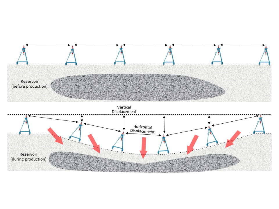 Because deformation manifests itself as both vertical and horizontal seabed displacements, it quickly became apparent that these movements could be measured using a network of our acoustic transponders acting as ‘seabed monuments’ placed both within and outside of the expected subsidence region.
Acoustic signals can be used for the purpose of measuring horizontal displacement by transmitting signals between pairs of transponders separated by several hundred metres and then accurately measuring the two-way round trip time. Since we can also measure the acoustic wave speed using sound velocity (SV) sensors built into each transponder, we can convert time and speed into distance and therefore continuously monitor for changes to the separation, known as strain rate, between many pairs of transponders.
Vertical displacement can be measured using integral pressure sensors and the results from multiple transponders can be compared and therefore the effects of tide, water column density and barometric pressure changes which are largely common to all instruments over long timescales can be removed from the data, leaving only the seabed depth changes remaining.
Precise ranging, acquisition of sensor data and telemetry is a common element of many subsea applications, so much of the engineering effort for the Ormen Lange project focussed on delivering the required endurance – which at that time was much longer than users typically required – and transponders that were capable of running a fully automatic data gathering and logging regime without intervention.
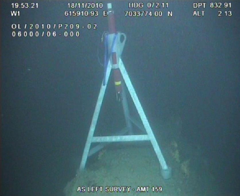
These requirements were met with the development of the Autonomous Monitoring Transponder (AMT) – a 3,000 metre depth rated instrument fitted with a range of sensors, wireless communications and a five year battery life.
Trial deployment
Keen to witness its capabilities, includingranging precision and long term pressure sensor performance, a small scale field trial of 10 AMTs was commissioned at Ormen Lange later that year. The AMTs were mounted in three metre tall tripod frames mand deployed to the seabed by ROV.
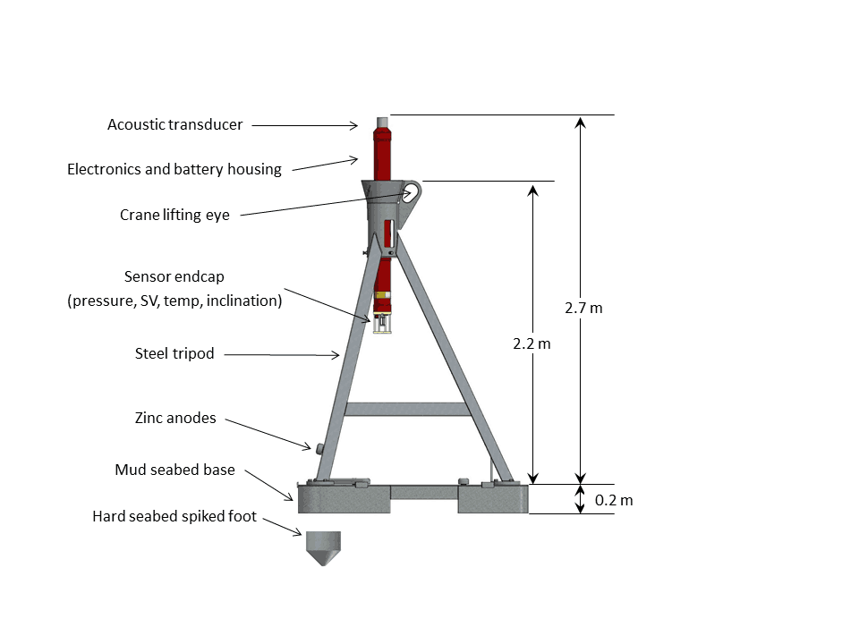 Conscious that any horizontal movement could affect the quality of the results, the AMT tripod was designed to be ‘heavy’ with the option of spiked feet for mounting on rocky terrain or a ‘mud skirt’ to reduce settlement into a soft seabed.
An initial 250 days of acoustic traveltime, pressure, sound velocity, temperature and inclination data was wirelessly recovered to the surface and handed to Shell for processing. Analysis of around 500,000 travel time, 60,000 sound velocity and around 10,000 pressure measurements demonstrated a range repeatability of around 5mm/km and drift in depth data in the order of 20mm/year. Results from this trial deployment were considered to be sufficiently encouraging to justify a longerterm field-wide subsidence monitoring campaign at Ormen Lange.
Full scale deployment
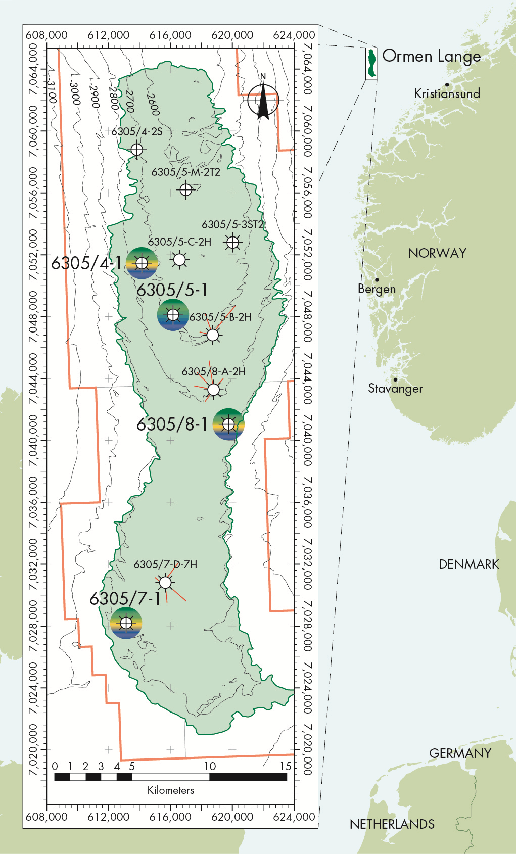
As the northern field was both the least developed area in 2010, and was also perceived to have the highest risk of deformation, it was decided to focus a field-wide network in this area such that the data would have the highest potential business impact to Shell and its asset partners. A narrow strip of sensors was also added to provide insight into the reservoir connectivity, pressure baffles and compartmentalisation over the saddle area between the southern and northern part of the field.
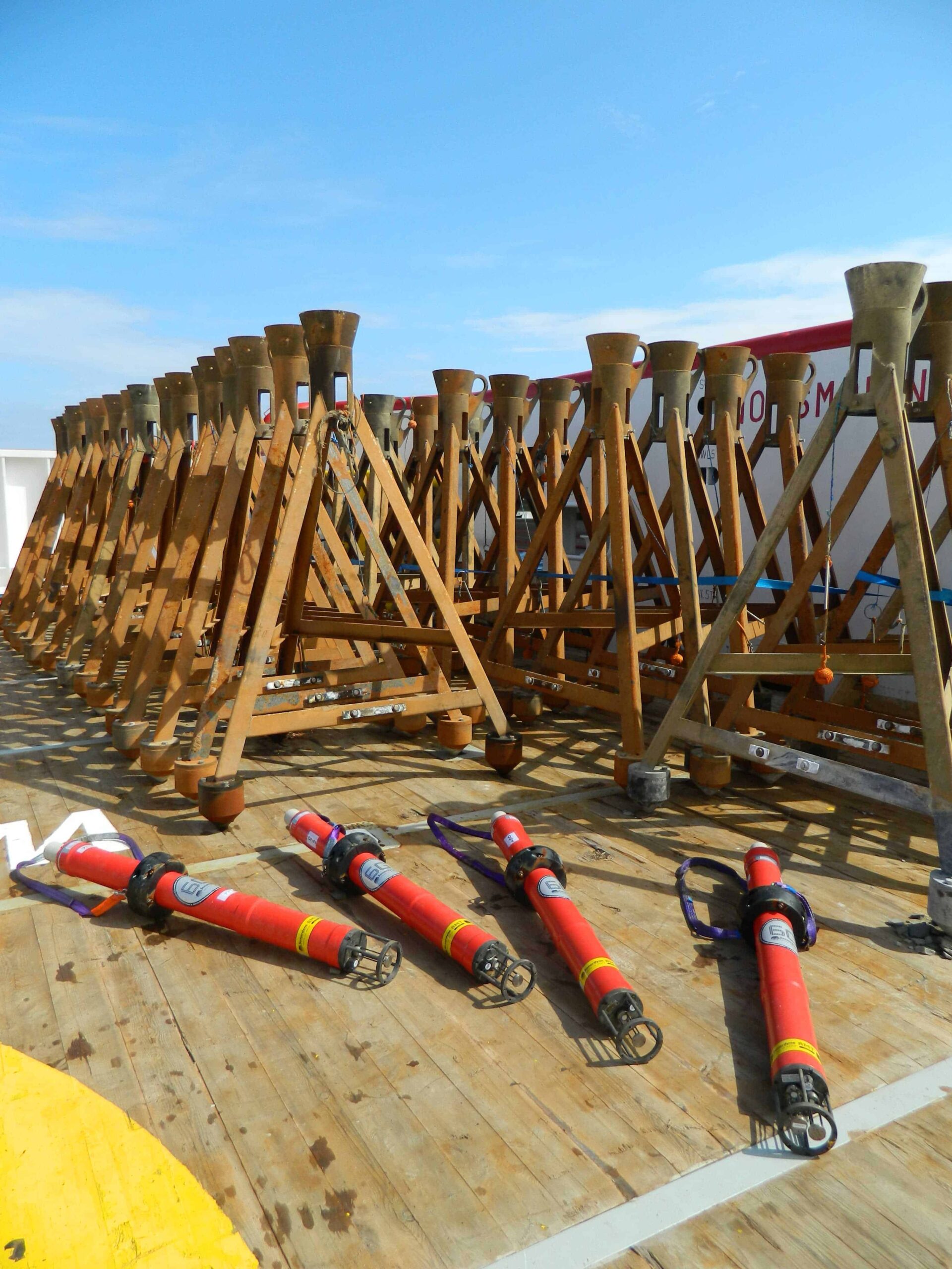
 The next task was to perform a terrain assessment across the region to identify suitable deployment locations for each AMT that would avoid line of sight obstructions and therefore ensure successful range measurement. This work was carried out by our Survey Support Group and their resulting deployment plan proposed 138 AMT units for the main northern subsidence region, 34 units for the trussed stripe going from north to south, and four stationary controls placed well outside the main array.
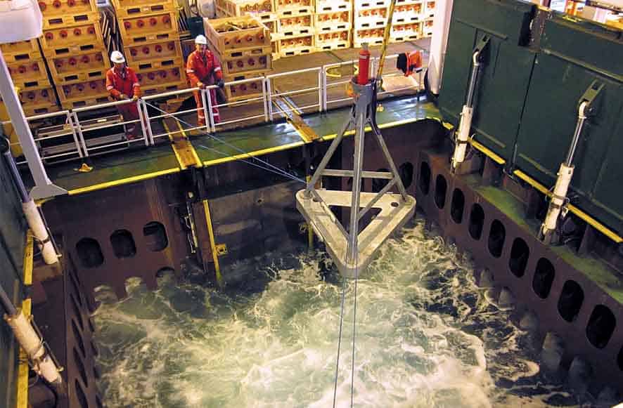
Having determined the AMT array plan, all the instruments were manufactured and deployed within the very short Norwegian summer weather window. Using a vessel-ofopportunity, each AMT was lowered by crane to the seabed and moved into its final position using an ROV.
Data harvesting and recovery
The Ormen Lange AMT array was programmed to gather range, pressure, SV and temperature and tilt data at threehourly intervals. Each AMT wakes up and acoustically interrogates several neighbouring AMTs in order to precisely measure the distance between each unit.
These ranges, along with the environmental readings from the on-board sensors, were then stored to the AMT’s memory. The time-stamped data logged within each AMT was available for recovery at the surface via the integrated high-speed acoustic telemetry modem. On eight separate occasions, a vessel-of-opportunity was tasked with visiting the site and recovering data from where it was immediately sent to Shell whilst the vessel continued to move around the site.
In June 2016, after five and a half years of continuous operation, a final visit to the Ormen Lange AMT array was made – this time to recover all the transponders and bring the project to an end. This involved using an ROV to attach a crane hook to each AMT tripod from where they could be lifted from the seabed and on to the vessel.
Survey findings and looking ahead
The acoustic network data has been analysed in great detail by Shell geophysicists and used to obtain average deformation values over the period from October 2010 to May 2016. The data indicates the network is contracting at a maximum rate of around 10ppm/year in the centre of the field – equating to around 1cm of contraction per kilometre of seabed per year.
 The pressure data has been used to obtain subsidence estimates averaged over a period of one year. Individual AMT stations subside by up to 3.5cm/ year although there is some uncertainty in this result since drifts in the older generation pressure sensors used and residual noise on this data was observed to be quite close in magnitude to the measured subsidence signal.
When comparing the seafloor deformation data, a consistent picture of low subsidence rates was found to be in agreement with modelled predictions for Ormen Lange. The measured strain and subsidence rates of 5ppm/year and 2cm/year on average, were close to the sensitivity limits of this generation of equipment, but several promising improvements have been made to the sensors used and the AMT design since it was first developed in 2007, and it is expected to reach an overall sensitivity to horizontal strain and vertical subsidence of better than 5ppm/year and 1cm/ year in future deployments.