Industry leading mooring solutions supplier, SOFEC, Inc., has selected BMT and Sonardyne Inc., under their teaming agreement, to supply an innovative mooring monitoring system (MMS) for a major new deepwater development.
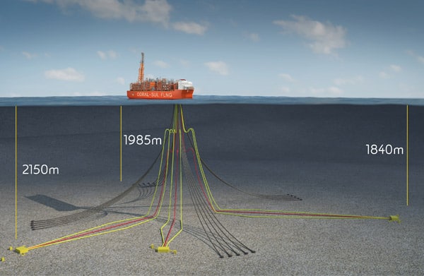
The new system will involve monitoring of the turret mooring system on a new-build floating liquefied natural gas (FLNG) facility being built in South Korea for ENI’s Coral South project offshore Mozambique. With water depths ranging from 1,500-2,300 metres, SOFEC, a MODEC Group company, wanted to integrate a robust and reliable MMS to complement their market leading turret mooring solution.
SOFEC chose to use BMT and Sonardyne’s combined engineering strength in order to acquire the most technically competent and robust MMS. Their selection was based on high data availability, ease of remote operated vehicle (ROV) installation, robustness of the subsea technology and the longevity between maintenance periods that the BMT / Sonardyne MMS offers, compared with other solutions in the market.
Above the waterline, BMT will supply the station-keeping turret monitoring system and local control panel with touchscreen interface. The control panel will also house Sonardyne’s topside equipment, to minimise the system’s footprint. Additionally, the system will allow SOFEC’s client to gain remote data access through BMT’s secure cloud-based portal, BMT DEEP.
Below the waterline, Sonardyne’s SMART (Subsea Monitoring, Analysis and Reporting Technology) will be used to constantly monitor mooring integrity on each of the 20 anchor legs. Daily summary reports and automatic fault detections will be wirelessly communicated to the surface from the SMARTs real-time.
Robert Barker, Offshore Commercial Manager at BMT, says, “We are proud to be supporting SOFEC with this work and the Coral MMS project represents a significant contract award. Our system will be providing valuable integrity data and important real-time monitoring of the mooring system to enhance operational safety.”
Stephen Auld, Global Business Manager, Subsea Asset Monitoring, Sonardyne, says, “Our SMARTs use fast burst and highly energy efficient acoustic telemetry, as well as ultra-low power electronics, reducing through-life costs for customers, and that was a real positive for SOFEC. For this project, we’ve also increased the time between battery replacement to in excess of six years, so it’s a long-life, easy to use system to ensure integrity data acquisition.”
We’re a long-term corporate patron of leading UK-based charity the Shark Trust, supporting its work globally to preserve the world’s shark populations. Ahead of World Oceans Day on Saturday, we invited the Shark Trust Managing Director Paul Cox to tell us – and you – about some of the issues the charity is addressing.
Author: Paul Cox, Managing Director, Shark Trust
 That plastic straw thing. It has a peculiar ability to both delight and dismay in equal measure. Coming from someone who spends their working life dedicated to marine conservation, how can a ban on plastic straws be anything but a good thing?
It’s great that a big sustainability issue has made it into the “mainstream” – using a plastic straw has gone from unremarkable to almost socially unacceptable in little over a year. But it feels to me a bit like misdirection. The future of our oceans doesn’t, sadly, hinge on banning plastic straws.
My hope is that the straw will become an icon, a symbol of the willingness to change. It’s not the conclusion of the story, but the beginning of a new chapter in how we deal with the ocean to which we owe so much.
An immediate threat
Alongside the plastic problem, there’s another, more immediate threat which isn’t getting the bandwidth that it deserves. And that’s overfishing. It’s not a complicated equation. We all know that if we spend more than we earn, things are going to go badly. You can get away with it for a while but ultimately, if you make a habit of it, then at some point you’ll get into trouble.
This problem is at the heart of overfishing. Think of the sea as a savings account. We inherited a lump sum which, as the fish reproduce, pays interest. Withdraw some or all of that interest and your nest egg is safe. Take more and your savings start to shrink. When your savings shrink so does your interest.
In amongst that inheritance are some priceless antiques of nature: Sharks. They’ve been in the oceans for more than 400 million years and include some of the most vital, valuable and vulnerable species in our seas.
At risk of extinction
Sharks are also particularly vulnerable to overfishing. They’re slow and thrifty at reproducing. They pay a low rate of “interest”, so they should be fished with caution. But they’re not. They’re being taken in high numbers and, for too many species, at a rate beyond their ability to replace themselves. The last comprehensive analysis by the International Union for Conservation of Nature (IUCN) Red List of Threatened Species estimated that over a quarter of the 1000+ species of sharks and rays that exist are at risk of extinction. This includes some of the most well-known and well-loved sharks.
If we’re to avoid bankruptcy, we need to act fast. The Shark Trust is the UK charity that works globally to safeguard the future of sharks and rays. Transforming fisheries to sustainability is a core goal and the we work with a range of international partners to achieve positive change.
Through various projects and campaigns the we’ve been a leader for more than 20 years in taking a sensible line on shark conservation and always placing science at the heart of decision-making. Our work cuts across governments, policymakers, industry and businesses. We find constructive solutions and drive best practice wherever sharks and people meet.
Targeting uncontrolled shark fisheries
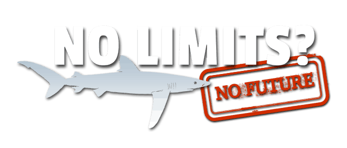
Our No Limits? campaign targets an end to uncontrolled shark fisheries – in Europe and on the high seas. We’re determined that shark fisheries should implement science-based catch limits to prevent continued overfishing.
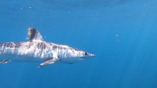
The plight of the Shortfin Mako – the world’s fastest shark – demonstrates the importance of this effort. This stunning shark, recently re-assessed as Endangered by the IUCN, has been heavily overfished in the Atlantic. In 2017, scientists estimated that, even if catches were cut to zero, North Atlantic Shortfin Makos would only have a 54% chance of recovery by 2040. Despite this dire prediction and the clear need for a prohibition, the species continues to be fished. Despite a red letter from the bank, the spending continues.
It’s not either/or. Overfishing, climate change, plastics and other issues work hand in hand. If populations are stressed by continued overfishing then they lack the resilience that they might otherwise have to deal with a changing environment. There is no single solution to safeguarding the world’s oceans, but tackling overfishing is an urgent priority.
We are making progress, but we need to keep pushing. We’re committed to bringing as many people to the party as possible. We’re grateful for Sonardyne’s ongoing support, reflecting their vision and positive attitude towards sustainable use of our oceans. Everyone can get involved and everyone can be a positive influence on the future of sharks.
Find out more about sharks and how you can get involved www.sharktrust.org/getinvolved
Images:
Shortfin Mako shark, copyright Nicolas Authier (CC BY-NC), https://www.inaturalist.org/photos/35510241
Shortfin Mako shark, copyright Alison Kock (CC BY-NC), https://www.inaturalist.org/photos/37399944
Leading seismic monitoring instrumentation and solutions provider Güralp Systems Ltd. and Sonardyne International Ltd. have signed an agreement to cooperate in the provision of cutting edge multidisciplinary ocean bottom research technology, including capabilities for earthquake or tsunami detection.
The official Teaming Agreement between Güralp and Sonardyne, announced at the European Association of Geoscientists and Engineers (EAGE) conference in London today (June 4), will enable the two companies to collaboratively provide more advanced and efficient technology for in-situ seismic and seabed monitoring.
Güralp has more than 30 years’ experience in the design and manufacture of broadband seismometers and accelerometers, while Sonardyne’s experiences stretches to more than 40 years of experience in long-endurance data collection and through-water telemetry. As a consequence, clients globally will benefit from a combined offering of technology for seismic data gathering, seabed deformation monitoring and tsunami detection, as well integrated acoustic positioning and telemetry for remote data access.
At the heart of the cooperation is Güralp’s revolutionary new Aquarius Ocean Bottom Seismometer (OBS). Comprising of a digital feedback tri-axial broadband seismometer, three-axis magnetometer, a micro-electric mechanical system (MEMS) accelerometer and absolute pressure gauge, Aquarius is also equipped with Sonardyne’s 6G Wideband low-mid frequency (LMF) acoustics.
The low profile and compact design of the Aquarius minimises flow noise, but also makes it the most compact telemetry-enabled OBS available in the market. Available in two variants, the Aquarius is capable of 12 or 18 month deployments depending on the system options selected. These options include instrument configuration, transmission of state of health and triggered event or snippet data transmission at up to 9,000 bps.
6G-inside capability also means that Aquarius is compatible with a range of other Sonardyne technologies, including Ranger 2 Ultra-Short BaseLine (USBL) positioning and telemetry, as well as its unmanned surface vehicle (USV) GPS-Acoustic payload box and Tsunami Detection System.
Both companies have global reputations for provision of class-leading technology to academic, public, governmental and private organisations for understanding and exploring our world. As a consequence Güralp and Sonardyne are confident that closer cooperation will lead to a further step-change in the solutions available to customers.
Geraint West, Global Business Manager, Ocean Sciences, Sonardyne, says, “We really welcome closer cooperation with Güralp. Our overlapping markets and complementary technologies mean that we have the potential to transform what we can individually offer to our customers.”
[blockquote author=” Neil Watkiss, Commercial Director, Güralp”]”The Sonardyne technology that we are utilising in the Aquarius is allowing us to re-define what is possible with broadband OBS. This agreement offers potential for further exciting product advancements on both sides and we look forward to further exploring the possibilities with the Sonardyne team.”[/blockquote]
You can find Sonardyne on stand 855 during EAGE (June 3-6).
Integrated navigation, positioning and communications technology from Sonardyne Inc. will support a new, fuel cell-powered long-range unmanned underwater vehicle (UUV) being designed by subsea specialist Cellula Robotics Ltd. for the Canadian defence department.
The UUV, called Solus-LR, is being designed to be able to travel up to 2,000 kilometres and stay submerged on multi-month missions, supported by an onboard fuel cell power pack. To help meet these demanding long-duration and long-distance navigational requirements, Cellula Robotics has ordered one of Sonardyne’s high-performance SPRINT-Nav subsea navigation instruments for the Solus-LR.
SPRINT-Nav, which combines a SPRINT INS, Syrinx 600 kHz DVL and a high accuracy intelligent pressure sensor in a single housing, is one of the smallest and the highest performing combined inertial navigation instruments on the market.
For tracking the vehicle from the surface, receiving data packets from it and sending mission commands to it, Cellula Robotics has also ordered a Micro-Ranger 2 Ultra-Short BaseLine (USBL) system with optional Marine Robotics software feature pack, and an AvTrak 6 combined transponder and telemetry transceiver, which will be integrated into the UUV. Micro-Ranger 2 is Sonardyne’s most compact underwater target tracking system, built around the company’s 6G hardware and Wideband 2 digital acoustic technology platform which delivers consistently in any operational scenario.
Sea trials of the Solus-LR, which are expected to start in late 2019, running through to early 2020, will also be supported by the use of Sonardyne’s Compatt 6 seabed transponders and the company’s BlueComm 200 underwater optical communication instruments. BlueComm 200s are able to transmit high-bandwidth data, including video, at up to 150 metres. The trials will be held in the Indian Arm fjord, near Vancouver, British Columbia, close to Cellula’s Robotics’ headquarters.
Solus-LR is being built for the Canadian Department of National Defence’s (DND) science and technology organization, Defence Research and Development Canada (DRDC), under the All Domain Situational Awareness (ADSA) Science & Technology (S&T) Program. The ADSA S&T program is supporting projects which could help to enhance domain awareness of air, maritime surface and sub-surface approaches to Canada, in particular those in the Arctic.
[blockquote author=” Eric Jackson, President of Cellula”]”This S&T program will showcase Cellula’s advanced UUV research and development, combining traditional technologies with innovative power and anchoring solutions. With Solus-LR able to travel for thousands of kilometers, port to port missions will become a feasible lower-cost alternative to vessel-based operations.”[/blockquote]
Oceaneering International Inc. has ordered hybrid navigation systems from underwater technology specialist Sonardyne Inc. for its subsea resident vehicles Freedom and E-ROV.
The two resident vehicle systems are to be fitted with SPRINT-Nav our all-in-one navigational instrument. SPRINT-Nav combines a SPRINT INS sensor, Syrinx 600 kHz DVL (Doppler velocity log) and a high accuracy intelligent pressure sensor in a single unit, making it one of the smallest and highest performing combined inertial navigation instruments on the market.
Oceaneering’s E-ROV has already proven the ability for battery-powered remotely operated vehicles (ROVs) working in the oil and gas industry to be piloted from shore, via 4G mobile broadband transmitted from a buoy, independent of support vessels. The company’s next-generation resident hybrid ROV Freedom builds on the E-ROV concept. Due to debut in offshore trials later this year, Freedom is targeting long, maintenance free-deployments, on autonomous missions and with support from shore-based pilots.
The vehicle will be based out of docking stations on the seabed, enabling it to recharge and download data before and after its subsea inspection, maintenance and repair missions. It will operate in tethered and autonomous tetherless modes, performing both AUV and ROV-related tasks, including survey, inspection, torque tool operation and manipulator-relator activities.
[blockquote author=” Jami Cheramie, Oceaneering”] Both of these systems have been developed to drive a step-change in inspection, repair and maintenance operations in subsea oil and gas fields, to help both increase uptime, operational flexibility and autonomy. A single hybrid instrument for their navigational needs.[/blockquote]
“Tight integration of the separate sensors within SPRINT-Nav as well as the use of high-specification Ring Laser Gyros are behind the high performance our customers are seeing from these units. Combined with their compact form factor, these results are seeing SPRINT-Nav fast becoming the INS instrument of choice for resident vehicles,” said Char Franey, Sales Manager for Survey and Construction at Sonardyne in Houston.
“They’re free from the calibration routines otherwise required and, because they also run on a unique dual engine algorithm, powering the INS and Gyro compass, initialisation is fast and gaps in navigation are few and far between. Thanks to these qualities, SPRINT-Nav is not only ideally suited to subsea resident vehicle applications, but also autonomous and unmanned underwater vehicle (AUV/UUV) navigation.”
A major new seabed observatory that will provide critical information about earthquake and tsunami hazards is to be deployed offshore Vancouver, Canada, using long endurance acoustic sensing technology supplied by Sonardyne International Ltd.
The new Northern Cascadia Subduction Zone Observatory (NCSZO) will use a “seafloor GPS” network to monitor long-term movements of the subducting Juan de Fuca plate and overriding North American tectonic plate. Data gathered by the new observatory will play a critical role in informing assessments of earthquake and tsunami risk to the large populations of the Pacific North-West.
The NCSZO is led by Ocean Networks Canada (ONC)—an initiative of the University of Victoria—and is made possible through cooperation of international partners that include Natural Resources Canada (NRCan) scientists at the Pacific Geoscience Centre and David Chadwell from the Scripps Institution of Oceanography. More than 20 Sonardyne Fetch subsea sensor logging nodes, which will be deployed in depths ranging from 400 to 2,500 metres of water depth for seven years or longer at a time, will comprise the backbone of the NCSZO.
Data will be acquired up to two times a year using a technique called GPS-Acoustic method (GPS-A), the commercial application of which has been pioneered by Sonardyne. GPS-A uses acoustic positioning techniques, inertial navigation, and GPS data to periodically position the Fetch instruments to centimetre-level accuracy, using a Sonardyne transceiver mounted on an unmanned surface vessel.
These measurements will enable the Fetch positions to be related to a corresponding onshore network of geodetic stations operated by NRCan, allowing the subsea plate motion and onshore plate motion to be correlated, which has only recently been made possible.
A number of Fetch units will also be connected to ONC’s existing 900 kilometre-long NEPTUNE cabled ocean observatory to study the potential for continuous measurements. Furthermore, the cabled units will include Sonardyne’s innovative Ambient-Zero-Ambient (AZA) functionality, which enables the instrument’s high quality pressure sensor to be automatically recalibrated in-situ, by periodically measuring the sensor bias against an integrated low pressure sensor.
Geraint West, Global Business Manager – Oceanographic, at Sonardyne, says, “Proven and low-risk, our Fetch instruments are a key tool for the international science community where they are changing the game for seabed tectonic studies. This deployment at the NCSZO, which will be one of the largest studies we have been involved with, further cements its track record.”
Kim Swords, Senior Applications Engineer for Sonardyne in Houston, says, “The data gathered is critical for understanding which areas of the plate interface in the Cascadia Subduction Zone are locked and whether or not part of the energy is being released by slow creep on the fault. Deeper locking that extends further to the coast results in stronger earthquakes in the large population centres of the Pacific North-West, while shallow locking, on the other hand, leads to bigger tsunamis.”
Martin Heesemann, Senior Staff Scientist, Science Services at ONC, says, “Data provided by the NCSZO are certain to enable major breakthroughs in the scientific assessment of earthquake and tsunami risks related to the Cascadia Subduction Zone. Moreover, Sonardyne’s Fetch technology will allow for world-class research in the geodynamics of subduction zones and major technological advances in the rapidly emerging field of seafloor geodesy.”
The project is supported by the Canada Foundation for Innovation, the British Columbia Knowledge Development Fund, and Natural Resources Canada.
The UK’s centre of excellence for oceanographic sciences, the National Oceanography Centre (NOC), has selected high-performance hybrid navigation technology from Sonardyne International Ltd. for the next generation of its Autosub autonomous underwater vehicle (AUV), targeted for under-ice operations.
The NOC, based in Southampton, will incorporate Sonardyne’s highest performing SPRINT-Nav inertial navigation system (INS) into the new 2,000 m depth-rated Autosub, which is being specifically developed for carrying high-performance sensors on the most demanding research missions under polar ice, hence its name Autosub2KUI, or A2KUI.
SPRINT-Nav combines Sonardyne’s SPRINT INS sensor, Syrinx 600 kHz DVL and a high accuracy intelligent pressure sensor into a single housing, making it one of the smallest combined inertial navigation instruments on the market. SPRINT-Nav’s tight integration of all the raw sensor data at a low level provides unprecedented navigational performance and precision for subsea vehicles. Consequently, SPRINT-Nav has consistently outperformed competing systems in trials carried out for a number of customers. The SPRINT-Nav 700, selected by the NOC, is equipped with the highest performance available sensors, including Honeywell ring laser gyros and accelerometers, and has a conservative quoted accuracy of 0.01% distance travelled (Typical Survey).
[blockquote author=” Geraint West, Global Business Manager Oceanographic, Sonardyne”]”NOC selected SPRINT-Nav 700 to meet its requirements for an advanced dead-reckoning system in a single unit as the backbone of the A2KUI’s navigation system. The capability to plug in other navigation sensors to aid the AUV’s position was also critical and a second upward-looking Syrinx DVL is being incorporated to provide tracking on the underside of the ice.”[/blockquote]
“A2KUI will also be equipped for acoustic tracking using Sonardyne’s Ranger 2 Ultra-Short BaseLine (USBL) system, which is fitted to the UK research vessels RRS James Cook, RRS Discovery and the new polar research vessel RRS Sir David Attenborough,” adds Geraint.
Dr Alex Phillips, Head of Marine Autonomous Systems Development, at the NOC, says, “The development of Autosub2KUI by the NOC builds on the successes of previous generations of Autosub, including Autosub3, which has previously penetrated up to 60km under the ice from the ice-edge. Autosub2KUI will provide the UK science community with a next-generation AUV, equipped with state-of-the-art sonars and camera systems to enable scientists to create detailed maps and establish habitat characteristics of the seafloor under the ice-covered polar regions.
“The missions planned for A2KUI are among the most demanding for any AUV in existence and Sonardyne’s SPRINT-Nav will be fundamental to the AUV’s ability to access the hostile under-ice environment in the polar regions. Gaining insights into these regions is critical to answering some of the biggest environmental scientific questions facing mankind, including climate change.”
Sonardyne’s relationship with the NOC extends back over more than two decades, when it started supplying the NOC’s research ships with USBL acoustic tracking technology. More recently, the NOC and Sonardyne have worked together on a number of Innovate UK-funded projects, with the latest being the Precise Positioning for Persistent AUVs (P3AUV) project, which is trialling new advanced navigation techniques on NOC’s ‘Boaty McBoatface’ Autosub Long Range (ALR) and new ALR1500 vehicles. Sonardyne is a partner at the NOC’s Marine Robotics Innovation Centre.
West adds, “Sonardyne is extremely pleased to continue to support the internationally important mission of the NOC. The selection of SPRINT-Nav for A2KUI is the first time that we’ve provided an INS system to the Autosub programme and underlines its current position as the highest performing commercially available hybrid underwater navigation system available.”
Oceanographic equipment developed by underwater technology company Sonardyne International Ltd. will be used as part of a major US$2 million scientific study of disruptive ocean currents in the US Gulf of Mexico.
The multi-year deployment, led by the University of Rhode Island (URI)’s Graduate School of Oceanography, will monitor the Loop Current System (LCS) using Sonardyne’s Pressure Inverted Echo Sounders (PIES).
The LCS is the dominant ocean circulation feature in the Gulf of Mexico. It influences all ocean processes in the Gulf and has implications for a wide range of human and natural activities, from oil exploration to coastal eco-systems, but, knowledge of its underlying dynamics is limited. URI’s initial study aims to improve the understanding and prediction of the LCS by deploying a seabed network of PIES plus near-bottom current meters to monitor the central Gulf’s deep waters.
PIES work by transmitting an acoustic pulse from an instrument on the seabed upwards. The pulse is reflected off the water-air boundary at the sea surface and returns back down to the seabed where it is detected by the PIES. This enables an exact measurement of the two way signal travel time to be calculated. At the same instant, an accurate measurement of depth is made using highly precise internal pressure sensors. Combining data from an array of PIES instruments and near bottom current meters with historic water profile data can be used to calculate currents throughout the full water column.
A total of 25 of Sonardyne’s and URI’s own PIES and current meters will be deployed this summer, in waters down to 3,500 metres depth, with an initial data retrieval using acoustic through-water communications to a surface vessel planned for autumn 2019. Instrument recovery is scheduled for autumn 2020. The results of this study will be used to inform how best to deploy a larger array for a planned 10-year-long research campaign.
URI’s LCS study is being funded by the US National Academies of Sciences, Engineering and Medicine’s Gulf Research Programme, which was founded in 2013, as part of the legal settlements with companies involved in the 2010 Deepwater Horizon oil spill. The long term objective is to improve forecasts of the LCS in order to increase the safety of operations in the Gulf.
[blockquote author=” Professor Kathleen Donohue, URI GSO Program Director”] “Sonardyne’s PIES is a highly capable instrument, with fast seafloor to surface data telemetering capabilities, which will complement URI’s instruments and scientific expertise and will play a key role in this deployment. Sonardyne’s technical expertise in underwater acoustics, signal processing, hardware design and custom engineering are key components of the special instrumentation being deployed in this project, with a particular challenge being the retrieval of data from the seabed in near real-time.”[/blockquote],
Geraint West, Business Development Manager – Oceanographic, at Sonardyne, says “The selection of our PIES by the University of Rhode Island for use in this important project underlines the capability of our instrumentation to gather critical ocean observation data over long periods of time in a demanding environment. We are pleased to be working with URI on this project, which will enable more accurate predictions of the Loop Current, resulting in improved modelling to underpin safer and more efficient operations in the Gulf of Mexico.”
Pioneering subsea communications technology from Sonardyne International Ltd. has been used to stream the first live broadcast to global audiences from an underwater submersible.
International news agency Associated Press (AP) used Sonardyne’s BlueComm wireless through-water optical modem technology for the live broadcast from a two-person submersible operating in waters off the Seychelles, in the Indian Ocean. AP said that the broadcast via YouTube was “the first multi-camera live signal in full broadcast quality from manned submersibles using optical video transmission techniques, in which the pictures transmit through the waves using the electromagnetic spectrum.”
The broadcast is part of the Nekton Deep Ocean Research Institute’s First Descent expedition, which is exploring some of the world’s least explored areas of the ocean around the Seychelles, as part of a project to increase understanding and aid protection of the marine life they contain.
By using a Sonardyne BlueComm free space optical modem on the submersible, and a BlueComm receiver deployed from the hull of the Ocean Zephyr research vessel, real-time video from one of the mission’s two submersibles was able to be streamed through the water and then broadcast live across the world, enabling the general public to, in-effect, join the scientists as they explore their underwater habitats.
Next week, Sky News and Sky Atlantic, as part of Sky Ocean Rescue, which have also joined the mission, plan to broadcast three live “subsea programmes”, which will include live simultaneous broadcast from both of the mission’s two, two-person submersibles, again using BlueComm. While video transmission from a manned submersible using optical communications has been achieved before, this will be the first time it has been achieved from two, working in close proximity, which means overcoming the challenges of signal interference.
“Without BlueComm, this could not be done,” says Darryl Newborough, Sonarydne’s Technical Director. “The submersibles have no cable connection to the vessel, so they cannot send their video feed through a cable. Acoustic communications technologies work well, and over long distances, but their bandwidth is not wide enough to support live video streaming. BlueComm is the only option.”
In fact, BlueComm is the only commercially available technology that enables wireless transmission of high bandwidth data, including video, over ranges of a few tens or even hundreds of metres, at rates of up to 10 megabits per second.
Sonardyne is the official Subsea Communications Partner for the First Descent mission, which is exploring the Indian Ocean through 2019-20. The first expedition is running from March-April 2019.
Supported by 13 scientists based on the Ocean Zephyr, Nekton’s goal is to undertake at least 50 “first descents” into these waters to generate data which will support a Seychelles’ Government commitment to protect 30% of their national waters.
Very little research has been undertaken beneath 30metres (scuba depth) across Seychelles’ vast ocean territory of 1.37 million square kilometres. The objective is to contribute to establishing a baseline of marine life and the state of the ocean in Seychelles. Research is focused from the surface into the Bathyal Zone (200m to 3000m), home to the greatest patterns of biodiversity and impact of human activities on these vital ecosystems.
Newborough adds, “We’re delighted to both be bringing the excitement of entering unexplored waters to live television audiences, but also, more importantly, helping to advance ocean exploration and, ultimately, the protection of the Seychelles’ marine environment.”
A major US oil company is set to reinforce its deepwater offshore asset integrity assurance in the US Gulf of Mexico with the aid of a sonar-based subsea leak detection system developed and delivered by underwater engineering specialist Sonardyne.
The system, Sonardyne’s wide-area Sentry Integrity Monitoring Sonar (IMS), has been deployed on the seafloor at more than 2,000 metres (6,500 feet) water depth. Sentry IMS, which can be installed short-term or permanently, is able to detect, classify and localise subsea leaks of hydrocarbons from either the seafloor or oil and gas field production infrastructure.
In this latest deployment, Sentry is being deployed under a six-month trial that will demonstrate its ability to provide real-time subsea asset monitoring. The Sentry sonar head, which is mounted on a seafloor lander, is connected into an existing power and communication umbilical to a floating production facility.
During operation, inbuilt intelligence using algorithms developed by Sonardyne continuously assess the sonar data gathered by Sentry and generate near real-time automatic alerts of any hydrocarbon seeps detected in the water column.
As part of the trial deployment, simulations of an oil plume in the water were created, using nitrile-fibre strands, proving fast and accurate detection and classification of the equivalent release of 100 barrels/day of oil out to 244 metres (800 feet), a distance only constrained by the trial environment.
This was achieved within seconds of the simulated leak occurring. Sentry’s capability, however, covers 100 barrels/day mono-phase oil leaks at distances of up to 740 metres (2,427 feet). For mono-phase gas leaks, the system is capable of detecting down to just 1 barrel/day at 500 metres (1,640 feet) or 100 barrels/day (as measured at depth) at 1,000 metres (3,280 feet).
Uniquely, Sentry is able to accurately localise leaks, unlike other systems on the market. Its titanium housing and ROV-deployable design also makes Sentry an ideal choice for deepwater asset integrity monitoring.
This latest deployment follows battery-powered deployments of the Sentry system by other major international and independent operators, in the US Gulf of Mexico and offshore Papua New Guinea. Sentry has also been used in the UK, where it demonstrated its ability to detect carbon dioxide leaks from the seafloor as part of an offshore carbon capture and storage (CCS) demonstration project.
“For deep water, hard to access fields, robust field management philosophies are essential for operators to assure the ongoing integrity of their systems,” says Stephen Auld, Global Business Manager for Asset Integrity Monitoring at Sonardyne.
[blockquote author=”Stephen Auld, Global Business Manager for Asset Integrity Monitoring at Sonardyne”]Having access to reliable near real-time warning systems that are able to identify and locate sources of leak events, should they happen, is a significant benefit to both the environment and offshore exploration and production companies.[/blockquote]