GNSS spoofing and jamming are making headlines, globally. It's an increasingly real issue creating vulnerabilities for maritime operations, particularly when relying only on single or even multiple GNSS inputs as a position reference.
Spoofing (transmits fake signals to deceive vessels about their true position) and jamming (blocking genuine signals to disrupt navigation) can compromise vessel efficiency and safety.
Whether deliberate or accidental, both can disrupt dynamic positioning (DP) Class 2 (DP2) operations, causing delays and potentially also posing significant risks, especially in busy and infrastructure-heavy waterways.
Spoofing and jamming can compromise vessel efficiency and safety.
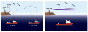
Traditional vessel navigation systems, which underpin most DP operations, heavily rely on satellite signals, sometimes as a single position source and sometimes as multiple sources, to meet class requirements.
But if your signals are blocked, jammed or spoofed, you have a problem, especially during critical operations near offshore platforms or while conducting precise seabed mapping.
Relying soley on satellites, with their common vulnerabilities, for your vessel’s position isn’t always enough. While deploying seafloor hardware is an option, it adds time and can limit your operational footprint. This is where SPRINT-Nav DP changes the game.
SPRINT-Nav DP – a leap forward in maritime navigation
Building on a decade of proven performance in our SPRINT-Nav family of underwater navigation sensors, SPRINT-Nav DP is designed to deliver continuous, accurate positioning information even when GPS signals are compromised.
It’s ideal for DP2 vessels working in shallow water and nearshore environments where GNSS signals are often blocked, distorted or unreliable.
Whether it’s wind farms, risers or coastal structures causing interference, SPRINT-Nav DP ensures you stay on position when it matters most.
With SPRINT-Nav DP continuosly running, you’ve also got that indepedent input, ensuring continuity of your position reference – disruption of which, if you’re suffering from outtages, can cause timing issues and even your AIS to drop out.