Sonardyne
Support Centre

Making critical connections: Powering ice‑seal science in Alaska

Studying life beneath shifting Arctic sea ice is notoriously difficult, yet the changes unfolding there affect ecosystems, coastal communities and future climate resilience. Learn how UNH scientists, using our RT 6 acoustic releases, are able to deploy and recover hydrophones safely under moving ice—making it possible to capture the long‑term data needed to understand Alaska’s changing marine life and the people who depend on it.

The challenge

Coastal Indigenous communities in parts of Alaska rely on bearded seals for food security, cultural continuity and generational knowledge transfer. Blut changing sea‑ice patterns are disrupting when and where these seals appear – or whether they appear at all.

This shift raised urgent concerns about whether the seals’ breeding behaviour or distribution was changing. It’s a shift that scientists at the University of New Hampshire (UNH) are researching in support of – and with support from – the Ice Seal Committee (ISC) and the North Slope Borough Dept. of Wildlife Management.

As part of their work, UNH researchers are investigating two Alaskan regions. In Utqiaġvik, where sea ice is still reliably present in spring, they are studying the timing of the bearded seals’ unique breeding chorus in relation to when the ice breakup happens.

In Bristol Bay, where spring ice has become inconsistent or absent, their focus is on whether bearded seals are still breeding at all, following community reports of declines in sightings.

This required hydrophones to remain underwater for months beneath moving ice. Because any surface float or marker would be destroyed or dragged away, the entire system had to be fully subsurface, making a reliable acoustic release essential for recovering the instruments.

The solution

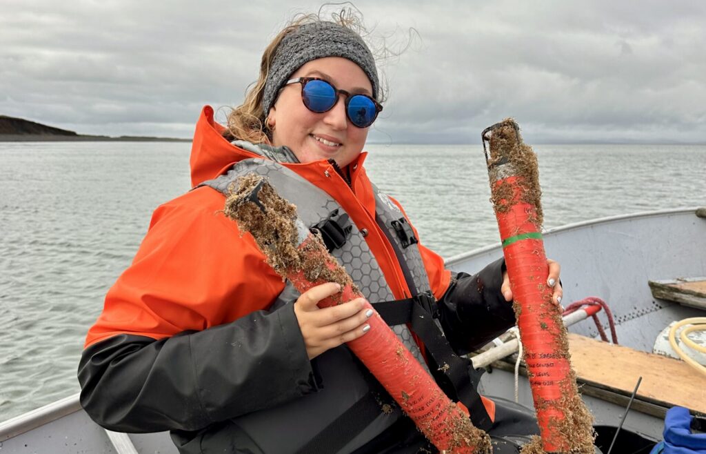
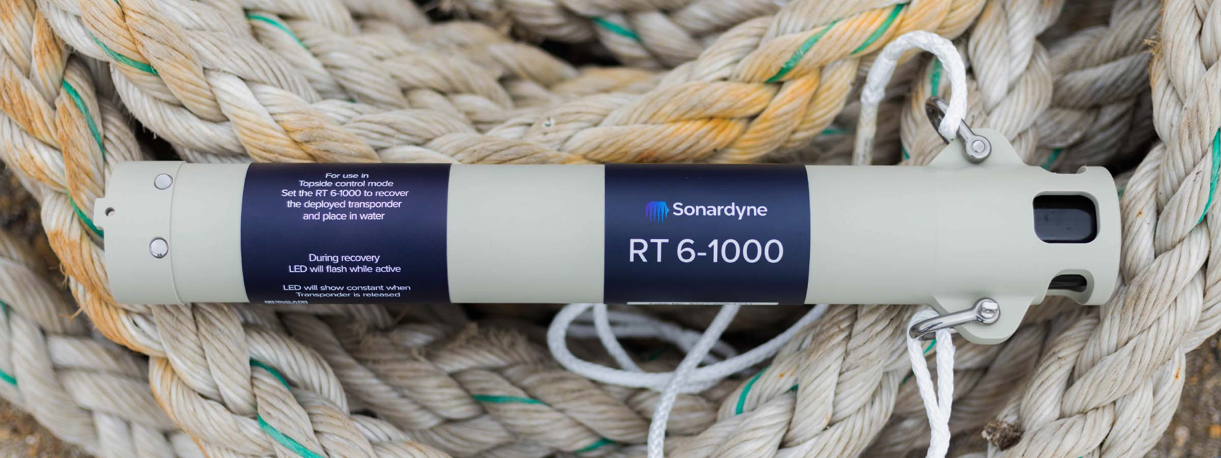
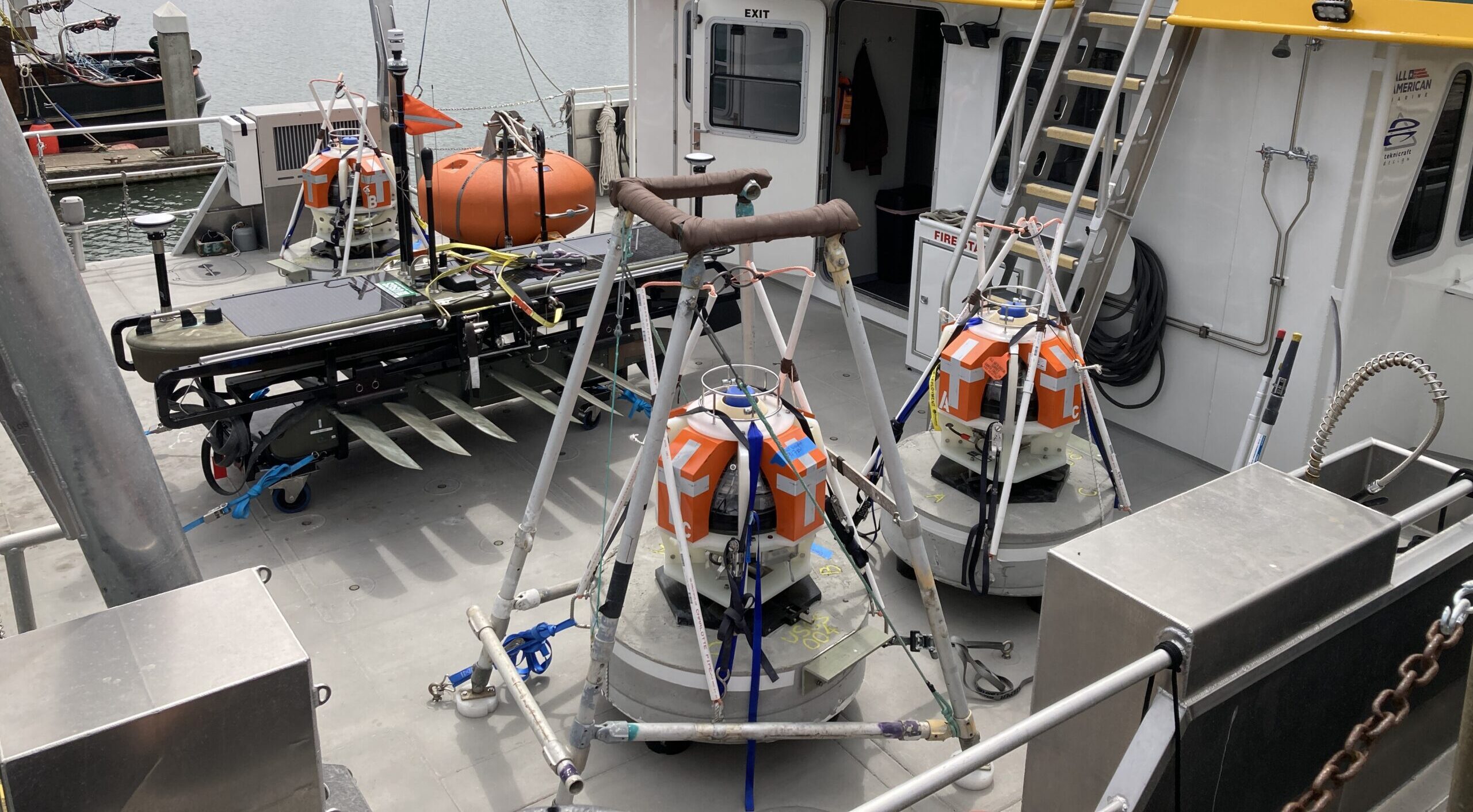
UNH selected Sonardyne RT 6‑1000 acoustic releases—the only way to safely moor long‑term acoustic instruments, without having any part of the system at the surface, in ice‑covered seas.

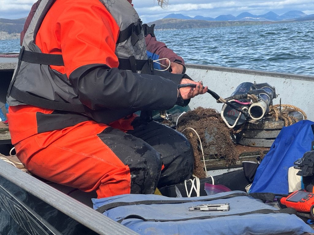
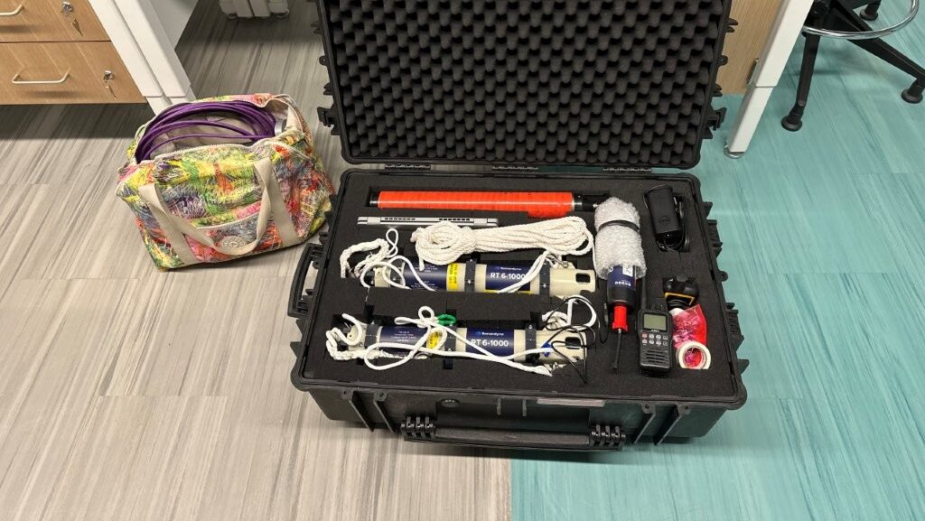
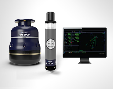
The RT 6‑1000 is our acoustic release transponder designed for seabed deployments, enabling users to deploy, track, locate and recover subsea equipment such as hydrophones, sensors and moorings.


  • It’s compact, but built for use in harsh environments. That includes being corrosion resistant and rated down to 1,000 m water depth.
  • It’s also able to support loads of up to 150 kg for periods of up to 13 months and, thanks to its inbuilt inclinometer, it’s easy to check loads have landed the right way up.
  • It’s also easy to use, either with a deck topside unit, NFC mobile phone app or any Sonardyne Ranger 2 USBL system, when you want full tracking and release control.
  • It can come with an optional rope canister, for raising tools, sensors or mooring lines as the device ascents, which can be useful in shallow or manual recovery environments.

The UNH set up

Rachel Lewis, a marine biology graduate student at UNH, has been working with our releases for this research. She works in UNH’s Marine Bioacoustics and Behavioral Ecology Lab—often called the “SeaBABEL” lab—led by Dr Michelle Fournet.

“UNH deploys a fully subsurface mooring system designed to withstand winter sea‑ice movement,” she explains. “Each mooring begins with a seabed anchor, topped with an RT 6‑1000 acoustic release, followed by a rope canister, the hydrophone, and a small subsurface float. The entire assembly is kept short—around 15–20 feet—to avoid interaction with drifting ice.”


  • In Utqiaġvik, the team uses arrays of five hydrophones to capture a wider soundscape.
  • In Bristol Bay, they deploy four hydrophones spaced well apart to detect any bearded‑seal calls across the coastal area. All systems are placed in autumn and record through the winter and the spring breeding season.

“Recovery is carried out in spring from small boats using a dunking transducer to command the RT 6 to release the anchor, allowing the float to bring the hydrophone line to the surface—even if ice has shifted the mooring,” explains Rachel.

One Bristol Bay unit was found around 2,000 m from where it was deployed but still responded to acoustic commands.

The results

Using the RT 6‑1000 acoustic releases allowed the UNH team to deploy and recover every hydrophone mooring, even in harsh under‑ice conditions where surface buoys are impossible.

“Without the RT 6‑1000 releases, the deployments wouldn’t happen because you can’t have a surface float in an area that gets sea ice,” says researcher Rachel Lewis. Across the project, the team completed 12 deployments and recovered all 12 instruments, which Lewis described as “kind of unheard of” in Arctic fieldwork.

The RT 6 also proved reliable even when equipment was moved significantly by ice. During one retrieval, a mooring had been dragged around 2,000 m, yet the release continued to respond, enabling the team to locate and recover it after several hours of searching. This performance gave the researchers confidence to run multi‑month, unattended winter deployments, knowing the systems would still be recoverable in spring.

Deployments

0

Recoveries

0

Success

0

%

What the data says

With full datasets from both Arctic and sub‑Arctic sites, the team have been able to document a consistent five‑day lag between sea‑ice breakup and the start of the bearded‑seal breeding chorus in Utqiaġvik. This indicates that the seals are following their preferred ice conditions northward as breakup occurs earlier each year.

In Bristol Bay, the same deployments confirmed no bearded‑seal breeding chorus during the 2025 season, suggesting a potential loss of breeding activity in this sub‑Arctic region, even though hunters still occasionally see seals locally.

“The ability to reliably deploy and retrieve these instruments means we can collect the continuous acoustic datasets needed to understand how bearded seals are responding to changing sea‑ice conditions in these regions,” says Rachel.

“This data is immediately useful to the people who live there: if breakup happens, we know seals start chorusing about five days later—which helps communities decide when to go out and look.

“Next, we’re taking these results back to the Ice Seal Committee, expanding our time series with historic and new recordings, and building an interactive site so hunters, students and managers can hear the chorus—or the lack of it—alongside the figures.”

Learn more:

Watch the podcast

Monitoring the restless earth for the next “big one”

When the 8.2 magnitude Chignik earthquake hit off the coast of Alaska in 2021, it was a big warning signal.

The largest earthquake in the US since 1965 and one of the largest globally in recent years; it was a reminder of the geohazards lurking, out of sight, off our coastlines.

Offshore events like these could trigger a tsunami, putting major coastal cities and regions at risk.

But, until recently, the geological activity that leads to an earthquake like Chignik was a significant blind spot to scientists, lying hidden and inaccessible beneath the waves.

Now, thanks to ongoing collaboration and development between underwater technology company Sonardyne, Scripps Institution of Oceanography and the U.S. Geological Survey (USGS), the ability to remotely monitor our restless earth is not just possible but also becoming standard practise.

Using a technique called GNSS-A, an increasing amount of coastline most vulnerable to earthquake and tsunami hazards, including the US Pacific Coast, is being monitored.

What is GNSS-A?

GNSS-A works by combining satellite positioning with underwater acoustics to track seafloor movement with centimetre-level accuracy. An uncrewed surface vessel (USV) with Sonardyne’s GNSS-A payload patrols above an array of Sonardyne Fetch transponders on the seabed.

Combining its known surface position with acoustic pulses down to each Fetch transponder allows it to calculate the precise position of each transponder – and therefore the position of the seabed it’s sitting on.

By repeating these measurements over time, scientists can track the movement of tectonic plates across faults to better understand and estimate earthquake and tsunami hazard.

One of the organisations using this technique to monitor subduction zones, where one plate is sliding under another, is the USGS.

They first started exploring its use in 2017, working in collaboration with the University of Hawaii and Scripps, and using a Wave Glider and seabed sensors, in order to measure how friction between two tectonic plates restricts sliding and causes a build-up of stress – essentially measuring “how stuck are the plates”.

Since then, they’ve continued to contribute to the development of GNSS-A using Sonardyne GNSS-A modules and Fetch transponders.

Expanding GNSS-A monitoring along the Cascadia Subduction Zone

A big focus for USGS is the Cascadia Subduction Zone, a 1,000 km long fault off the Pacific Northwest coast that runs from Vancouver Island in Canada to northern California.

Between 2021 and 2025, USGS has installed four monitoring sites on the seabed off the US Pacific coast at the southernmost extent of this zone.

They are part of a wider network along the Cascadia Subduction Zone where subduction involves three plates, the Explorer, Juan de Fuca and the Gorda, sliding beneath the North American Plate, creating the potential for magnitude 9+ earthquakes and large tsunamis.

The USGS GNSS-A sites, each with three Fetch transponders, are on the southernmost Gorda plate where the uncertainty of the Gorda plate motion relative to the North American plate motion has implications on the size and recurrence of earthquakes in the region.

“Before we had this capability, we were only able to use GPS networks on land to estimate, to a sub-millimetre level, the slow movements of the seafloor 50 plus miles offshore,” says Todd Ericksen, Geodetic Engineer at the USGS’ Earthquake Science Center in California.

“But the seafloor was a blind spot; a major missing piece of the global tectonic jigsaw puzzle which meant the true scale of the hazard beneath the ocean was largely unknown. Our instruments stopped at the shoreline.”

“For somewhere like the Cascadia subduction zone, where oceanic plates are being subducted beneath the North American plate, seafloor geodetic sites are filling a major gap, helping us to better understand earthquake and tsunami hazard. If plates ‘lock’ in this zone, building up stress, that whole coastline, and cities like Vancouver, Victoria and Seattle, face significant tsunami risk.”

Critical insights from the Aleutian subduction zone

One of the tectonic sources of large earthquakes that USGS has been monitoring is the Aleutian Subduction Zone. It was here that the Chignik earthquake struck – and USGS was ready for a post-earthquake response mission.

Just a couple of years before, three GNSS-A monitoring sites had been set up on the seafloor off Alaska, in the Aleutian subduction zone, by a team of scientists funded by US National Science Foundation (NSF).

Several Wave Glider surveys had been carried by the USGS and Scripps prior to the M8.2 Chignik earthquake, monitoring the position of the sites in about 1,200 m water depth.

Within weeks of the earthquake, USGS had their Wave Glider back out to measure what movement there had been during and shortly after the earthquake.

Despite challenging weather conditions, the mission collected high-fidelity GNSS and acoustic data with eye-opening results.

“The tsunami was modest, but the seismic event was the largest in the US for nearly six decades,” says Ericksen, “so we expected a large movement. But it was incredible to know exactly how much – and that was 1.4 m.” This was a critical insight into the co- and post-seismic movement, helping to understand subduction zone dynamics.”

The big question was, did the Chignik earthquake increase the state of stress and tsunami potential on the up-dip portion of the fault or not?

“The measurements showed that the fault moved 2 – 3 m horizontally in a shallow part of the fault, less than 20 km below the seabed, helping us to understand how stress builds up along the fault and is released in an earthquake,” he says

“These results suggested that the cumulative slip had relieved stress on the shallow portion of the fault and therefore, the Chignik earthquake likely did not increase tsunami potential of the shallow fault.

“It also showed the effectiveness of the GNSS-A technique and the utility of rapid response GNSS-A measurements to better assess tsunami and earthquake hazards in the region.”

Read more about the Chignik data here.

The origins of GNSS-A

The ability to measure the movement of plates on the seabed is not that new. It’s based on what was originally called the GNSS-A technique, first developed by Scripps, specifically David Chadwell and Fred Spiess.

“Combining GNSS positioning and acoustic measurements to track seabed movement was a clever idea – and it worked,” says Michelle Barnett, Ocean Science Business Development Manager, at Sonardyne.

“But the cost of using crewed ships to do the positioning made it cost prohibitive. It was also technically challenging.”

“So, working with Scripps, in the early 2010s, we developed a combination of our Fetch long-life sensors and an off-the-shelf GNSS-A payload for Wave Gliders that can go out and do the survey work at a much lower cost than using a crewed ship.”

Worth the wait, even when waiting on weather

The technique is not without its challenges, however. After gathering the positions of the Aleutian subduction zone transponders, Ericksen and his team were naturally keen to see the data.

Due to the significant amounts of data involved – we’re talking 25-30 GB per site (comprising three Fetch) – only sub-samples are sent back to shore from the USV, primarily for quality control.

So, they have to wait until the USV comes back – or is brought back – to shore. Low levels of daylight in the Alaskan winter (when the Chignik survey was carried out) meant limited power availability for the USV.

Combined with bad weather, coordinating its recovery proved challenging, resulting in it taking four-months to recover the Wave Glider and offload the data.

Still, the wait was worthwhile and the results are providing greater insights than we’ve ever had before.

Read more

Sonardyne technology chosen for new Canadian seabed observatory.

TL;DR:

Scientists can now monitor underwater earthquake zones using GNSS-A technology—combining satellite positioning with acoustic sensors on the seabed. This breakthrough, developed through collaboration between Sonardyne, Scripps Institution of Oceanography, and the USGS, allows them to track how tectonic plates move and where stress is building up, which was previously a “blind spot” beneath the ocean.

The technology: Sonardyne’s Fetch transponders sit on the seabed in arrays, while Wave Glider robots equipped with Sonardyne’s GNSS-A payload circle above them, using acoustic signals to precisely measure their positions over time. This makes continuous offshore monitoring both feasible and cost-effective for the first time.

Deep‑ocean accuracy for Germany’s research vessel fleet

Germany's blue-water research vessel fleet ranks among the world's most advanced and capable when it comes to ocean-going science.

This reputation and capability will deepen further this year, when the new, 125 m-long Meteor IV research vessel is delivered – ready for scientific missions around the world, across Atlantic, Pacific and Indian Oceans, as well as the Mediterranean.

Operated by GEOMAR Helmholtz Centre for Ocean Research Kiel, Meteor IV will bring a larger, globally capable, climate‑focused flagship with significant laboratory and deck capacity into Germany’s fleet.

It’s capable of covering 5,000 nautical miles, spending 52 days at sea, with 36 crew and 35 scientists able to work in 17 specialised laboratories over 585 sq m.

Science with precision

Underpinning its impressive scientific capability is the precision with which it can pinpoint, track and communicate with underwater equipment—enabling scientists to map, survey, sample and monitor the deep ocean.

This is why Meteor IV, like its sister ships the RV Sonne and RV Maria S. Merian, will come fitted with our Ranger 2 Ultra-Short BaseLine (USBL) positioning system.

Ranger 2 USBL enables precise real-time tracking of remotely operated vehicles (ROVs), autonomous underwater vehicles (AUVs), towed platforms and sensors and other deployed instruments to ranges of beyond 7,000 m.


Join the expedition

Ahead of the Meteor IV entering the fleet, here’s a look at some of the work its sister ships have been doing, with the support of Ranger 2 USBL.

RV SONNE in the Indian Ocean. University of Hamburg / LDF / Photo by Tim Kalvelage.

RV Sonne

RV Sonne is a deep‑sea research vessel, about 116 m long and built in 2014 for multidisciplinary work mainly in the Pacific and Indian Oceans.

Clarion Clipperton Zone, Pacific Ocean – Biogeochemical and biological assessment of deep-sea mining crater

Earlier this year, the RV Sonne recently completed an expedition to the Clarion‑Clipperton Zone in the Pacific Ocean to assess the impacts of deep sea mining trials on the seafloor from 2021. Ranger 2 USBL was used to track equipment, including the ROV Odysseus (on dives lasting up to 56 hours!), benthic chambers and sampling platforms, down to the seafloor in about 4,000 m water depth.

Although the scientists were able to use a visually-guided multi-corer, they had to rely on the USBL system alone to accurately position the box-corer onto caterpillar tracks left in 2021. This was particularly necessary to gain larger volumes of sediment required to reach macrofaunal abundances that are statistically significant. Learn more

Southwestern Pacific Ocean – Hydrothermal vent system research

Ranger 2 was used to position the ROV Kiel  6000 during deep‑sea dives, allowing it to navigate accurately enough to reveal a previously unknown hydrothermal vent system, at around 1,300 m water depth, in the Tabar–Lihir–Tanga–Feni island chain of Papua New Guinea. During the expedition (SO299), this precise positioning helped researchers discover the unusual “Karambusel” field, where hot mineral‑rich fluids and methane‑rich gases rise side‑by‑side—an environment not seen anywhere else in the world. Learn more

Eastern Pacific Ocean – Tracking tectonic strain

GEOMAR’s work from the RV Sonne has involved deploying our long‑endurance AMT seabed arrays to monitor tectonic strain along the Nazca–South American plate boundary. These instruments, precisely positioned by Ranger 2 USBL across complex seafloor terrain, capture precise geodetic data from depths of 2,800 m to over 5,000 m. Ranger also reliably tracked and communicate with the instruments during subsequent survey and data‑recovery missions. Learn more

MERIAN in the Irminger Sea. Pictures from University of Hamburg / LDF / UHHN, by Verch.

RV Maria S. Merian

The RV Maria S. Merian is an ice‑strengthened research vessel, at 94.8 m long, and in service since 2006.

Atlantic Ocean, off Newfoundland – Collaboration with SAMS for Fetch AZA data retrieval (pre-existing other articles)

Ranger 2 was used to accurately locate and communicate with a Fetch AZA deployed on the seabed by the Scottish Association of Marine Science (SAMS). This enabled the crew to command and retrieve its long‑term oceanographic dataset during a 2024 transit in the North Atlantic, while it happened to be passing through the area. Ranger 2 allowed the crew to establish a reliable communications link with the Fetch AZA instrument, upload its stored measurements and confirm its status on the seafloor with shore-based colleagues, supporting ongoing monitoring efforts in the region.

Data from these sensors is discussed in a recent Geophysical Research Letters paper looking at the use of AZAs in physical oceanography. Learn more

Watch how SAMS is using Fetch

Norwegian-Greenland Sea – Hydrothermal vent research

Using the MARUM‑QUEST 4000 ROV, positioned using Ranger 2 USBL, scientists were able to pinpoint and explore a hidden hydrothermal vent system more than 3,000 m deep off Svalbard—an area where no such activity had ever been confirmed before. During expedition MSM109, this precise seafloor exploration revealed the newly named “Jøtul” field, a rare Arctic vent system emitting super‑heated, mineral‑rich fluids and unusually high methane levels—marking the first hydrothermal discovery along the 500‑km Knipovich Ridge. Learn more

Ionian Sea – Mount Etna Flank Movement

Ranger 2 was used to guide the search for five Sonardyne AMT geodesy stations deployed on the flanks of Mount Etna. This enabled the crew to accurately navigate to their positions at around 1,038 m water depth during the 2024 MSM132 expedition. Although the recovery ultimately failed due to issues with third‑party equipment, the precise acoustic positioning brought the team to within a metre of the first AMT station, demonstrating the reliability of the underwater tracking even under challenging conditions. Learn more

Ranger 2 Gyro USBL gives you a reliable, all‑in‑one way to track and communicate with your underwater equipment, whether that’s an ROV, AUV or seabed instruments spread across a study site.

Ranger 2 for ocean research

Its integrated design keeps positioning accurate and steady, even when the ship is moving, helping teams work efficiently in real‑world sea conditions.

Because it delivers dependable subsea tracking and two‑way data links, you can recover information, update instrument settings or navigate complex dives confidently—reducing vessel time and simplifying operations.

Focus on discovery, not on the tools needed to make it happen.

The METEOR IV. Photo from University of Hamburg / LDF / by Marc Petrikowski.

Meteor IV fact file   

Meteor IV is being built by the Meyer-Fassmer Spezialschiffbau consortium on behalf of Germany’s Federal Ministry of Research, Technology and Space (BMFTR)

The ship will replace the previous Meteor and the research vessel Poseidon.

GEOMAR will operate the ship, with its scientific missions planned by the German Research Fleet Coordination Centre (Leitstelle Deutsche Forschungsschiffe) at the University of Hamburg.

One of its first major scientific missions will be the one-year FUTURO research campaign off the west coast of Africa, investigating how climate change and human pressures are altering West Africa’s upwelling system and marine ecosystems.

Key numbers

Dimensions: Length: 125 m, width: 21 m
Maximum speed: 12 knots
Range: 15,000 nautical miles
Duration at sea: 52 days
Crew: 36 persons | Scientists: 35 persons

Total workspace

730 sq m dedicated to scientific purposes
including 585 sq m of laboratory space.
17 specialized labs, featuring climate chambers and atmospheric chemistry facilities for in-depth ocean-atmosphere interaction studies.

Key equipment

High-precision echo sounders
Research winches for depths up to 12,000 m with real-time fiber-optic video transmission
Five powerful cranes
Sonardyne Ranger 2 Gyro USBL

Payload capacity

Ample deck and container space for large gear like ROVs, AUVs, anchors and related equipment.