Blog written by: Ioseba Tena, Global Business Manager – Marine Robotic Systems, Sonardyne International Ltd.
The performance of marine robotic systems is directly linked to how well they are able to sense their environment and process the sensed data. Can they find their way? Can they make sense of their surrounding? It’s all down to the payload instruments. Our integrated, highly accurate instruments add both value and capability, and in this blog I will explain how.
Navigation instruments
 Subsea inertial navigation instruments and capability have evolved a lot over the last two decades. Once typically the reserve of high-end government contracts, the technology has become more readily available and has resulted in the production of a new generation of cost-effective instruments that are transforming the way in which marine robots interface with the subsea environment.
It has been far from easy. The building blocks required to achieve the accuracy needed to satisfy survey-grade operations has taken us a decade to realise.
One of our major navigation building blocks is a Honeywell Ring Laser Gyro (RLG). This instrument is capable of measuring changes in rotation along its axis with incredible accuracy. It has become the standard navigation gyroscope in almost all commercial aircraft and a wide range of land, air and sea applications. It’s reliable also – demonstrating Mean Times Between Failures (MTBF) in excess of 400,000 hours. With over 100,000 gyros in circulation, it is the world’s leading go-to technology.
An RLG by itself is great, but not sufficient to navigate by. We need to be able to estimate our position and heading and there’s three distinct steps to this. Step one – develop an Inertial Motion Unit (IMU) capable of providing true North heading measurements. In other words an Attitude Heading Reference System. Step two – develop onboard processing which turns raw IMU data into an Inertial Navigation System (INS) capable of generating position and heading estimates. Finally step 3 – aid the INS with complimentary instruments such as a Doppler Velocity Log (DVL). The result of these steps? Lodestar, SPRINT and Syrinx.
Lodestar – Attitude Heading Reference System
By mounting three gyros orthogonally together with three accelerometers, in a strap-down gyro configuration, our Lodestar is able to find true North. The maths is simple to understand; input the Latitude from a GPS signal and we know what the rotation of the Earth is at any one point in the globe. The strap-down gyro measures gravity. The rotation of the Earth is perpendicular to that. North in turn is also perpendicular to that rotation. The beauty of an RLG is that it is accurate enough to measure the Earth’s rotation, the vital ingredient to solve the equation.
However, alignment of the AHRS is a difficult challenge requiring generous amounts of number crunching. Lodestar does that number crunching in the background when the system is started and finds North in under 10 minutes once the system is configured. It won’t lose North either as long as it is switched on.
SPRINT – Inertial Navigation System
The algorithms for INS are capable of taking the outputs from the IMU and estimating a position and heading. This is done by keeping accurate estimates of the errors inherent on the sensors and using these error calculations to correct the position and heading estimate calculated by integrating the accelerometer and gyro measurements. Every Lodestar can be turned into a SPRINT with a simple firmware update – the hardware is common to both platforms. The trick with INS is to use aiding sensors to accurately estimate the errors in the instruments. This is a very complex challenge and one that we have focussed heavily on solving. In 2015, we introduced our Syrinx DVL and it changed the game.
Syrinx – Doppler Velocity Log
Syrinx calculates the Doppler shift generated by four beams of sound as they reflect from the seafloor to calculate the robot’s velocity relative to it. This velocity estimate can be integrated over time to generate an estimate of the robot’s position. Syrinx by itself can be used as an input to a control system enabling automatic station keeping, but as an aiding sensor to SPRINT, it is used to generate accurate error estimates for the instruments used to compute the navigation solution. SPRINT actually uses each of the DVL beams as individual aiding sources which helps improve the overall accuracy and integrity of the system and improves results in challenging seafloor environments.
SPRINT-Nav – Combined INS and DVL
SPRINT-Nav is a single instrument, housing an IMU, an AHRS computer, an INS navigation computer, a DVL and a high-accuracy pressure sensor. It’s the easiest way to integrate survey ready navigation into your robotic platform. Multiple connectors enable multiple outputs. This means your robot can feed inputs directly to its control system and your payload can also be served through a different output. It is also capable of receiving aiding from other sensors.
A combined instrument reduces your power requirements, simplifies integration and provides class-leading performance as good as a fraction of a metre over many kilometres travelled. As the SPRINT and Syrinx are permanently aligned, there’s no need to constantly align the DVL. Operating SPRINT-Nav is simple. Switch the unit on, wait 10 minutes to find North and that’s it. The INS navigation computer is initialised with the AHRS estimates automatically.
SPRINT-Nav, aided with updates from Ultra-Short BaseLine (USBL) instruments, can be used to map the seabed to a level of accuracy suitable for most survey jobs. In combination with our AvTrak 6 family (see next page), your AUVs can navigate and communicate with the mothership regularly and reliably.
Payload Instruments
 Once you know where your robot is, the next challenge is to understand its environment. We offer two ways to help; sonar imaging to let your vehicle see what’s around it and wireless modems to let it communicate.
Solstice – High resolution sonar
Solstice is a Multi Aperture Sonar (MAS) where the multi-beam input from 32 elements is dynamically focussed to ensure pixel perfect imaging across the 200 metre swath. Its compact design is suitable for low logistic platforms. By using multiple apertures, the data is massively enhanced and the Signal-to-Noise Ratio (SNR) is improved. The process generates narrow along-track beams and at 18 watts, it places very little drain on your power budget. This means that Solstice users can generate ultra-high resolution pictures of the environment suitable for Hydrography and Mine Counter-Measures (MCM) persistently.
BlueComm – Optical modem
 Robust, low bandwidth communications over long distances using acoustics is available through our 6G family of products. But what happens when you need to share large volumes of data?
Historically, you’ve extracted on the surface and sent it back to base to analyse, but BlueComm changes all that. Using the power of the EM spectrum, BlueComm modems can pass incredible volumes of data over hundreds of metres to one another. This means that an AUV or an ROV flies through a field full of data logging instruments and harvests their data quickly and efficiently. BlueComm is now being used by AUV manufacturers to mount onto docking stations. It is also being used to enable communications with sensors permanently deployed on subsea fields. It’s transforming the way we think about the subsea environment. Now every subsea asset can be made a ‘connected’ subsea asset all the way back to your office.
Under pressure and out of sight
If you’re in the marine robotics domain then you already know how challenging the subsea environment is. Your robots face a constant onslaught from waves and currents. Marine growth can accumulate on actuators and sensors. Tremendous pressure with depth of water requires robust housings and water-tight seals. Simple tasks that we carry out on land when carried out subsea become true engineering feats.
We have engineered solutions to meet your every need. 45 years of experience has taught us which materials to use, how to house the sensors and actuators and how to use the environment to our advantage. Our integrated instruments reduce your risk, save you time and let you get on with the job in hand.
One size doesn’t fit all
Marine robotic systems have evolved to meet the challenging ocean conditions and this has resulted in the development of systems that range from the small one-man portable vehicles to the very large platforms intended to replace ships. By engaging with leading manufacturers, we’ve now developed a range of Original Equipment Manufacturer (OEM) solutions that can be easily integrated to your robot’s own pressure housing. The OEM range enables manufacturers the flexibility to integrate our class-leading solutions and make the most effective use of the space. And our engineering services, testing, trialling and training services are here to assist you every step of the way.
Blog written by: Ioseba Tena, Global Business Manager – Marine Robotic Systems, Sonardyne International Ltd.
 Walking around Ocean Business 2017 in Southampton a couple of weeks ago was fun. All the usual Autonomous Underwater Vehicle (AUVs) providers were in attendance boasting, rightfully, about the growth in the sector. I was also glad to see, alongside the established companies, new players emerging. The shapes, sizes, applications and concepts for operating the systems on offer are mind-blowing. I enjoyed the discussions too. One moment I was having a conversation about a life resident AUVs stationed offshore at thousands of metres depth servicing an offshore field, the next I was talking about swarms of small AUVs collaborating to carry out detailed oceanographic surveys.
Just where are my AUVs?
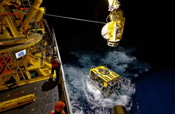
Each and every time the subject came back to one recurring theme; “Just where are my AUVs?” AUVs spend all their working hours out of sight, silently ‘mowing the lawn’ and working hard to gather your ocean data. But whatever role you assign them, from monitoring a pipeline, searching for debris or looking for mines, one thing’s in common – you always want to know where your very expensive assets are.
![]() All surveys starts with very careful planning. While the AUVs sit on the deck, the operator plans the mission in meticulous detail; checking each and every waypoint to make sure that the AUVs will be successful, and in particular, will not collide with obstacles along their route. When the mission is ready, it is uploaded into the AUVs’ control systems and then… it’s leap of faith time. The AUVs are released into the sea. They submerge and that’s it. They are gone for hours. Managing one AUV is hard enough, but judging from my conversations at Ocean Business emerging concepts of operations require that we track and monitor multiple systems.
All surveys starts with very careful planning. While the AUVs sit on the deck, the operator plans the mission in meticulous detail; checking each and every waypoint to make sure that the AUVs will be successful, and in particular, will not collide with obstacles along their route. When the mission is ready, it is uploaded into the AUVs’ control systems and then… it’s leap of faith time. The AUVs are released into the sea. They submerge and that’s it. They are gone for hours. Managing one AUV is hard enough, but judging from my conversations at Ocean Business emerging concepts of operations require that we track and monitor multiple systems.
This is where our AvTrak instrument comes in. I’ve only been with Sonardyne a few months but I’ve quickly come to appreciate that it’s one of the most versatile of instrument platforms you could fit to your AUV. Inertial aiding, long-range tracking, communicating and mission planning – you got it. And with the introduction of the Nano OEM version which is about the size of your business card, no matter how small your vehicle is – you can get in on-board.
All models of AvTrak are 6G compatible so not only can they measure ranges to reference transponders with great precision, they can also exchange data within each range update cycle. Through the use of simple open interfaces and protocols, using Wideband 2 ranging and data exchange capabilities, AvTrak can act as beacon for a surface USBL. It can also communicate with surface vessels, transponders on the seabed and other AUVs. Share health status updates, alter mission plans, share goals, harvest data … The possibilities are endless.
Tom Bennetts Projects Manager at Sonardyne demonstrated AvTrak functionality during Ocean Business, “Customers were impressed by the ability to tag along data with every ranging cycle, and how the system could automatically adapt the pings to fit more data if required. We are talking about a system built using a technology platform proven world-wide from thousands of deployments.”
One size doesn’t fit all
I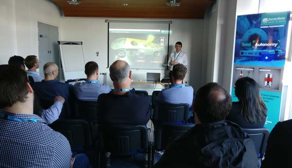 personally think that the beauty of our AvTrak 6 family of instruments lies in the flexibility it affords the AUV manufacturers and their users. Yes… we can track tens of AUVs. We work out their position. We can communicate it back to them using advanced, acoustic bi-directional communications. The truth is we could do that since the introduction of Wideband!
We’ve worked hard to make the instruments compatible with every AUV platform and judging from the technology displayed at Ocean Business, I’m glad we did this. Today our 7,000 metre depth rated AvTrak 6 is capable of meeting the most strict accuracy requirements at extreme ranges. It offers an emergency battery lasting 30 days, control of releases, burn-wire and a drop weight function. In contrast our AvTrak 6 Nano OEM measuring just 88 mm x 56 mm offers the same tracking and data exchange and still boasts 10 days of emergency relocation battery life – just in case the worst happens! It has already been integrated to micro-AUVs making them compatible with a world-wide network of survey vessels equipped with our 6G USBL systems.
Remember whether you are running four or twenty four hour missions, all missions cost; mobilisation, crew, support vessel, ancillary equipment, time and demobilisation. Tracking the AUV can help mitigate for errors in the planning and in the execution. You can check as the mission evolves that your AUV is where you need it to be. Your AUV can save you money by not getting lost and it can make you money by going where it needs to go!
So next time you are wondering where your AUVs are, get in touch with us. We will help you find them.
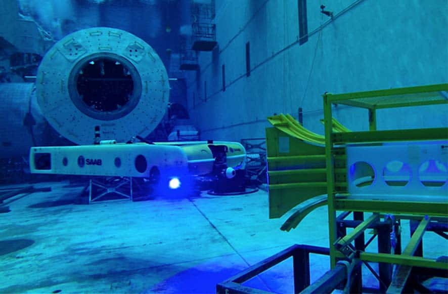
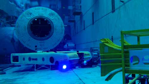
Subsea technology company, Sonardyne International Ltd, has delivered its latest consignment of AvTrak 6 acoustic communications and navigation hardware to defence and security company Saab’s subsidiary Saab Seaeye.
Offered as an optional-fit sensor on the Sabertooth hybrid AUV/ROV, AvTrak 6 forms part of the vehicle’s integrated navigation and communications system. It allows mission updates, status checking and navigation aiding to be wirelessly sent to and from the vehicle, eliminating the need for the vehicle to re-surface or dock with an underwater garage.
The unique design of Saab’s Sabertooth vehicle allows it to be configured as a conventional tethered ROV or free-flying AUV depending on the operational requirements of the user. It is depth rated to 3,000 metres, has a long excursion range and is equipped with a control system that affords it six degrees of freedom. This level of manoeuvrability makes the vehicle suitable for a wide range of subsea tasks including light intervention and inspection duties within the offshore oil and gas sector.
AvTrak 6 adds to the versatility of the Saberbooth vehicle by combining the functions of an acoustic tracking transponder, transceiver and wireless modem link in a package that consumes only a small amount of payload space and power. It is available in a variety of configurations including depth ratings to 7,000 metres, electronics-only (OEM) for customer integration and a customisable command language that offers features such as mission abort and ballast jettison.
During missions, Sabertooth pilots use AvTrak 6 for AUV-to-Vessel and AUV-to-AUV communications. This enables mission and status updates on operational vehicle parameters to be sent and received. Often when navigating across the seabed, AvTrak 6 is used to update the vehicle’s inertial navigation system with precise range data gathered from nearby transponders deployed on the seabed in support of oilfield survey and construction activities.
AUVs are generally operated from survey vessels equipped with Ultra-Short BaseLine (USBL) tracking technology. These systems allow the position of the vehicle relative to the vessel to be precisely tracked via a transponder attached to the vehicle. AvTrak 6’s USBL mode replaces the need for a separate transponder saving valuable space and is compatible with both Sonardyne and third-party systems including Kongsberg’s HiPAP®. An internal battery provides power and supports an emergency transponder mode for vehicle relocation.
Speaking about Saab’s decision to supply Sabertooth vehicles equipped with AvTrak 6s straight out of the factory, Alan MacDonald, Sales Manager for Sonardyne in Aberdeen said the announcement was,
[blockquote author=” Alan MacDonald, Sales Manager for Sonardyne”]”Recognition of the versatility and unrivalled performance this multi-functional acoustic technology provides”. He added, “We are delighted to report this latest order and look forward to supporting Saab and their clients during vehicle delivery and operational commissioning”[/blockquote]
For more information on AvTrak 6, click here.
Blog written by: Ioseba Tena, Global Business Manager – Marine Robotic Systems, Sonardyne International Ltd.
Google cars, Amazon drones, Uber self-driving taxis, pilot-less trains. Proof, if needed, that the age of the robot is finally upon us. They may not look human; they may not be sitting next to us, but given the staggering advancements being made on almost a daily basis, it will be a case of when, not if.
 For those of us working in technical industries, it is no surprise that robots are becoming common tools accessible to all. In the marine industry, Remotely Operated Vehicles (ROVs) have been used for decades. ROVs changed the game, making it possible to reach untapped oil reservoirs in thousands of metres of water, work around the clock and remove the risk of sending divers to work. More recently, Autonomous Underwater Vehicles (AUVs) have also established themselves. World navies use them, for example, to help with the difficult and dangerous task of finding and disposing of underwater mines. All the signs indicate that these systems are becoming more widely accepted and with mission endurances increasing all the time, their use is expected grow.
However, unlike consumer operated drones, these marine platforms require a team of highly trained specialists to operate them and operations must be run from vessels that have been specially adapted to look after them. And that means only one thing – $$$$$. But high running costs are a problem that many developers are starting to tackle. They are working to make the platforms more accessible, to simplify the work of the operator, to build systems capable of taking care of themselves.
Just as the consumer world is coming to terms with sharing the roads with driverless cars and packages that deliver themselves, wider acceptance of marine robotic systems comes down to trust. Can we trust that the robots that we produce will do what we want them to do?
Trust has to be earned
I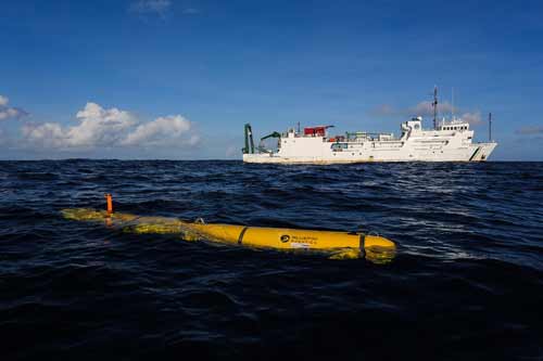 n the maritime domain, just as in life in general, trust is hard earned. Often, robots are working in inhospitable and remote environments. You need, and want, to trust that your robot is doing the right thing, but you are not there with it, guiding each of its decisions and actions. In the case of a ROV, your robotic platform may be operating at thousands of metres of depth controlled via a tether and a human pilot in the chair. In the case of a tether-less AUV, it will be working through an acoustic link and may not even be able to take simple, direct instructions. Unmanned Surface Vehicles (USVs) often operate ‘over the horizon’ or thousands of nautical miles from your office controlled by satellite communications. Regardless of which platform you use, and your concept of operations, the bottom line is that you need to trust it by building a track record of success.
How do you do this when taking your first steps with a new robot? We take baby steps. We monitor it, we communicate with it and we take control. Soon we will become more aware of how the robot behaves and we will settle into a pattern of operations which are predictable and which we can trust.
Shell Ocean Discovery XPRIZE sets the bar
It’s important that we make this work happen. As of today, only 5% of our planet has been explored yet it provides 50% of our oxygen. In fact, we know more about the surface of Mars than we know about the Earth’s ocean bottom. Initiatives like the Shell Ocean Discovery XPRIZE recognises that more needs to be done and it has set out a challenge to develop robotic systems that will launch from the shore or the air and will be able to carry out very accurate surveys and inspections of the seafloor.
How do we interact with these robots? Helping to monitor, communicate and control our robots requires a lot of effort. To do so we must solve challenges thrown at us by the environment. Underwater, everything is complicated by the fact that electromagnetic waves dissipate quickly meaning we can’t make use of the GPS technology that’s in every smart phone to localise our submerged robots. Video monitoring is also limited to tens of metres in exceptional circumstances when the water is clear. Where is my robot? What’s around it? What will it need to do next? These simple questions can’t be answered by using tools developed for autonomous cars or drones. Instead we have to use sound to communicate and explore over long distances.
Depth in sound
This is where we come in. We are industry leading when it comes to providing tools to help ROVs and their operators find their way. We are helping AUVs too – both to find their way and communicate large volumes of data over significant distances without a physical link. And we can even help your USV track and command an AUV – effectively a robot controlling a robot!
During 2017 and beyond, I hope to shine the spotlight on some of these tools. How and where they are built. I also want to get behind the mind of the developers. What were they thinking when they designed them? What challenges did they face?
And of course, I plan to explore how they are being used. Follow my blog as we take a journey to help us understand the technology. Get in touch any time
Innova AS, a specialist subsea engineering and technology company based in Norway, has selected acoustic and inertial navigation technology from Sonardyne International Ltd., for two new in-field resident ROVs (Remotely Operated Vehicles) being built in the country.
Each ROV will be installed with a co-housed Sonardyne SPRINT Inertial Navigation System (INS) and Syrinx Doppler Velocity Log (DVLs) to provide tightly coupled navigation data that will support a wide variety of survey and inspection missions in water depths up to 4,000 metres.
The contract was announced on the opening day of the Seabed Mapping and Inspection conference which is taking place this week in Geilo, Norway (8th-10th February). The two ROVs are being built by IKM Technology, this time for delivery to IKM Subsea, who has contracted Innova to supply various on-board sensors, including the navigation system, as part of the vehicle’s development programme.
The all-in-one design of SPRINT-Nav makes installation on AUVs and ROVs straightforward, saves payload space and importantly, improves subsea navigation integrity. The design also features a high accuracy pressure sensor which can be removed in the field for re-calibration and still allow the SPRINT-Nav unit to be deployed.
Introduced onto the market over 10 years ago, Sonardyne’s SPRINT makes optimal use of acoustic aiding from data sources including USBL, LBL and DVL and pressure sensors to improve the accuracy, precision and reliability of subsea vehicle positioning. Innova’s client will be among the first to benefit from Sonardyne’s third generation SPRINT which is smaller than previous models and features dual data outputs to support Survey and ROV teams working concurrently. Syrinx DVL provides tight beam-level aiding to SPRINT, allowing for unprecedented positioning performance, even if one or two DVL beams are unavailable. It differs from other 600 kHz DVLs on the market in that it offers a high altitude (up to 175 metres) navigation capability normally only available from a 300 kHz DVL with the high precision and accuracy of a 1200 kHz DVL- all whilst navigating over undulating and challenging terrain of any type.
[blockquote author=” Sven Eivind Torkildsen Sales Manager for Innova AS “]”Throughout this project, flexibility, cost-effectiveness and performance have been key factors in selecting the technology for our client’s new ROVs. SPRINT-Nav meets all these requirements – and many more besides – so we had no hesitation in specifying it”[/blockquote]
Alan MacDonald, Sales Manager with Sonardyne in Aberdeen said that the company was, “very much looking forward to supporting Innova during the vehicle integration and sea acceptance testing phases of the project.”
Sonardyne Inc., Houston, today announced it has supplied acoustically-aided inertial navigation technology to offshore engineering, procurement, construction and installation company, McDermott International, Inc., for its Lay Vessel 108 (LV 108).
The Ranger 2 Pro DP-INS system, the highest specification available from Sonardyne, is being used to support touchdown monitoring surveys of submarine cables, umbilicals and pipelines and as an independent position reference for the LV 108’s Kongsberg dynamic positioning (DP) system. McDermott’s LV 108 entered service in 2015 and is currently on contract in the Ichthys field, Western Australia.
Designed as a fast-transit, dynamically positioned (DP 2) vessel for subsea constructions support across a wide variety of water depths, the LV 108 has 21,528 sq ft of deck space and can accommodate a crew of 129. Dynamically positioned construction and installation vessels such as the LV 108, conventionally rely on Ultra-Short BaseLine (USBL) acoustics and the Global Navigation Satellite System (GNSS) as their primary sources of position reference data. However, a vessel’s station-keeping capability can be compromised in the event the USBL is affected by thruster aeration and noise and the GNSS signal is simultaneously interrupted. The latter is particularly common around equatorial regions and during periods of high solar radiation.
Sonardyne’s Ranger 2 Pro DP-INS system addresses this operational vulnerability. It aids vessel positioning by exploiting the long-term accuracy of Sonardyne’s Wideband 2 acoustic signal technology with high-integrity, high-update rate inertial measurements. The resulting navigation output has the ability to ride-through short-term acoustic disruptions and is completely independent from GNSS. In addition to the system’s deep water positioning performance and safety benefits, DP-INS has been proven to deliver valuable time and cost savings for vessel owners. It does not need a full seabed array of transponders to be installed and calibrated before subsea operations can commence. For most subsea tasks, positioning specifications can be met with only one or two transponders deployed on the seabed. Additionally, as the system needs only occasional aiding from the acoustics, transponder battery life is substantially increased and the need to task an ROV to deploy and recover transponders for servicing is reduced.
The equipment supplied to McDermott for the LV 108 included Sonardyne’s INS sensor co-located with the company’s sixth generation (6G) HPT acoustic transceiver. This hardware was installed on one of the vessel’s two Kongsberg through-hull deployment machines and interfaced directly with the vessel’s DP system, also supplied by Kongsberg.
[blockquote author=” Jason Peters, Global Survey Manager at McDermott “]”The decision to equip the LV 108 with Sonardyne’s DP-INS reflects our approach to fleet expansion and renewal. This strategy focuses on ensuring our vessels and acquisitions keep abreast of the industry’s growing demand for safe, efficient, cost-effective installation solutions for field developments across all water depths.”[/blockquote]
[blockquote author=” Ralph Gall, Technical Sales Manager at Sonardyne in Houston”]”DP-INS is a mature, field proven technology that addresses industry’s need for a third, independent DP reference. The LV 108 joins a significant fleet of vessels that now depend upon our acoustic inertial technology for safer and more efficient dynamic positioning operations.”[/blockquote]
For more information on Ranger 2 Pro DP-INS please click here.